Surin Islands
The Surin Islands (Thai: หมู่เกาะสุริน, romanized: muu gaw soo rin, Thai pronunciation: [mùː kɔ̀ʔ sùrin]) is a continental archipelago of five islands in the Andaman Sea, 55 kilometres (34 mi) from the Thai mainland.[3] Administratively, the islands are part of Tambon Ko Phra Thong, Khura Buri district, in Phang Nga province, Thailand.[1]
Native name: หมู่เกาะสุรินทร์ | ||||||||||||||||||||||||
|---|---|---|---|---|---|---|---|---|---|---|---|---|---|---|---|---|---|---|---|---|---|---|---|---|
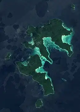
Satellite Photo in 2017 | ||||||||||||||||||||||||
 Surin Islands | ||||||||||||||||||||||||
| Geography | ||||||||||||||||||||||||
| Location | Andaman Sea | |||||||||||||||||||||||
| Coordinates | 9°25′N 97°52′E | |||||||||||||||||||||||
| Total islands | 5 | |||||||||||||||||||||||
| Major islands | Ko Surin Nuea, Ko Surin Tai | |||||||||||||||||||||||
| Area | 33 km2 (13 sq mi) | |||||||||||||||||||||||
| Length | 12.6 km (7.83 mi) | |||||||||||||||||||||||
| Width | 8.3 km (5.16 mi) | |||||||||||||||||||||||
| Highest elevation | 255 m (837 ft) | |||||||||||||||||||||||
| Administration | ||||||||||||||||||||||||
Thailand | ||||||||||||||||||||||||
| Region | Southern Thailand | |||||||||||||||||||||||
| Regional unit | Phang Nga | |||||||||||||||||||||||
| District | Khura Buri | |||||||||||||||||||||||
| Demographics | ||||||||||||||||||||||||
| Population | 150–330 [1][2] | |||||||||||||||||||||||
| Ethnic groups | Moken, Thai | |||||||||||||||||||||||
| Additional information | ||||||||||||||||||||||||
| Time zone |
| |||||||||||||||||||||||
| National park | ||||||||||||||||||||||||
Geography
Location
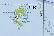
The two major islands are Ko Surin Nuea and Ko Surin Tai, separated by a 200 m (660 ft) channel that falls dry at low tide. Three substantially smaller ones are Ko Khai (or Ko Torinla), Ko Glang (or Ko Pachumba), and Ko Chi (or Ko Satok). Hin Kong and Hin Rap are small rocky islets. The limestone pinnacle Richelieu Rock (Hin Plo Naam), about 18 km (11 mi) east of Ko Khai and 45 kilometres (28 mi) from the mainland,[1][2] is named after admiral Andreas Richelieu, the first (and only foreign) commander-in-chief of the Thai Navy.[2]
The Thai-Burmese oceanic border is a few kilometres north of Ko Chi. Christie Island, Myanmar's southernmost point, lies 18 km (11 mi) to the north of Ko Surin Nuea and about 100 km (62 mi) to the south is Mu Ko Similan National Park.[3]
Formation
It is theorised that a Mesozoic subduction event of the Burma and Sunda Plates created the many granite islands and undersea pinnacles at the west coast of Thailand. As the descending plate moved forward and was pushed up by the plate underneath it, pinnacles and outcropping became dislodged and sutured onto the rising plate and finally formed small island chains and underwater seamounts. Most of the islands and sea mounts running up the west coast of Thailand are mainly composed of intrusive granitoids. With time, base rock becomes covered in a thick layer of limestone coral skeleton, with corals growing on the outside.[4]
Climate
| 2012 | 2013 | 2014 | 2015 | 2016 | |
| Low | 15.2 °C, 59.4 °F | 12.0 °C, 53.6 °F | 22.1 °C, 71.8 °F | 12.8 °C, 55.0 °F | 8.0 °C, 46.4 °F |
| Average | 27.8 °C, 82.0 °F | 27.5 °C, 81.5 °F | 27.5 °C, 81.5 °F | 28.0 °C, 82.4 °F | 28.2 °C, 82.8 °F |
| High | 39.3 °C, 103 °F | 40.0 °C, 104 °F | 30.2 °C, 86.4 °F | 41.3 °C, 106 °F | 42.0 °C, 108 °F |
| In a 30 day month | 82.7 mm, 3.26 in | 132.2 mm, 5.20 in | 114.1 mm, 4.49 in | 105.7 mm, 4.16 in | 115.3 mm, 4.54 in |
A hot season runs from mid-February to May. The rainy season is from mid-May to October, the rainiest month. The annual average rainfall is 1,350 millimetres (53 in) with average humidity of 71 percent and 104 rain days. Highest average wind speeds are observed in December with 3.73 knots (6.9 km/h).[5]
Moken people
The Surin Islands are inhabited by a small community of the ethnic Moken or Morgan (Thai: ชาวเล, romanized: chaao laeh, lit. 'sea people', 'Sea Gypsies') minority. The Moken population of the Surin Island averages around 150–330 persons.[1][2][6]
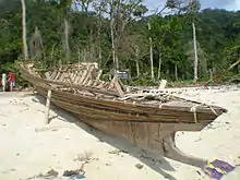
The Moken are three distinct tribes living on the Andaman Coast of Myanmar and Thailand: the Moken of the Mergui archipelago, the Moklen of the Phang Nga Province, and the Urak Lawoi living from the Phuket province south to the Satun province. With Austronesian roots, their languages (Moken, Moklen, Urak Lawoi'), culture, and lifestyle are unique, and they have a history of peaceful coexistence with mainland neighbors. The Moken, proper, have a long history of living in the Mergui archipelago between Myanmar and the islands of Thailand's North Andaman coast. As sea nomads, the Moken used to spend most of their lives on traditional houseboats known as kabang,[7][8][9][10] moving from bay to bay depending on the wind and weather. The last kabang was built in 2006 and an initiative to revive the tradition started in 2018.[11]
The Moken do not have a written language and their traditions are passed on by oral lore, which helped them to survive the 2004 tsunami wiping out the villages in Ko Surin Nuea and Ko Surin Tai.[2] When the villagers saw the sea receding back from the beaches, they knew a tsunami was approaching as their ancestors have encoded the danger in a legend of the laboon or giant wave. The legend teaches that the laboon usually comes as series of waves. The mass of water receding very quickly was peculiar, and the incoming white breaker was definitely a sign of laboon as it occurred without any stirring wind or a changing sign in the sky.[12] The entire population escaped to safe higher grounds and those who were taking tourists out for snorkeling headed their boats away from the shore to avoid impact.[2][12] However, their houses and all their other belongings were completely wiped out. Only half of the boats survived the catastrophe. The community reconstructed a single village called Ao Bon Yai in Ko Surin Tai.[2]
Family connections are strong and dependable. Furthermore, the Moken language has no native words for individual possession which is reflected in a culture of sharing and giving.
Aside from ancestor worship, the Moken have no religion. In sea tribe tradition, the deceased are buried below the house of their family, alongside sea shells and other ritualistic offerings.[13] The Moken have great understanding and respect for their environment and natural resources. In past times, the Moken people were subsistence hunter-gathers, trading shells, sea cucumbers, and fish for rice and other necessities. They use 83 plant species for food, 33 for medicinal purposes, 53 for construction of huts, boats and tools, and 54 species for other purposes.[8]
National Park
| Year | Visitors[5] |
|---|---|
| 2012 | 16,711 |
| 2013 | 17,086 |
| 2014 | 11,055 |
| 2015 | 15,563 |
| 2016 | 52,517 |
Mu Ko Surin National Park (Thai: อุทยานแห่งชาติหมู่เกาะสุรินทร์, romanized: oot yaan haeng chaa dti muu gaw soo ri noht) encompasses the islands and their surrounding waters. The park was gazetted as the 30th national park of Thailand on 9 July 1981[1] and expanded on 6 July 2007.[14] The park covers an area of 88,282 rais ~ 141.25 square kilometres (54.54 sq mi).[1] Of the protected area, 108 km2 (42 sq mi) or 76 percent is ocean.
Visiting the park can be done either as day trips with speedboats from Khao Lak and Khura Buri Pier or by multiple day cruises. The entrance fee can be paid at the Surin Islands Visitor Center in Khura Puri, the headquarters at Chong Kaad Bay of Ko Surin Nuea, or to the staff at Richelieu Rock. At Ko Surin Nuea it is possible to camp at Mai Ngam beach or rent one of the few accommodations at Chong Kaad Bay. Other than the Moken village and park premises, there are no other buildings on the islands. Except for the Moken village and campsite, most of the land areas in the islands are off limits to visitors. In high season around 450–800 people visit the park every day. The park is open 15th October to 15th May and may close earlier depending on weather conditions.[2]
Flora and fauna
Primary rain forest covers most area of the park. Beach forest can be found in beach areas where Barringtonia and Cerbera odollam abound. Mangrove forest can be found in the mud and brackish water of Mae Yai Bay.[3]
Surveys have found:[3]
- Ninety-one types of birds including 57 local species. Others are migrating species.
- Twenty-two mammal species including 12 types of bats.
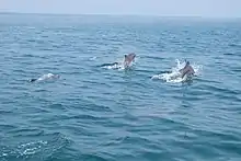
- Marine mammals such as Bryde's whales.[15]
- Seven species of reptiles such as Asian water monitors, Clouded monitors, skinks, reticulated pythons, and the endemic Surin bent-toed gecko.
- Sea turtles still nest on the Surin islands, with two species coming ashore to lay their eggs, critically endangered hawksbill and green turtles. In the early-1990s some rare olive ridley turtles were spotted.
The national park has been designated an Important Bird Area (IBA) by BirdLife International because it supports populations of the near-threatened Nicobar pigeon and Beach stone-curlew, the vulnerable Large green pigeon, as well as several species that are nationally threatened or near-threatened in Thailand, including Green imperial pigeon, Pied imperial pigeon and Orange-breasted green pigeon.[16]
Recreational diving
More than 260 species of reef fish, 68 species of coral, 48 species of nudibranch, and 31 species of shrimp were recorded in the national park.[2]
The best time for diving is from December to April with dry conditions, minimum wind and an average water temperature at around 29 °C (84 °F). All dive sites are only accessible by boat. While sightings of large pelagic species like manta ray and whale shark[17] are rare, February to April is the best time to spot them.[2] Due to marine conservation initiatives diving is not allowed in certain areas of the national park.[2]
| Name | Type | Coordinate | Average depth |
|---|---|---|---|
| Richelieu Rock | reef | 9°21′48″N 98°1′19″E | 20 m (66 ft) |
| Ko Khai | slope | 9°22′16″N 97°52′13″E | 15 m (49 ft) |
| Pak Kaad | night | 9°22′47″N 97°52′40″E | 10 m (33 ft) |
| Turtle Ridge | slope | 9°23′21″N 97°52′55″E | 15 m (49 ft) |
| Prebens Platon | reef | 9°23′22″N 97°49′22″E | 20 m (66 ft) |
| Suthep Bay | slope | 9°24′55″N 97°50′56″E | 15 m (49 ft) |
| Ko Glang | slope | 9°25′5″N 97°49′44″E | 15 m (49 ft) |
| Hin Kong | rocky islet | 9°25′40″N 97°53′15″E | 10 m (33 ft) |
| Ko Chi | slope | 9°28′23″N 97°54′16″E | 15 m (49 ft) |
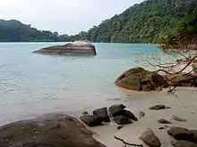
Richelieu Rock is a solitary limestone pinnacle standing from around 30 to 35 m (98 to 115 ft) depth with its peak right below the sea surface at low tide and home to some of the largest marine life species in Thailand.[2] It is referred to one as one of the ten best dive spots in the world.[18][19]
See also
References
- "Mu Koh Surin National Park". Tourism Authority of Thailand. Retrieved 2023-07-11.
- "Surin Islands". Thai National Parks. 2019. Retrieved 2023-07-12.
- "Mu Ko Surin National Park". Department of National Parks (DNP). Archived from the original on 2016-06-10.
- "Similan Islands geology". Khao Lak Explorer. Retrieved 2023-07-13.
- "ข้อมูลสถิติ อุทยำนแห่งชำติ สัตว์ป่ำ และพันธุ์พืช" [STATISTICAL DATA National Parks, Wildlife and Plant] (PDF). Department of National Parks (in Thai). 2016. Retrieved 2023-07-16.
- Indigenous people and parks: The Surin Islands Project (PDF). Identifying participatory development options for the Moken of the Surin Islands. Paris: UNESCO Office of the Regional Advisor for Culture in Asia and the Pacific. 2001. Retrieved 2023-07-11.
- Hinshiranan, Narumon (2001-01-01). "Kabang: the living boat". Techniques & Culture. 35–36: 499–507. doi:10.4000/tc.310. ISSN 1952-420X. Retrieved 2023-07-14.
- Arunotai, Narumon (2006-12-20). "Moken Traditional Knowledge: An Unrecognised Form of Natural Resources Management and Conservation". International Social Science Journal. 58 (187): 139–150. doi:10.1111/j.1468-2451.2006.00599.x.
- Holtzman, Bob (2012-10-13). "The Moken Kabang". Indigenous Boats. Retrieved 2023-07-14.
- Ivanoff, Jacques; Bountry, Maxime. "Moken sea-gypsies" (PDF). Lampi Marine National Park. International Scientific Network Tanaosri. Retrieved 2023-07-14.
- "Build a New Moken Kabang Houseboat". Projects. North Andaman Network Foundation. 2018-06-27. Retrieved 2023-07-14.
- Arunotai, Narumon (July 2008). "Saved by an Old Legend and a Keen Observation: The Case of Moken Sea Nomads in Thailand". In Shaw, Rajib; Baumwoll, Jennifer (eds.). Indigenous Knowledge for Disaster Risk Reduction: Good Practices and Lessons Learned from Experiences in the Asia-Pacific Region (PDF). Bangkok: United Nations Office for Disaster Risk Reduction. pp. 72–78. Retrieved 2023-07-12.
- Na Thalang, Jeerawat (2017-02-12). "Sea gypsies turning the tide". Bangkok Post. Retrieved 2023-07-12.
- "ขยายเขตอุทยานแห งชาติหมู เกาะสุรินทร ในท องที่ตําบลเกาะพระทองอําเภอคุระบุรีจังหวัดพังงาพ" [Expanding the area of the Surin Island National Park in Nai Thong at Ko Phra Thong Subdistrict, Khura Buri District, Phang Nga Province] (PDF). Royal Gazette, Volume 124, Section 31 (in Thai). Bangkok. 2007-07-06. pp. 36–39. Archived from the original (PDF) on 2022-11-11. Retrieved 2023-07-15.
Inclusion of 3,907 rais ~ 6.2512 km2 (2.4136 sq mi) around Richelieu Rock.
- "ทะเลไทยสมบูรณ์ พบวาฬบรูด้า! เยือนหมู่เกาะสุรินทร์" [Perfect Thai sea. Meet Bryde's whale! Visit Surin Islands]. thairat (in Thai). 2015-01-18. Retrieved 2023-07-14.
- "Important Bird Area factsheet: Mu Ko Surin". BirdLife Data Zone. BirdLife International. 2023. Retrieved 2023-07-11.
- Noreen (2010-02-22). "13. Best Whale Shark Dive – Richelieu Rock, Koh Tachai, Thailand". Best Dive Sites: Top 15 Dives to Experience Before You Die. Scuba. Retrieved 2023-07-13.
- "Best Scuba Diving in the World: 10 Top Locations". ScubaPro. 2021-07-23. Retrieved 2023-07-13.
- "Top 10 Dives: World's Best Places for Scuba Diving". SCUBAtravel. 2023-07-07. Retrieved 2023-07-13.
External links
![]() Mu Ko Surin National Park travel guide from Wikivoyage
Mu Ko Surin National Park travel guide from Wikivoyage