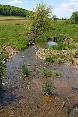
Susquehecka Creek
Susquehecka Creek, once known as Freeburg Creek or Freeburg Run, is a tributary of Middle Creek in Snyder County, Pennsylvania, in the United States. It is approximately 5.4 miles (8.7 km) long and flows through Washington Township and Freeburg.[1] The watershed of the creek has an area of 9.44 square miles (24.4 km2). The creek has one named tributary, Dry Run. Part of Susquehecka Creek is impaired by sedimentation/siltation due to agriculture. A number of bridges have been constructed over the creek. Its watershed is designated as a Coldwater Fishery and a Migratory Fishery.
| Susquehecka Creek | |
|---|---|
 Susquehecka Creek looking upstream in its lower reaches | |
| Physical characteristics | |
| Source | |
| • location | Pleasant Valley in Washington Township, Snyder County, Pennsylvania |
| • elevation | 614 ft (187 m) |
| Mouth | |
• location | Middle Creek in Washington Township, Snyder County, Pennsylvania |
• coordinates | 40°46′28″N 76°54′09″W |
• elevation | 436 ft (133 m) |
| Length | 5.4 mi (8.7 km) |
| Basin size | 9.44 sq mi (24.4 km2) |
| Basin features | |
| Progression | Middle Creek → Penns Creek → Susquehanna River → Chesapeake Bay |
| Tributaries | |
| • left | Dry Run |
Course

Susquehecka Creek begins in a broad valley known as Pleasant Valley, in Washington Township. It flows east-northeast for a few miles alongside Pennsylvania Route 35, crossing it twice. As the creek nears Freeburg, it receives the tributary Dry Run from the left and turns northeast, entering Freeburg. After a few tenths of a mile, it turns east-southeast for a short distance and reenters Washington Township before turning east-northeast, continuing to follow Pennsylvania Route 35. After more than a mile, the creek arrives at the end of Pleasant Valley and reaches its confluence with Middle Creek.[1]
Susquehecka Creek joins Middle Creek 3.22 miles (5.18 km) upstream of its mouth.[2]
Hydrology
A reach of Susquehecka Creek is designated as an impaired waterbody. The cause of the impairment is siltation/sedimentation and the likely source of the impairment is grazing-related agriculture.[3]
Geography and geology
The elevation near the mouth of Susquehecka Creek is 436 feet (133 m) above sea level.[4] The elevation of the creek's source is 614 feet (187 m) above sea level.[1] The creek is a relatively small stream.[5]
In the middle of the 20th century, the channel of Susquehecka Creek was significantly modified and relocated. The modifications included straightening, adding dikes, cleaning, and widening and deepening.[6] A. Joseph Armstrong's book Trout Unlimited's Guide to Pennsylvania Limestone Streams described the creek as "yet another alleged limestone stream in an area with little appeal".[5]
Watershed
The watershed of Susquehecka Creek has an area of 9.44 square miles (24.4 km2).[2] The mouth of the creek is in the United States Geological Survey quadrangle of Freeburg. However, its source is in the quadrangle of Dalmatia.[4]
Flooding has been known to occur along Susquehecka Creek and its tributary Dry Run in the borough of Freeburg.[7]
The designated use of Susquehecka Creek is aquatic life.[3]
History
Susquehecka Creek was entered into the Geographic Names Information System on August 2, 1979. Its identifier in the Geographic Names Information System is 1189115.[4] The creek is also known as Freeburg Creek or Freeburg Run.[4][8] The former variant name appears in a 1953 United States Geological Survey map.[9] However in 1965, USGS agent William L. Cain discovered that no locals had heard of the name "Freeburg Creek", and that every local he spoke to—including the then-mayor of Freeburg, a postmaster, a farmer, and a retired man—knew the creek as "Susquehecka Creek", though only two people he spoke to knew how to spell it.[10] The name "Susquehecka Creek" had already been in use for many years by 1965.[10]
A concrete tee beam bridge carrying State Route 2003 over Susquehecka Creek was built in 1937, 1 mile (1.6 km) south of Freeburg and is 42.0 feet (12.8 m) long. A prestressed box beam or girders bridge carrying Pennsylvania Route 35 across the creek was built in 2008, 3 miles (4.8 km) east of Fremont and is 64.0 feet (19.5 m) long.[11] This bridge replaced a steel bridge built over the creek in 1952.[12]
Biology
The drainage basin of Susquehecka Creek is designated as a Coldwater Fishery and a Migratory Fishery.[8] The creek has been officially proposed for future listing as a wild trout stream.[13]
See also
- Kern Run, next tributary of Middle Creek going upstream
- List of rivers of Pennsylvania
References
- United States Geological Survey, The National Map Viewer, retrieved December 29, 2015
- Pennsylvania Gazetteer of Streams (PDF), November 2, 2001, pp. 57, 138, retrieved December 29, 2015
- United States Environmental Protection Agency, 2006 Waterbody Report for Susquehecka Creek, retrieved December 29, 2015
- Geographic Names Information System, Feature Detail Report for: Susquehecka Creek, retrieved December 29, 2015
- A. Joseph Armstrong (2000), Trout Unlimited's Guide to Pennsylvania Limestone Streams, Stackpole Books, p. 222, ISBN 9780811729444
- Pennsylvania Forests and Waters, Volumes 2–4, 1950, p. 136
- Snyder County Hazard Mitigation Plan Appendix C – Hazard Profile (PDF), p. 18, retrieved December 29, 2015
- "§ 93.9m. Drainage List M. Susquehanna River Basin in Pennsylvania Susquehanna River", Pennsylvania Code, retrieved December 29, 2015
- Geographic Names Information System, Variant Citation, retrieved December 29, 2015
- William L. Cain (August 1965), PA_1189115_001_Susquehecka Creek_frm_1965.pdf, retrieved December 29, 2015
- Snyder County, retrieved December 29, 2015
- "Traffic Advisory: Route 35 bridge", The Daily Item, May 6, 2008, retrieved December 29, 2015
- Pennsylvania Fish and Boat Commission, Streams Officially Proposed for Wild Trout Designation, archived from the original on January 30, 2016, retrieved December 29, 2015