Tôn Đức Thắng Boulevard
Tôn Đức Thắng Boulevard (Vietnamese: Đường Tôn Đức Thắng) is a thoroughfare in District 1, downtown Ho Chi Minh City, Vietnam.
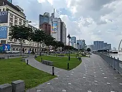
 Ton Duc Thang Boulevard and the Ba Son Bridge in 2023 | |
| Native name | Đường Tôn Đức Thắng (Vietnamese) |
|---|---|
| Owner | Ho Chi Minh City |
| Location | District 1, Ho Chi Minh City |
| Nearest metro station | Ba Son metro station |
| Coordinates | 10°46′39″N 106°42′25″E |
| North end | Lê Duẩn Boulevard |
| Major junctions |
|
| South end | Hàm Nghi Boulevard & Khánh Hội Bridge |
The boulevard stretches from Lê Duẩn Boulevard to the north end of the Khánh Hội Bridge, with more than half of its length running along the west bank of the Saigon River.[1][2]
History
Present-day Tôn Đức Thắng Boulevard incorporates Saigon's two colonial streets.
The first street stretched from the river bank to the former citadel of Saigon. On 17 February 1859, the French troops took this street to capture Saigon. In 1865, it was named boulevard de la Citadelle. This name lasted until 1901, when the artery was renamed boulevard Luro. The boulevard runs alongside the Saigon Naval Shipyard and the buildings of the naval barracks in its southeastern part.[3]: 312 In 1955, the boulevard was renamed Cường Để Boulevard by the government of South Vietnam. Following the 1963 South Vietnamese coup d'état, the Cộng Hòa Barracks were demolished and Cường Để Boulevard was extended as far as Hồng Thập Tự Street (present-day Nguyễn Thị Minh Khai Street). In August 1975, it became part of the Đinh Tiên Hoàng Boulevard, which then stretched from Saigon River all the way to Bà Chiểu, the provincial capital of former Gia Định province.[4]
The second street stretched along the bank of Saigon River, it is further separated into two parts, then known as the quais, by the Place Rigault de Genouilly (present-day Mê Linh Square). The southern quai had its name changed quite often throughout the French colonial period. Initially quai de Donnai, the name of the quai was successively changed to quai Napoléon (1865), quai du Commerce (1870), quai Francis Garnier (1896) and finally quai le Myre de Vilers (1920).[3]: 300 The northern quai, located immediately in front of the naval barracks, also had two different names, initially quai Primauguet and then changed to quai d'Argonne in 1920.[3]: 87 In 1955, both quais were given a single name, Bạch Đằng Quay (Bến Bạch Đằng), by the South Vietnamese government.[4]
In 1980, the Bạch Đằng Quay and a section of Đinh Tiên Hoàng Boulevard (former Cường Để Boulevard) was named Tôn Đức Thắng Boulevard to commemorate the second president of Vietnam, Tôn Đức Thắng, who passed earlier that year.[4][5]
See also
- Mê Linh Square
- Ba Son Bridge
References
- "Map of Ho Chi Minh City". HCM CityWeb.
- Kraas, Frauke; Le, Hoa Thu; Diez, Javier Revilla; Garschagen, Matthias (2023). Mega-Urban Development and Transformation Processes in Vietnam: Trends, Vulnerability and Policy Options. Lit Verlag. p. 100.
- Baudrit, André (1943). Guide historique des rues de Saigon (in French). Saigon: S.I.L.I.
- Sài Gòn xưa & nay (in Vietnamese). Tạp chí xưa & nay. 2007. pp. 183–184.
- Trung Sơn (2018-02-19). "Năm đại lộ đầu tiên của Sài Gòn xưa". VnExpress (in Vietnamese).
External links
 Media related to Ton Duc Thang Boulevard, Ho Chi Minh City at Wikimedia Commons