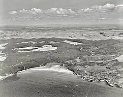
Tākou Bay
Tākou Bay is a bay and rural community in the Far North District and Northland Region of New Zealand's North Island, beside the Tākou River.[1] Tākou Bay is an official name, gazetted on 16 July 2020.[2]
Tākou Bay | |
|---|---|
 Tākou Bay in 1973 | |
| Country | New Zealand |
| Region | Northland Region |
| District | Far North District |
| Ward | Bay of Islands/Whangaroa |
| Electorates | |
| Government | |
| • Territorial Authority | Far North District Council |
| • Regional council | Northland Regional Council |
| Population | |
| • Total | 162 |
| Postcode | 0295 |
The local Tākou Marae is a meeting place for the Ngāpuhi hapū of Ngāti Tautahi, Ngāti Tūpango and Ngāti Whakaeke, and the Ngāpuhi and Ngāpuhi / Ngāti Kahu ki Whaingaroa hapū of Ngāti Rēhia.[3] It includes Te Whetū Marama meeting house.[4] The Mātaatua canoe ended its journey in Tākou Bay.[5] Piakoa burial caves in the cliffs above the bay are wāhi tapu on the New Zealand Heritage List.[6] In 2019 Māori Development Minister, Nanaia Mahuta, announced up to $2.3m investment with Te Rūnanga o Whaingaroa in housing at Tākou Bay for repairs and affordable homes.[7]
The 2018 census SA1 7000135, covering the area around Tākou Bay Road, had 129 Europeans, 30 Māori and 3 Asians.[8]
References
- Hariss, Gavin. "Takou Bay, Northland". topomap.co.nz. NZ Topo Map.
- "Tākou Bay". gazetteer.linz.govt.nz. Retrieved 15 July 2023.
- "Te Kāhui Māngai directory". tkm.govt.nz. Te Puni Kōkiri.
- "Māori Maps". maorimaps.com. Te Potiki National Trust.
- Rāwiri Taonui (8 February 2005). "Rāwiri Taonui, 'Canoe traditions - Canoes of the northern tide'". Te Ara - the Encyclopedia of New Zealand. Retrieved 15 July 2023.
- "Two Northland sites of significance to Māori listed". Waatea News: Māori Radio Station. 8 April 2021. Retrieved 15 July 2023.
- "Minister congratulates Te Rūnanga O Whaingaroa on initiative". www.scoop.co.nz. 4 February 2019. Retrieved 15 July 2023.
- "Population density & diversity in New Zealand". StatsNZ. 2018.