Table Mountain (Wicklow)
Table Mountain is a 702-metre (2,303 ft) peak in the southern section of the Wicklow Mountains range in Ireland. With a prominence of only 16 metres (52 ft), it is only listed in a few of the recognised categories of mountains in Ireland; it is the 110th–highest peak on the Vandeleur-Lynam Irish scale.[2][3] Table Mountain is at the apex of a horseshoe-shaped "boggy" massif with its larger neighbours, Camenabologue 758 metres (2,487 ft) and Conavalla 734 metres (2,408 ft) that sit at the head of the Glenmalure valley; all three peaks lie close to the "central spine" of the range as it runs from Kippure in the north, to Lugnaquillia in the south.[3][4] There is no recorded Irish language name for Table Mountain, and it has no connection with Table Mountain in Cape Town, South Africa.[5]
| Table Mountain | |
|---|---|
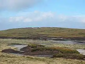 Flat summit of Table Mountain | |
| Highest point | |
| Elevation | 702 m (2,303 ft)[1] |
| Prominence | 16 m (52 ft)[1] |
| Listing | Arderin Beg, Vandeleur-Lynam |
| Coordinates | 53.01716°N 6.481634°W |
| Geography | |
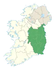
 Table Mountain Location in Ireland | |
| Location | Wicklow, Ireland |
| Parent range | Wicklow Mountains |
| OSI/OSNI grid | T019972[1] |
| Topo map | OSi Discovery 56 |
| Geology | |
| Mountain type | Granite with microcline phenocrysts[1] |
Plane crash
On the afternoon of 7 March 1957, between 12:30 and 12:45pm, a Percival Provost training plane crashed into the slopes of Table Mountain in thick fog resulting in the death of its pilot, an Irish Air Corps lieutenant.[6] The pilot was 21-year-old Patrick L. O'Connor, of Clooneyquin, Castlerea, County Roscommon.[6] The plane had left Baldonnel Aerodrome, Dublin at 11:15am that morning for an intended training flight over the counties of Offaly and Wicklow, but was believed to have lost contact with the control tower shortly after departure.[6] The explosion was heard by forestry workers on nearby Conavalla Mountain who rushed to assist and were able to raise the alarm.[6] Parts of the aircraft, which were scattered over an area of 80 yards, still remained on the slopes of the mountain as of 2010.[7]
Bibliography
- Fairbairn, Helen (2014). Dublin & Wicklow: A Walking Guide. Collins Press. ISBN 978-1848892019.
- MountainViews Online Database (Simon Stewart) (2013). A Guide to Ireland's Mountain Summits: The Vandeleur-Lynams & the Arderins. Collins Books. ISBN 978-1-84889-164-7.
- Dillion, Paddy (1993). The Mountains of Ireland: A Guide to Walking the Summits. Cicerone. ISBN 978-1852841102.
See also
References
- "Table Mountain". MountainViews Online Database. Retrieved 15 July 2019.
- Simon Stewart (October 2018). "Vandeleur-Lynams: Irish mountains of 600+m with a prominence of 15m". MountainViews Online Database.
- Mountainviews, (September 2013), "A Guide to Ireland's Mountain Summits: The Vandeleur-Lynams & the Arderins", Collins Books, Cork, ISBN 978-1-84889-164-7
- Dillion, Paddy (1993). The Mountains of Ireland: A Guide to Walking the Summits. Cicerone. ISBN 978-1852841102.
Walk 10: Ballineddan Mountain, Slievemaan, Lugnaquillia, Camenabologue East Top, Camenabologue, Table Mountain, Lobawn
- Paul Tempan (February 2012). "Irish Hill and Mountain Names" (PDF). MountainViews.ie.
- (staff writer) (8 March 1957). "Air Corps Pilot Dies in Plane Crash". The Irish Times.
- "Table Mountain (Sliabh an Tábla)". mountainviews.ie. Retrieved 24 March 2023.
| British Isles |  | |
|---|---|---|
| Scotland | ||
| Outside Scotland | ||
| England | ||
| Ireland | ||
| County tops | ||
.jpg.webp)
External links
- MountainViews: The Irish Mountain Website, Table Mountain
- MountainViews: Irish Online Mountain Database
- The Database of British and Irish Hills , the largest database of British Isles mountains ("DoBIH")
- Hill Bagging UK & Ireland, the searchable interface for the DoBIH