Teressa Island
Teressa (Teressa language: Luroo, Hindi: तेरेस्सा, also called Tarasa Dwip) is one of the Nicobar Islands, India.
Native name: Luroo | |
|---|---|
 Teressa op | |
| Geography | |
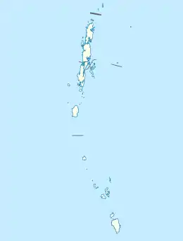
| Location | Bay of Bengal |
| Coordinates | 8.27°N 93.13°E |
| Archipelago | Nicobar Islands |
| Adjacent to | Indian Ocean |
| Total islands | 1 |
| Major islands |
|
| Area | 86.5 km2 (33.4 sq mi)[1][2] |
| Length | 5.3 km (3.29 mi) |
| Width | 19.6 km (12.18 mi) |
| Coastline | 52.8 km (32.81 mi)[2] |
| Highest elevation | 250 m (820 ft)[2] |
| Administration | |
| District | Nicobar |
| Island group | Nicobar Islands |
| Subdivisions of India | Nancowry Subdivision |
| Largest settlement | Bengali (pop. 400) |
| Demographics | |
| Population | 1934 (2014) |
| Pop. density | 22.35/km2 (57.89/sq mi) |
| Ethnic groups | Hindu, Nicobarese |
| Additional information | |
| Time zone | |
| PIN | 744301 |
| Telephone code | 03192 |
| ISO code | IN-AN-00[3] |
| Official website | www |
| Literacy | 84.4% |
| Avg. summer temperature | 32.0 °C (89.6 °F) |
| Avg. winter temperature | 28.0 °C (82.4 °F) |
| Sex ratio | ♂/♀ |
| Census Code | 35.638.0002 |
| Official Languages | Hindi, English, Tamil Teressa (regional) |
History
When Austria claimed Nicobar Islands as a colony (1778-1784) on the assumption that Denmark had abandoned its claim (1754/56-1868), they named Teressa after the Austrian Arch-duchess Maria Theresia. Extensive damage to the island's flora and fauna occurred following the 2004 Indian Ocean earthquake and tsunami.
Geography
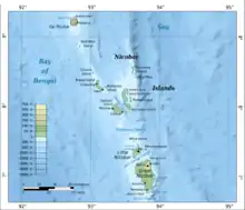
Teressa lies west of the neighboring island of Camorta and northwest of Katchal. The smaller island known as Chowra is to the north and Bompoka lies to the east. The northern portion of the island has elevations reaching 87 meters. The island has a surface area of 101.26 km2.
Demography
The Indian National Census of 2011 showed the island to have a population of 1,934, and the largest settlements were: Bengali (354), Kalasi (335), and Minyuk[4] (305).
Image gallery
Safed Balu Beach
The Safed Balu Beach (white sand beach) is situated at the east opposite to Bampoka Island.
 Map
Map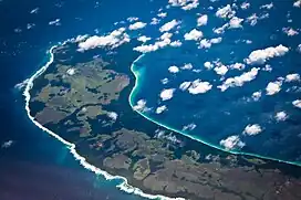 Aerial View
References
- "Islandwise Area and Population - 2011 Census" (PDF). Government of Andaman.
- "Islands of Andaman and Nicobar Islands (India)". UN. Retrieved 9 July 2014.
- Registration Plate Numbers added to ISO Code
- "Minyuk Pincode 744303". Retrieved 19 March 2023.
- Tehsils
 Andaman and Nicobar Islands travel guide from Wikivoyage