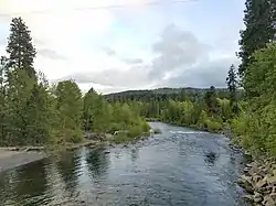
Teanaway River
The Teanaway River is a tributary of the Yakima River, in the U.S. state of Washington. It flows into the Yakima River near Cle Elum. The Teanaway River is part of the Columbia River basin, being a tributary of the Yakima River, which is tributary to the Columbia River. The river's name comes from Sahaptin, possibly /tyawnawí-ins/, "drying place".[3]
| Teanaway River | |
|---|---|
 | |
| Location | |
| Country | United States |
| State | Washington |
| County | Kittitas |
| Physical characteristics | |
| Source | Cascade Range |
| • coordinates | 47°15′24″N 120°53′54″W[1] |
| • elevation | 2,280 ft (690 m)[2] |
| Mouth | Yakima River |
• coordinates | 47°10′1″N 120°50′9″W[1] |
• elevation | 1,820 ft (550 m)[2] |
Course
The Teanaway River begins near the confluence of its three forks, the North Fork, Middle Fork, and West Fork Teanaway. These forks all begins at elevations above 5,000 feet (1,500 m) in the Cascade Range northeast of Cle Elum Lake. The confluence is located in the vicinity of the Teanaway Community Forest.[4]
After its forks joins, the Teanaway River curves through the Teanaway River Valley, flowing east, then west, then south to join the Yakima River near Teanaway.
References
- https://edits.nationalmap.gov/apps/gaz-domestic/public/summary/1526965 Teanaway River], USGS, GNIS
- Google Earth elevation for GNIS coordinates.
- Bright, William (2004). Native American placenames of the United States. University of Oklahoma Press. p. 484. ISBN 978-0-8061-3598-4. Retrieved 11 April 2011.
- "Teanaway Community Forest Map" (PDF). Washington State Department of Natural Resources. Retrieved May 26, 2020.
External links
- U.S. Geological Survey Geographic Names Information System: Teanaway River, USGS, GNIS
- U.S. Geological Survey Geographic Names Information System: North Fork Teanaway River, USGS, GNIS
- U.S. Geological Survey Geographic Names Information System: West Fork Teanaway River, USGS, GNIS
- U.S. Geological Survey Geographic Names Information System: Middle Fork Teanaway River, USGS, GNIS