Gibeah

Gibeah (/ˈɡɪbiə/; Hebrew: גִּבְעָה Gīḇəʿā; Hebrew: גִּבְעַת Gīḇəʿaṯ) is the name of three places mentioned in the Hebrew Bible, in the tribes of Benjamin, Judah, and Ephraim respectively.[1]
Gibeah of Benjamin is the most commonly mentioned of the places. In the Book of Judges, it is the main setting to the story of the Benjaminite War. Later, in the Book of Samuel, it is mentioned as the first capital of the united Kingdom of Israel under king Saul. Gibeah of Benjamin is generally identified with Tell el-Fūl in northern Jerusalem.[2]
Etymology
Gibeah is a Hebrew word meaning "hill" (Hebrew: גִּבְעָה, romanized: Giv'ah).[1]
| ḳbꜥw[3][4] in hieroglyphs | |||
|---|---|---|---|
| Era: New Kingdom (1550–1069 BC) | |||
Gibeah of Benjamin
Biblical narrative
Gibeah in the tribe of Benjamin was the location of the infamous rape and murder of the Levite's concubine, and the resulting Battle of Gibeah (Judges 19–21). Israel’s first king, King Saul, reigned here for 22 years (1 Samuel 8–31). According to PEF explorer C.R. Conder, the name may have applied to a district as well as to a town, since the neighboring town of Ramah is said to have been "in Gibeah."[5]
It is mentioned several times in later prophetic writings.[6] Also known as Gibeat (Joshua 18:28). The name "Gibeah of God" (גִּבְעַת הָאֱלֹהִים, Give'at-elohim)[7] may also refer to this Gibeah.
Perhaps to avoid confusion with other places named Gibeah, this location is also called "Gibeah of Benjamin" (גִּבְעַת בִּנְיָמִין, Give'at Binyamin)[8] and "Gibeah of Saul" (גִּבְעַת שָׁאוּל, Give'at Sha'ul).[9] The latter name is also used by the modern neighborhood Givat Shaul, which however is located in a different location.
In extra-biblical sources
According to Josephus, the 10th Roman Legion camped near Gabaothsaul in its assault on Jerusalem in 70 CE.[10]
Identification with Tell el-Ful
This Gibeah is generally identified with Tell el-Fūl (Arabic: تلّ الفول, lit. 'mound of fava beans'),[11] a hill in the northern reaches of modern Jerusalem, on the outskirts of the Pisgat Ze'ev and Shuafat neighborhoods.[12][13] This location is 3 miles (4.8 km) north of ancient Jerusalem, along the watershed ridge at 2,754 feet (839 m) above sea level. According to Josephus, Gabaothsaul was located about 30 stadia north of Jerusalem, which would have roughly corresponded with the location of Tell el-Fūl.[10]
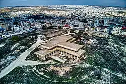
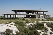
King Hussein of Jordan began construction on his royal palace at Tell el-Ful, but construction was halted when the Six-Day War broke out. Since Israel won the war, King Hussein's palace was never finished and now all that remains is the skeleton of the building.

Alternatively, Gibeah may have been where Jaba' now stands (9.12 kilometres (5.67 mi) north of Jerusalem), a view held by biblical scholar Edward Robinson[14] and C. Umhau Wolf.[15] However, Jaba is now widely identified with the biblical city of Geba[16][17]
Israel Finkelstein also challenged the identification with Tell el-Fūl.[18]
Archaeology
Tell el-Ful was first excavated in 1868 by Charles Warren, while C.R. Conder described the remains in 1874. William F. Albright led his first excavation from 1922 to 1923, and returned for a second season in 1923. His work was published in 1960. P.W. Lapp conducted a six-week salvage excavation in 1964. According to Kenneth Kitchen, "Upon this strategic point was found an Iron I occupation replaced (at an interval) by a fortress ("I"), subsequently refurbished ("II"), and then later in disuse. The oldest level may reflect the Gibeah of Judges 19–20. The excavations by Albright, checked by Lapp, would favor the view that it was Saul who built the first fortress, later repaired by him or David. The first fort (quadrangular) had at least one rectangular corner-tower at its southwest angle; it may have had others at the other corners, but no traces were detected."[19]
The site was once more inhabited around the start of the Hellenistic period, and its wall was once more in service. The citadel underwent repairs as well in the second century BCE. At the end of the second century BCE, the site was abandoned.[20]
Gibeah of Judah and Ephraim
Gibeah of Judah was a city in the tribal inheritance of Judah (Joshua 15:57); cities mentioned in nearby verses included Zanoah and Halhul. C. R. Conder identifies this Gibeah with Jab'a.[21]
Gibeah of Ephraim was a city in the tribal inheritance of Ephraim, "the Gibeah of Phinehas" (Joshua 24:33); Eleazar, the son of Aaron, was buried here. Possibly Awarta.
See also
References
- Dictionary - AlHaTorah.org
- Aharoni, Y. (1979). The Land of the Bible: A Historical Geography (2 ed.). Philadelphia: Westminster Press. p. 435. ISBN 0664242669. OCLC 6250553. (original Hebrew edition: 'Land of Israel in Biblical Times - Historical Geography', Bialik Institute, Jerusalem (1962))
- Gauthier, Henri (1928). Dictionnaire des Noms Géographiques Contenus dans les Textes Hiéroglyphiques. Vol. 5. p. 169.
- Wallis Budge, E. A. (1920). An Egyptian hieroglyphic dictionary: with an index of English words, king list and geological list with indexes, list of hieroglyphic characters, Coptic and Semitic alphabets, etc. Vol. II. John Murray. p. 1043.
- Conder, C.R. (1879). Tent Work in Palestine. A Record of Discovery and Adventure. Vol. 2. London: Richard Bentley & Son (published for the Committee of the PEF). p. 111. OCLC 23589738.
- Hosea 5:8, 9:9, 10:9 and Isaiah 10:29
- 1 Samuel 10:5
- 1 Samuel 13:2, 13:15, 14:16
- 1 Samuel 11:4, 15:34; Isaiah 10:29
- Josephus, The Jewish War 5.2.1. (5.47)
- Nancy Lapp, Ful, Tell el-, Oxford Encyclopedia of Archaeology in the Near East (1997).
- LaMar C. Berrett, Discovering the World of the Bible
- H.B. Tristram, The Land of Israel: A Journal of Travels in Palestine, London 1865, p. 169
- Robinson, E.; Smith, E. (1841). Biblical Researches in Palestine, Mount Sinai and Arabia Petraea: A Journal of Travels in the year 1838. Vol. 3. Boston: Crocker & Brewster. p. 122 (2nd appendix).
- C. Umhau Wolf (1971), The Onomasticon of Eusebius of Pamphili, § 335 (d). This view is based on the premise that Gabatha of Saul (I Samuel 10:26) was known in Eusebius' time, and if it had been Tell al Ful, as claimed by historical geographers, they are still left to explain why no Byzantine remains were found at the site.
- Guerin, 1869, pp. 67-69
- Conder and Kitchener, 1883, SWP III, p. 9
- Israel Finkelstein (2011). "Tell el-Ful revisited: The Assyrian and Hellenistic periods (with a new identification)". Palestine Exploration Quarterly. 143 (2): 106–118. doi:10.1179/003103211x12971861556918.
- Kenneth Kitchen, On the Reliability of the Old Testament (Grand Rapids: Eerdmans), p. 97.
- Halpern-Zylberstein, Marie-Christine (1990-03-22), Davies, W. D.; Finkelstein, Louis (eds.), "The Archeology of Hellenistic Palestine", The Cambridge History of Judaism (1 ed.), Cambridge University Press, doi:10.1017/chol9780521219297.002, ISBN 978-0-521-21929-7, retrieved 2023-03-19
- H.B. Tristram, Bible Places: or, The Topography of the Holy Land: a Succinct Account of All the Places, Rivers, and Mountains…, London 1897, p. 83; Conder & Kitchener, SWP (vol. 3), London 1883, p. 53.
Further reading
- Albright, W.F. (1971). The Archaeology of Palestine
- Arnold, P. (1992). "Gibeah", Anchor Bible Dictionary
- Lapp, N. (1997). "Tell el-Ful", Oxford Encyclopedia of Archaeology in the Near East
- Regev, Eyal (1999). "Josephus on Gibeah: Versions of a Toponym". The Jewish Quarterly Review. University of Pennsylvania Press. 89 (3/4): 351–359. JSTOR 1455028.
- Sinclair, L.A. (1960). An Archaeological Study of Gibeah