Tikitere Graben
The Tikitere Graben is a intra-rift graben in the North Island of New Zealand that contains the Ohau Channel which drains Lake Rotorua into Lake Rotoiti but with a minimal drop.
| Tikitere Graben | |
|---|---|
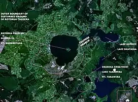
 NASA image identifying the Tikitere Graben relative to the Rotorua Caldera. South of the lake that fills much of the apparently circular caldera is the town of Rotorua. The western portion of Lake Rotoiti is in the graben which connects to its eastern portion which are eruption craters in filled now with water. | |
 Tikitere Graben | |
| Floor elevation | 280 m (920 ft)[1] |
| Length | 15 km (9.3 mi) approximately |
| Width | 5 km (3.1 mi) approximately |
| Geology | |
| Type | intra-rift garben |
| Age | 240,000 years |
| Geography | |
| Country | New Zealand |
| State/Province | Bay of Plenty |
| Coordinates | 38°02′36″S 176°20′07″E |
| River | Ohau Channel |
Geography
The Ohau Channel ultimately allows both lakes to drain into the Kaituna River through drainage that is also associated with the graben. The Tikitere Graben also is associated with the geothermal tourist attraction of Hell's Gate and the western aspects of Lake Rotoiti.
Geology
The tectonically subsiding Tikitere Graben at 2mm/year[1] has destroyed the Rotorua Caldera rim at this point so providing the natural outlet for Lake Rotorua.[1] The graben is an intra-rift graben in the Taupo Rift and is delimited by two unnamed active faults in the current active NZ fault database (#3590 and #2210). [2] Historically some suspect that the graben did not exist after the caldera forming Mamaku eruption of approximately 240,000 years ago[3] when the lake filled to a maximum elevation of 414 m (1,358 ft) above sea level. Drainage of this initial lake is not known but could have been through the Tikitere Graben always or perhaps initially through the Hemo Gap to the south of the present town of Rotorua.[1] Whatever at some stage drainage of Rotorua Lake through the Tikitere Graben became established but prior to the Rotoiti eruption in the Ōkataina Volcanic Centre of 47,400 years ago[4] drainage may not have been through what seems to be a very young Kaituna River gorge.[1] It is known that after the Rotoiti eruption Lake Rotorua rose to an elevation of just over 370 m (1,210 ft) and at some stage later drained through the Tikitere Graben back into what is now Lake Rotoiti scoring an approximately 1 km (0.62 mi) wide, 60 m (200 ft) deep channel in the western arm of Lake Rotoiti to reach initially the eastern Rotoiti craters of the Haroharo caldera in the Ōkataina Volcanic Centre and then on to the sea.[1] By about 9500 years ago dome building activity in the eastern Haroharo portions of the Ōkataina Volcanic Centre had raised Lake Rotoiti to a maximum elevation of 294 m (965 ft) so it started flowing down the Kaituna River and in due course further graben sinking resulted in both lakes having a near common outlet level of today's 280 m (920 ft).[1]
References
- Manville, V.; Hodgson, K. A.; Nairn, I. A. (2007). "A review of break‐out floods from volcanogenic lakes in New Zealand". New Zealand Journal of Geology and Geophysics. 50 (2): 131–150. doi:10.1080/00288300709509826. S2CID 129792354.
- "GNS Surface Traces of Onshore Active Faults at a Scale of 1:250,000".
- Bégué, F.; Deering, C. D.; Gravley, D. M.; Kennedy, B. M.; Chambefort, I.; Gualda, G. A. R.; Bachmann, O. (2014). "Extraction, Storage and Eruption of Multiple Isolated Magma Batches in the Paired Mamaku and Ohakuri Eruption, Taupo Volcanic Zone, New Zealand". Journal of Petrology. 55 (8): 1653–1684. doi:10.1093/petrology/egu038.
- Flude, S.; Storey, M. (2016). "40Ar/39Ar age of the Rotoiti Breccia and Rotoehu Ash, Okataina Volcanic Complex, New Zealand, and identification of heterogeneously distributed excess 40Ar in supercooled crystals". Quaternary Geochronology. 33: 13–23. doi:10.1016/j.quageo.2016.01.002.