Tille (river)
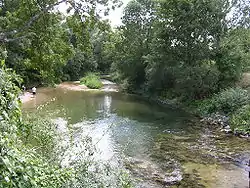
The Tille (French pronunciation: [tij]) is an 83-kilometre-long (52 mi) river of eastern France (département Côte-d'Or), a right tributary of the Saône.[1] It is formed by the confluence of three small streams near Cussey-les-Forges, on the Plateau of Langres. The Tille flows south through the following towns: Til-Châtel, Arc-sur-Tille (east of Dijon) and Genlis. The Tille flows into the Saône in Les Maillys, 8 kilometres (5 mi) south of Auxonne.
| Tille | |
|---|---|
 | |
.png.webp) | |
| Location | |
| Country | France |
| Physical characteristics | |
| Mouth | |
• location | Saône |
• coordinates | 47°7′35″N 5°20′45″E |
| Length | 83 km (52 mi) |
| Basin features | |
| Progression | Saône→ Rhône→ Mediterranean Sea |
In 2022, the river dried up following severe drought conditions.[2]
References
- Sandre. "Fiche cours d'eau - La Tille (U12-0400)".
- Corbet, Sylvie; Garriga, Nicolas (August 12, 2022). "Experts Warn Europe's Drought Could be Worst In 500 Years". Time. Retrieved August 12, 2022.
This article is issued from Wikipedia. The text is licensed under Creative Commons - Attribution - Sharealike. Additional terms may apply for the media files.