Tipton Station
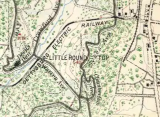
Tipton Station was a Gettysburg Battlefield trolley stop of the Gettysburg Electric Railway for passenger access to Crawford's Glen to the north,[1] Devil's Den (west), and Tipton Park (east). The station was established during the 1894 construction of the end of the trolley line and was near the Devil's Den trolley siding, south of the trolley's Warren Avenue crossing, and northeast of the Plum Run trolley bridge. An uphill trail led southwest to Big Round Top with its 1895 Observation Tower, and the "Slaughter Pen Path and Steps" were built to Devil's Den.

Tipton Park
Tipton Park was an 1894 trolley park with a tintype photographic studio and food stand on private Slaughter Pen land purchased in March 1892[2] by photographer William H. Tipton, an investor[3] in the 1891 Gettysburg Electric Railway Company.[4] As with Wheat-field Park to the west-northwest and Little Round Top Park (northeast), the park was a commemorative era visitor attraction for battlefield excursions such as the "Christian Endeavor Day" on July 25, 1899. The park property was one of the first trolley right-of-ways acquired by the War Department after the 1896 US Supreme Court decision in the United States v. Gettysburg Electric Ry. Co. case. The 2 tracts of 14.2 acres (0.057 km2) were deeded on December 31, 1901,[5]: 321 after a May 7 federal hearing,[6]: '01 and the "eating house" was moved to the Little/Big Round Top topographic saddle (operated by "Blind Davy" Weikert).[7] The trolley tracks were removed in 1917 after federal funding was authorized.
In 1934 a Gettysburg Parkitecture comfort station was built at the site[8] (40.116111°N 77.186667°W)[9] and a Plum Run pedestrian bridge was built to it from Devil's Den. In 2004, artifacts associated with Tipton Park were designated as historic district contributing structures (e.g., "Tipton Boundary Marker",[2] and the comfort station and its electrical line were removed c. 2008.
References
- Hamilton, Calvin (January 5, 1892). "Executive Committee Minutes of the Gettysburg Battlefield Association". Gettysburg Battlefield Memorial Association. Retrieved 2011-03-04.
May 13, 1884 … On motion, permission was granted Henry Reister to occupy the shanty at the base of Little Round Top, for the sale of refreshments, provided, that no intoxicating liquors should be sold.
- "List of Classified Structures" (Document). NPS.gov.:
RR02: "Electric Trolley Bed". Archived from the original on 2011-07-21. Retrieved 2011-03-02.[rail] trail along Plum Run at Devils Den, runs N through Rose Farm & stops near The Loop. … Pair of cut stone block abutments over Rose Run, 5' high, 25' long & approx 10' apart.
MN807: "Tipton Boundary Marker". Retrieved 2011-03-02.approximately, 7"x7"x1'. Inscribed "T" on top of marker. … rough granite with a "T" inscribed on the top. … at a corner of Tipton land purchased in March 1892 as part of the Tipton Park and photographic studio.
NPS02: "Old Slaughter Pen Path and Steps". Retrieved 2011-03-04.used by [trolley] passengers … Path and steps are now used as a Park trail. … Path runs N/S from Plum Run to Sickles Avenue.
- "The Trolley was the Cause - Tipton Said to be Its Advocate". The New York Times. July 5, 1893. Retrieved 2011-06-28.
Complaints had come to General Sickles that Tipton's money and influence are for the trolley road, …
- "Electric Railway" (Google News Archive). Gettysburg Compiler. August 4, 1891. Retrieved 2011-03-06.
- "Gettysburg National Park". United States military reservations, National cemeteries, and military parks. 1916. Retrieved 2011-04-19.
Tipton, Wm. H. and wife (2 tracts), dated December 31, 1901, conveying 14.2 acres of land. Recorded in book 55, page 524
- Gettysburg National Military Park Commission. "An Introduction to the Annual Reports of the Gettysburg National Military Park Commission to the Secretary of War". The Gettysburg Commission Reports. Gettysburg, PA: War Department.
- "Local Miscellany; Out of the Past: Twenty-Five Years Ago" (Google News Archive). Gettysburg Times. August 9, 1927. Retrieved 2013-10-23.
- "Plan $50,000 Battlefield Project Here" (Google News Archive). Gettysburg Times. July 16, 1934. Retrieved 2011-02-02.
The entrance stations … will be combination guides' stations, comfort stations and information bureaus. … The comfort stations will be erected at Devil's Den and Spangler's Spring.
(1936, 1936, 1937) - Devil's Den, Cumberland, PA (Map). Google Maps. December 2007. Retrieved 2011-06-28.