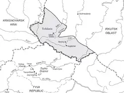
Tofalariya
Tofalariya (Russian: Тофалария) is a small cultural and historical region in Irkutsk Oblast, Russian Federation. It is located in the southwestern part of Nizhneudinsky District.[1]
Tofalariya
Тофалария | |
|---|---|
.jpg.webp) Landscape of the region at the Uda Valley. | |
 | |
 Tofalariya Location in the Far Eastern Federal District, Russia | |
| Coordinates: 53°50′N 98°15′E | |
| Country | Russian Federation |
| Federal subject | Irkutsk Oblast |
| District | Nizhneudinsky District |
| Area | |
| • Total | 21,400 km2 (8,300 sq mi) |
| Elevation | 918 m (3,012 ft) |
| Population | |
| • Total | 762 |
| • Density | 0.036/km2 (0.092/sq mi) |
| Time zone | UTC+8 |
The main town is Alygdzher, with a population of 526 inhabitants. Tofalariya is located in the Eastern Sayan mountains. The main river is the Uda.[2]
History
In 1939, at the time of the USSR, Tofalariya was part of the Tofalar National Region, a Soviet administrative division with a total surface of 29,000 km2 (11,000 sq mi) which was disbanded in 1950.[3][4] The indigenous people of this little mountainous region are the Tofalar, a much reduced, formerly nomadic people group speaking the Tofa language.[5]
See also
References
- Google Earth
- "Топографска карта N-47, G; M 1:1 000 000 - Topographic USSR Chart (in Russian)". Retrieved 14 June 2023.
- РСФСР. Административно-территориальное деление. — 3. — М.: Информационно-статистический отдел при секретариате Президиума ВС РСФСР, 1945. — С. 136—139. — 504 с. — 15 000 экз
- Административно-территориальное деление Союза ССР. — М.: Власть Советов, 1931. — p. 172
- Akiner, Shirin (1986). Islamic Peoples of the Soviet Union (with an appendix on the non-Muslim Turkic peoples of the Soviet Union). London: Routledge. pp. 428–431. ISBN 0-7103-0025-5.
External links
 Media related to Tofalaria at Wikimedia Commons
- tofalaria.ru
This article is issued from Wikipedia. The text is licensed under Creative Commons - Attribution - Sharealike. Additional terms may apply for the media files.