Burwood Highway
Burwood Highway is a major transportation link with Melbourne's eastern suburbs. It begins in the suburb of Kooyong, Melbourne at the junction of the Monash Freeway as Toorak Road between Monash Freeway and Warrigal Road, and finishes in Belgrave, Victoria in the Dandenong Ranges.[2] The highway is considered a major link for people who live in the Dandenong Ranges and acts as one of the major feeder roadway in the area along with Canterbury Road, Ferntree Gully Road, EastLink and Wellington Road.
Burwood Highway | |
|---|---|
 | |
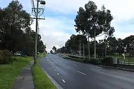
| Burwood Highway, Burwood East | |
 West end East end | |
| Coordinates |
|
| General information | |
| Type | Highway |
| Length | 30 km (19 mi)[1] |
| Route number(s) |
|
| Former route number | (Upper Ferntree Gully–Belgrave) |
| Major junctions | |
| West end | Hawthorn, Melbourne |
| |
| East end | Belgrave, Melbourne |
| Location(s) | |
| Major settlements | Burwood, Burwood East, Wantirna South, Ferntree Gully, Upwey, Belgrave |
| Highway system | |
Route
Burwood Highway is a primary route between Melbourne and the eastern suburbs, and the area around Belgrave. It begins at its junction with CityLink and Monash Freeway as Toorak Road, a four lane single carriageway, which is often clogged with heavy traffic, as well as trams travelling along the roadway for some of the route. Just east of the intersection with Warrigal Road, the highway widens to become a six-lane dual carriageway highway, with a dedicated central median for trams tracks, carrying the Route 75 service to Vermont South, as Burwood Highway. A few kilometres before Belgrave, the highway narrows again to a single carriageway.
Main destinations beyond Belgrave, along Belgrave-Gembrook Road:
- Emerald (Shire of Cardinia) (46 km (28.6 mi) from Melbourne) (11 km (6.8 mi) from Belgrave)
- Cockatoo (Shire of Cardinia) (52 km (32.3 mi) from Melbourne) (17 km (10.6 mi) from Belgrave)
- Gembrook (Shire of Cardina) (60 km (37.3 mi) from Melbourne) (25 km (15.5 mi) from Belgrave)
History
The passing of the Highways and Vehicles Act of 1924[3] through the Parliament of Victoria provided for the declaration of State Highways, roads two-thirds financed by the State government through the Country Roads Board (later VicRoads). The Burwood Highway was declared a State Highway in the 1959/60 financial year,[4] from Warrigal Road in Burwood via Vermont South, to Upper Ferntree Gully (for a total of 12.5 miles (20.1 km)); before this declaration, these roads were referred to as Burwood Road and (Main) Fern Tree Gully Road.[4] The highway was eventually extended a further 4.0 km (2.5 mi) east along Monbulk Road to Belgrave in June 1990,[5] and west along Toorak Road from Warrigal Road to the South Eastern Arterial at Kooyong in October 1993,[6] however this last section was still known (and signposted) as Toorak Road. The tram line was extended 1.7 km (1.1 mi) along the central median through Burwood East from Middleborough Road to Blackburn Road in July 1993.[7]
The Burwood Highway was signed as Metropolitan Route 26 between Burwood and Belgrave in 1965; with Victoria's conversion to the newer alphanumeric system in the late 1990s, the section between Upper Ferntree Gully and Belgrave was replaced by route C412.
The passing of the Road Management Act 2004[8] granted the responsibility of overall management and development of Victoria's major arterial roads to VicRoads: in 2004, VicRoads re-declared the Burwood Highway (Arterial #6750) from the Monash Freeway in Hawthorn to Belgrave-Gembrook Road in Belgrave.[2]
Major intersections
| LGA | Location[1][2] | km[1] | mi | Destinations | Notes |
|---|---|---|---|---|---|
| Stonnington | Kooyong–Malvern–Hawthorn tripoint | 0 | 0.0 | Western terminus of declared highway; continues west as Toorak Road | |
| Single-point urban interchange | |||||
| Boroondara | Hawthorn | 0.1 | 0.062 | Auburn Road – Kew | |
| Hawthorn East | 0.4 | 0.25 | Tooronga Road – Malvern | ||
| Camberwell | 1.3 | 0.81 | |||
| 2.6 | 1.6 | Glen Iris Road – Glen Iris | |||
| 3.2 | 2.0 | No right turn from Camberwell Road to Toorak Road westbound | |||
| Boroondara–Whitehorse boundary | Camberwell–Burwood boundary | 5.0 | 3.1 | Name transition: Toorak Road west, Burwood Highway east | |
| Whitehorse | Burwood | 6.2 | 3.9 | Elgar Road – Doncaster | |
| 7.1 | 4.4 | ||||
| Burwood–Burwood East boundary | 8.2 | 5.1 | |||
| Burwood East | 9.0 | 5.6 | |||
| Burwood East–Forest Hill–Vermont South tripoint | 11.5 | 7.1 | |||
| Knox | Wantirna–Wantirna South boundary | 14.9 | 9.3 | ||
| 15.4 | 9.6 | Diamond interchange | |||
| 17.6 | 10.9 | ||||
| Wantirna South | 18.8 | 11.7 | Lewis Road (north) – Wantirna South | ||
| Knoxfield–Ferntree Gully boundary | 19.7 | 12.2 | |||
| Ferntree Gully | 21.6 | 13.4 | Commercial Road (north) – Ferntree Gully | Western terminus of concurrency with Metro Route 22 | |
| 22.3 | 13.9 | Concurrency with Metro Route 5 | |||
| 22.7 | 14.1 | ||||
| 23.4 | 14.5 | Brenock Park Drive (south) – Lysterfield Selman Avenue (north) – Ferntree Gully | |||
| Knox–Yarra Ranges boundary | Upper Ferntree Gully | 25.4 | 15.8 | Route transition: eastern terminii of Metro Routes 22 and 26, western terminus of route C412 | |
| Yarra Ranges | Tecoma | 28.1 | 17.5 | Glenfern Road – Rowville | |
| Belgrave | 29.8 | 18.5 | Terrys Avenue (west) – Tecoma | Roundabout; eastern highway terminus | |
| |||||
Gallery
 Toorak Road, looking west from Tooronga Road, Hawthorn East
References
- Google (19 October 2021). "Burwood Highway" (Map). Google Maps. Google. Retrieved 19 October 2021.
- VicRoads. "VicRoads – Register of Public Roads (Part A) 2015" (PDF). Government of Victoria. pp. 1027–1028. Archived from the original on 1 May 2020. Retrieved 19 October 2021.
- State of Victoria, An Act to make further provision with respect to Highways and Country Roads Motor Cars and Traction Engines and for other purposes 30 December 1924
- "Country Roads Board Victoria. Forty-Seventh Annual Report: for the year ended 30 June 1960". Country Roads Board of Victoria. Melbourne: Victorian Government Library Service. 21 November 1960. pp. 7–8.
- "Victorian Government Gazette". State Library of Victoria. 20 June 1990. pp. 1865, 1867. Retrieved 30 December 2021.
- "Victorian Government Gazette". State Library of Victoria. 28 October 1993. pp. 2902–3. Retrieved 30 December 2021.
- "VicRoads Annual Report 1992-93". VicRoads. Melbourne: Victorian Government Library Service. 29 September 1993. p. 42.
- State Government of Victoria. "Road Management Act 2004" (PDF). Government of Victoria. Archived (PDF) from the original on 18 October 2021. Retrieved 19 October 2021.