Torit County
Torit County is an administrative region in Eastern Equatoria of South Sudan,[2] with headquarters in the town of Torit, which is also the state capital.
Torit county | |
|---|---|
 Torit county Location in South Sudan | |
| Coordinates: 4°25′N 32°34′E | |
| Country | |
| State | Eastern Equatoria |
| Headquarters | Torit |
| Government | |
| • County Commissioner | Fermo Peter Isara[1] |
| Population (2008) | |
| • Total | 99,740 |
| Time zone | UTC+2 (CAT) |
Location
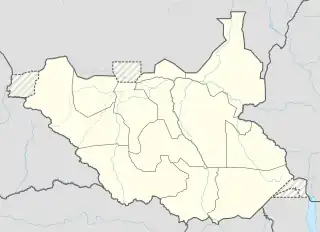
Torit County is located in Torit State, in southern South Sudan, close to the border with Kenya and Uganda . Torit is one of the tens states of South Sudan known as Eastern Equatoria state. Torit county is bordered by his neighbors county ,Lopa County to the north, Kapoeta county to the east, Ikowot county to the east south, Magwi County to the west and Juba County in the extreme northwest. (See map to the right).
The town of Torit, where the county headquarters are located, lies approximately 150 kilometres (93 mi), by road, east of Juba, the capital and largest city in South Sudan.[3] The coordinates of Torit County are: 4° 30' 0.00"N, 32° 30' 0.00"E (Latitude: 4.5000; Longitude: 32.5000).
Overview
Torit County was earlier split into 8 payams. The payams that constitute Torit County include the following:[4]
- Bur Payam
- Ifwotu Payam
- Kudo Payam
- Hiyala Payam
- Himodonge Payam
- Imurok Payam
- Nyong Payam
- Iyire Payam
The town of Torit is the headquarters of Torit County, one of the eleven counties which make up Torit State. Torit is also the capital of Torit State, one of the twenty-eight states which constitute the Republic of South Sudan. The Imatong Mountains lie partly in the southern part of Torit County. In April 2016, the county was divided into 3 counties, with 2 new counties of Torit East and Torit West being carved out of the county.[5]
History
Torit County was formed in 1934 by the merging of the districts of Teretenya and Opari. Opari was the district administrative headquarters for the regions inhabited by the Lotuko (Otuho), Madi and Acholi ethnic groups. Torit county was adversely affected by both the Second Sudanese Civil War and by the activities of the Lord's Resistance Army. As late as 2006, a significant portion of its population was still internally displaced within South Sudan.
Population
The 2008 Sudanese census estimated the population of Torit County at approximately 99,740[6] Although these results were disputed by the South Sudanese authorities, they are the only recent figures available and form a basis on which newer studies can be based.
In April 2016, the state was divided into 3 counties with 2 new counties called Torit East and Torit West being carved out of it.[5]
See also
References
- Peter Lokale Nakimangole (14 August 2016). "New Public Leaders' Appointments In Imatong Counties". Gurtong. Retrieved 20 August 2016.
- "Torit: Speaker And Deputy Elected, Commissioners, Administrators Sworn In". Gurtong. 4 March 2016. Retrieved 14 August 2016.
- Estimated Road Distance Between Juba And Torit With Maap
- Partial Listing of the Payams of Torit County Archived 2012-03-26 at the Wayback Machine
- Nakimangole, Peter Lokale (22 April 2016). "Additional Counties In Torit And Kapoeta States Established". Gurtong. Retrieved 14 August 2016.
- 2008 South Sudanese Population By County
External links
| Counties |  | |
|---|---|---|
| Principal towns | ||
| Airports | ||
| Rivers | ||
| Mountains | ||
| Communities | ||