Torngat Mountain tundra
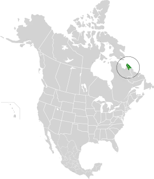
The Torngat Mountain tundra ecoregion (WWF ID: NA1118) covers the Torngat Mountains on the northeastern tip of the Labrador Peninsula where the provinces of Quebec and Newfoundland and Labrador meet. The mountains feature glacially carved U-shaped valleys and deep fjords. The vegetation over most of the territory is that of arctic tundra (lichen, moss, sedges and grasses), herbaceous cover, or bare rock. The region supports seasonal polar bears, black bears, and caribou. The Atlantic coast is on the Atlantic Flyway for migratory birds.[1][2][3][4]
| Torngat Mountain tundra | |
|---|---|
 Korok River in Kuururjuaq National Park | |
 Ecoregion territory (in green) | |
| Ecology | |
| Realm | Nearctic |
| Biome | Tundra |
| Geography | |
| Area | 32,363 km2 (12,495 sq mi) |
| Country | Canada |
| Coordinates | 58.75°N 64.5°W |
Location and description
The Torngat Mountains are the southernmost range of the Arctic Cordillera, a chain of mountain ranges that reach 2,500 km to the northern point of Ellsmere Island. The Torngat Mountains for a peninsula between Ungava Bay on the west and the Atlantic Ocean on the east. The ecoregion is only 100 km wide, and 300 km north to south. Rising from sea level, the mean elevation is 490 metres (1,610 ft) meters, and the highest point 1,498 metres (4,915 ft). The west side is continuous permafrost; the eastern (Atlantic coast side) has discontinuous permafrost. The bordering ecoregion on the west and south is the Eastern Canadian Shield taiga.
Climate
The climate of the ecoregion is Tundra climate (Köppen climate classification ET), a local climate in which at least one month has an average temperature high enough to melt snow (0 °C (32 °F)), but no month with an average temperature in excess of 10 °C (50 °F).[5][6] Precipitation averages 300-700 mm/year; average temperature in the winter is −16.5 °C (2.3 °F) and 4 °C (39 °F) in the summer.[1]
Flora and fauna
Ground cover in the region is 68% moss and lichen, 15% herbaceous cover, and less than 1% evergreen forest. The remainder is bare rock, sparse vegetation or open water.[3] The areas with mixed evergreen and deciduous shrubs tend to be on sheltered, south-facing slopes. Where tundra and open forest meet there is often a transition zone of birch/willow thickets.[4]
Mammals are mostly small species, but there are noteworthy populations of polar bears (Ursus maritimus) denning in the region seasonally, an unusual community of tundra-dwelling black bears (Ursus americanus), and a herd of Torngat caribou.[4]
Protected areas
Over 41% of the ecoregion is officially protected.[3] These protected areas include:
References
- "Torngat Mountain tundra". World Wildlife Federation. Retrieved March 21, 2020.
- "Map of Ecoregions 2017". Resolve, using WWF data. Retrieved September 14, 2019.
- "Torngat Mountain tundra". Digital Observatory for Protected Areas. Retrieved August 1, 2020.
- "Torngat Mountain tundra". The Encyclopedia of Earth. Retrieved August 28, 2020.
- Kottek, M., J. Grieser, C. Beck, B. Rudolf, and F. Rubel, 2006. "World Map of Koppen-Geiger Climate Classification Updated" (PDF). Gebrüder Borntraeger 2006. Retrieved September 14, 2019.
{{cite web}}: CS1 maint: multiple names: authors list (link) - "Dataset - Koppen climate classifications". World Bank. Retrieved September 14, 2019.