Township (Quebec)
A township (French: canton) in Quebec, Canada, is a cadastral division of the land. The township system was implemented by the British government to facilitate the granting of public lands for settlement by populations of European background, particularly Loyalists from the American Revolution. Townships were initially also a unit of local government, but that is no longer the case. Townships are now used solely for land description and do not have a governmental function.
In the Quebec system, townships for the most part are approximately 10 miles by 10 miles square, except for those located on the banks of a navigable waterway which are 9 miles abreast and 12 miles deep.
Creation of the township system
Under the seigneurial system of land holdings in force in New France, a local lord, or "seigneur" had overall control of a large area of land. Individuals who held plots of land within the seigneury had to pay seigneurial duties to the local seigneur.
Post-conquest, the British colonial government instituted the township system of land-holding. It was based on English land law, using the tenure of "free and common socage", which did not require seigneurial levies.[1] Following the arrival of Loyalists fleeing the American Revolution, the British Parliament enacted the Constitutional Act, 1791, which introduced this form of land tenure in both Lower Canada and Upper Canada.[1][2] After the passage of the Act, the British government instructed the Governor to grant land in townships, which was subsequently set out by a proclamation of Lieutenant Governor Clarke in 1792.[3]
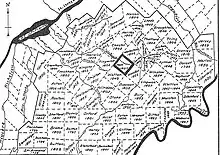
The township of Dunham was the first township established in Quebec, on February 2, 1796, in the region which came to be known as the "Eastern Townships of Lower Canada" (cantons de l'Est du Bas-Canada), as opposed to the "Western Townships of Upper Canada".[4][5] The Eastern Townships also form a historic region. Collectively, they constituted the bloc of the first townships created in what is now Quebec, before the final replacement of the seigneurial regime in 1854. The Eastern Townships include the whole of the Estrie administrative region, and parts of the administrative regions of Centre-du-Québec, Chaudière-Appalaches and Montérégie.
Abolition of seigneurial tenure
In 1854, the Parliament of the Province of Canada abolished the system of seigneurial tenure, converting all former seigneurial tenures to franc-aleu roturier.[6] The subsequent amending act provided for the creation of new townships in new regions, in addition to the existing eastern townships.[1][7] Later, several other areas were divided into townships before being settled, such as Abitibi-Témiscamingue, Saguenay-Lac-Saint-Jean, and Côte-Nord.[1]
The system today
Today, the townships no longer represent administrative divisions recognized by the Ministry of Municipal Affairs and Housing (Quebec). Only municipal townships, formed from one or more townships, such as township municipalities and united township municipalities, are recognized.[8] However, several towns and municipalities bear the name, or part of the name, of the township in which they are located, such as Amos, Granby, Joliette, Les Escoumins, North Hatley, Roberval, Thetford Mines. Others bear the name of their respective parish, composed with the name of the township where it is located: Saint-Germain-de-Grantham, Saint-Edmond-de-Grantham, Saint-Denis-de-Brompton, Saint-François-Xavier-de-Brompton, Saint-Jacques-de-Leeds, Saint-Pierre-de-Broughton.
The Quebec cadastre is still divided into townships today. According to the system of distribution of the lots, they organize, together with the provisions relating to agricultural land and protected areas, the development and location of new urbanization plans, in rural and semi-rural regions.[9] Within the urban centres, the maintenance of the current townships serves to organize the municipal development of highways and therefore, to promote respect for acquired rights relating to the ownership of lots.
On the other hand, the township system in Quebec constitutes a main premise in the attribution of the relative responsibility.
Main characteristics of the Quebec township
For the most part, townships are approximately 10 miles by 10 miles square (16 km by 16 km), except for those located on the banks of a navigable waterway which are 9 miles abreast and 12 miles deep (14 km by 19 km).[1]
Eastern Townships (Cantons de l'Est)
- Technical characteristics of the Eastern township
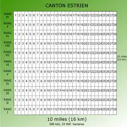
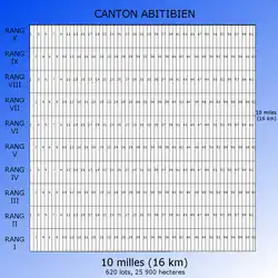
- 11 mi by 11 mi (17 km by 17 km)
- 11 rows of 28 lots
- 308 lots
- 25,900 hectares
- Technical characteristics of the batch
- 588.4 m by 1,478.6 m
- 84.9 hectares
- 5% of the land is reserved for the crown for the construction of roads
- Division
- From the Yamaska River to the Chaudière River and from the Québec-United States border to half of the Bois-Francs territory, namely:
- * Centre-du-Québec (southern half), including cities such as Drummondville;
- * Chaudière-Appalaches (southwest), including cities such as Thetford Mines;
- * Estrie (entire);
- * Montérégie (east-south-east), including cities such as Granby.
See also
References
- Ministère des Ressources naturelles, Faune et Parcs, Répertoire des cantons du Québec 2004, Annexe II: Bref historique du système du canton au Québec, pp. 51–52.
- Constitutional Act, 1791, 31 Geo. III, c. 31 (GB), s. 43.
- Alured Clarke, Esquire, Lieutenant Governor of Lower Canada, A Proclamation to such as are desirous to settle on the Lands of the Crown in the Province of Lower Canada, February 7, 1792.
- "Cantons". Ministry of Energy and Natural Resources. Archived from the original on April 19, 2019. Retrieved April 19, 2019.
- "Cantons-de-l'Est or Estrie?". Université Laval. Retrieved April 19, 2019.
- Act for the abolition of feudal rights and duties in Lower Canada, SPC 1854 (18 Vict.), c. 3, s. 14.
- Seigniorial Amendment Act of 1859, SPC 1859 (22 Vict.), c. 48.
- Commission de Toponymie du Québec - List of municipalities. Archived 2009-02-21 at the Wayback Machine
- Cadastre Act, RSQ , c. C-1.
External links
- Quebec Ministry of Natural Resources and Fauna (2004). "Directory of the cantons of Quebec 2004; Annex II, Brief history of the canton system in Quebec" (PDF). Archived from the original (PDF) on July 6, 2011. Retrieved June 19, 2009.