Trans-Amazonian Highway
The Trans-Amazonian Highway (official designation BR-230, official name Rodovia Transamazônica), was introduced on September 27, 1972. It is 4,000 km long, making it the third longest highway in Brazil. It runs through the Amazon forest and the Brazilian states of Paraíba, Ceará, Piauí, Maranhão, Tocantins, Pará and Amazonas, from the proximities of Saboeiro up until the town of Lábrea.
 | |
|---|---|
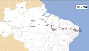 Map of BR-230 (paved portion shown in red)[1] | |
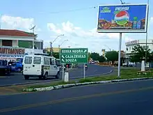 Trans-Amazonian highway within the city of Pombal, Paraíba. | |
| Location | |
| Country | Brazil |
| Highway system | |
History
The project was started by the military dictatorship that was in power from 1964 to 1985 out of their perceived need to guarantee control over the remote regions while encouraging economic engagement with the natural resources in the region.[2] The highway was intended to integrate these regions with the rest of the country, and with Colombia, Peru and Ecuador. Another main goal of the project was to alleviate the effects of the drought affecting the Northeast region of the country by providing a route to largely empty land in the middle of the rainforest,[3] which could be settled.[4] It was originally planned to be a fully paved highway 5200 kilometers long. However, these plans were modified following its inauguration.[5]
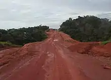
In particular, because of high construction costs and Brazil financial crisis in the late 1970s, only a part of the highway was paved, from its beginning to 200 km ahead of Marabá. The lack of a fully sealed road caused many problems. Travel on the non-paved stretches of the highway is extremely difficult during the region's rainy season between October and March.[6] In the wet season cars often get stuck in the poorly constructed road and in the dry season there are often pot holes in the dry mud roads that damage vehicles.
Construction of the highway was very challenging because of the remoteness of the site. Workers building the road were frequently isolated and without communication. Occasional visits to nearby cities provided the only outside contact. However, severe techniques and procedures that evolved during the construction of Belém-Brasília Highway (BR-153) were then used. According to DNIT, roughly 800 km of the highway is due to be paved in the next 4 years, improving transport links in the central region of Pará state. The Brazilian Government are now planning to pave the whole highway with tarmac. As of December 2009, paving was underway between the town of Ruropolis and Itaituba and north to Santarém. This will connect soy plantations with overland trucking routes to the south of Brazil. The road has been left untouched however at points further west of Itaituba, at times narrowing to roughly 2 meters wide.
Access to the construction sites was mostly accomplished by small airplanes using temporary airstrips and boats. Today construction vehicles can be seen traversing the road east and west bringing dirt and gravel to prepare for paving operations.[7]
In 2019 the Brazilian government announced that it was seeking to privatize major sections of BR-230 in an attempt to pave more sections of the road.[8]
In September of 2022, the Brazilian government finished restoration on a paved 33.3 Kilometer section of BR-230 located in the arid northern Tocantins between Aguiarnópolis and Trevo de Nazaré. There are still many sections of the road in the Amazon that remain unpaved entirely.[9]
Characteristics
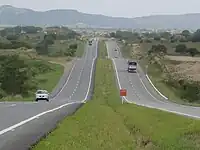
The BR-230 or Transamazônica is a transversal highway, considered the third longest highway in Brazil, with 4260 km in length, that connects the port city of Cabedelo in Paraíba with the municipality of Lábrea, in Amazonas, cutting through some of the main cities from Brazil. It also serves as a link with port areas in the state of Pará, such as Port of Santarém; Marabá, Altamira and Itaituba. It also connects with ports on the Northeast coast, like Suape Port. In Paraíba it represents the main axis of movement of people and goods between its municipalities, having as reference the port of Cabedelo and the cities of João Pessoa, Campina Grande, Patos, Pombal, Sousa and Cajazeiras, the largest economic centers in the state. It crosses the soil of Paraíba for 521 km, with good traffic conditions up to the border with the state of Ceará.[10][11][12]
The 147.6 km long section between Cabedelo, where its milestone 0 is located, and Campina Grande, passing through Grande João Pessoa and other municipalities, was doubled under the FHC government. Additional duplication is expected between the municipalities of Campina Grande and Cajazeiras.[13][14][15]
Designed to better integrate the north of Brazil with the rest of the country, it was inaugurated on August 27, 1972, still unfinished and there are several sections to be paved. Initially designed to be an 8,000-kilometer-long paved highway, connecting the north and northeast regions of Brazil with Peru and Ecuador, it has not undergone major changes since its inauguration. Later, the project was modified to 4,977 km to Benjamin Constant, however construction in Lábrea was interrupted, totaling 4,260 km.[16][17][18]
Deforestation and conservation
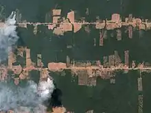
It has indirectly caused a great deal of deforestation in Brazil,[19] as roads make it easier to transport timber. Satellite images demonstrate how roads increase deforestation. Access roads branch perpendicularly off BR-230 allowing deeper penetration into the surrounding jungle areas. Originally, the roads were to open up land for agriculture by settlers, the government motto "land without men for men without land"[20] was coined to describe the development of the Amazon.
Research on the deforestation along BR-230 shows that deforestation rates vary significantly by year with noticeable spikes in deforestation in 1995 and 2004. The period of decreased deforestation following 2004 is attributed to policy change by the Brazilian government.[21] The current increase in Amazonian deforestation is attributed by some to Brazil's 38th President Jair Bolsonaro, who has publicly advocated for the economic benefits of improved infrastructure in remote areas of Brazil.[22]
Recent studies have found that soil along BR-230 contains Potentially Toxic Elements,[23] while trace metals have been found in stream sediments along BR-230.[24] These pollutants have been attributed to anthropogenic activity including gold mining and logging.
The Trans Amazonian highway, and many similar roads are a major vector of illegal deforestation and extraction activities, but they also spawn a series of unofficial offshoot road networks that further the environmental degradation of the Amazon rainforest. These subsidiary roads often become part of the official road network over time. Paved roads are considered much more potent vectors of environmental degradation as they allow more efficient transport of people and heavy equipment, they have an estimated nine times greater environmental impact than unpaved sections of road.[25] These roads pose a massive threat to native wildlife as they fracture key wildlife habitats and migration patterns.[26] The pattern of deforestation along BR-230 follows a fishbone pattern where un-official roads shoot off of the main highway to form a comb shape from which deforestation expands outwards. This is especially disruptive to local wildlife populations as it reduces the available forest to small, isolated strips. These strips eventually expand as farmers quickly deplete the nutritional value of the soil and convert the land to pasture areas for cattle, moving on to new areas of the forest to slash and burn in search of fertile land.[21]
Some experts have linked deforestation to land grabbing, attributing the expensive act of deforestation to the possibility of owning said land in the future.[26] Parts of the road located in protected areas should in theory see less deforestation on account of the lower chance of obtaining legal ownership, but the Bolsonaro administration has taken steps in recent years to legitimize large swaths of illegally cleared land, and to decrease funding for the enforcement of environmental policy.[27][28]
These environmental transgressions are made more concerning by the new research confirming the presence of massive deposits of sphagnum moss peat underneath the Amazon rainforest. The environmental concern that the Amazon rainforest is nearing a ‘tipping point’ [29] from where it will regress and form a dry savannah is made more pressing by the presence of this peat which sequesters vast amounts of carbon from the atmosphere, and will release it if exposed to too much oxygen. In addition, drained peat bogs are highly flammable and my start or exacerbate wildfires in the Amazon.[30]
BR-230 cuts across protected indigenous landholdings in the Amazon, causing territorial fragmentation, invasion, and violence for indigenous groups like the Arara and the Cachoeira Seca. Although the Arara and the Cachoeira Seca have now been recognized as impacted by BR-230 and now possess some tools to advocate against projects on their land, the agreements that they struck with the Brazilian government are not always upheld, with deintrusion requests being left unattended for years.[31] There are many other indigenous groups that are affected by the development of road infrastructure in the Amazon, and many of them are not as lucky as the Arara or the Cachoeira Seca and have not even been officially recognized as impacted by the highway. In fact, many indigenous groups do not have officially recognized demarcated territory and are now significantly less protected after the passing of Bill 3.729/2004 which removed the responsibility for projects to analyze and account for non-demarcated Indigenous territories.[25]
Various conservation units have been created along the route of the highway in an effort to halt deforestation or to manage forestry sustainably. In the western section from Lábrea to Humaitá, the fully protected Mapinguari National Park is south of the highway and the sustainable use Balata-Tufari National Forest is to the north.[32] East of Humaitá the Humaitá National Forest lies to the south of the highway, then the Campos Amazônicos National Park and Juruena National Park.[33]
References
- "Nova pagina 1". .transportes.gov.br. Archived from the original on 2013-11-29. Retrieved 2014-02-05.
- Silva, Ricardo Gilson da Costa; Silva, Viviane Vidal da; Mello-Théry, Neli Aparecida de; Lima, Luís Augusto Pereira (2021). "NEW FRONTIER OF EXPANSION AND PROTECTED AREAS IN THE STATE OF AMAZONAS". Mercator - Revista de Geografia da UFC. 20 (2).
- Moran, Emilio F. (2019-05-28), "Government-Directed Settlement in the 1970s: An Assessment of Transamazon Highway Colonization", The Dilemma of Amazonian Development, Routledge, pp. 297–317, doi:10.4324/9780429310041-15, ISBN 978-0-429-31004-1, S2CID 199107884, retrieved 2021-01-13
- Nigel J.H. Smith. "Brazil's Transamazon Highway Settlement Scheme" (PDF). College of Liberal Arts and Sciences, The University of Florida. Retrieved 2014-02-05.
- Canada (2 October 1980). "From Nothing to Nowhere — The Transamazonian Highway". New Internationalist. Retrieved 2014-02-05.
- "Amazon Brazil Tours". Brazil-travel-guide.com. Retrieved 2014-02-05.
- "Pacas That Go Bump in the Night". Amazonpilgrim.com. 2009-10-10. Archived from the original on 2009-10-14. Retrieved 2014-02-05.
- "UPDATE 3-Brazil seeks to privatize, pave Trans-Amazonian Highway". Reuters. 2019-01-22. Retrieved 2022-09-23.
- "Obra de restauração na BR-230 no Tocantins é concluída". Casa Civil (in Brazilian Portuguese). Retrieved 2022-09-23.
- Rodovias Transversais
- Construcción de TransAmazônica
- Transamazônica: conozca lo que ha cambiado en 45 años de construcción
- Rodovias Transversais
- Construcción de TransAmazônica
- Transamazônica: conozca lo que ha cambiado en 45 años de construcción
- Rodovias Transversais
- Construcción de TransAmazônica
- Transamazônica: conozca lo que ha cambiado en 45 años de construcción
- Skole, D.L., W.H. Chomentowski, W.A. Salas, and A.D. Nobre (1994). "Physical and Human Dimensions of Deforestation in Amazonia". BioScience. 44 (5): 314–322. doi:10.2307/1312381. JSTOR 1312381.
{{cite journal}}: CS1 maint: multiple names: authors list (link) - Archived June 25, 2012, at the Wayback Machine
- Johan, Westin (2014). Remote sensing of deforestation along the Trans-Amazonian Highway. Lunds universitet/Institutionen för naturgeografi och ekosystemvetenskap. OCLC 1001435974.
- Escobar, Herton (2020-08-07). "Deforestation in the Brazilian Amazon is still rising sharply". Science. 369 (6504): 613. doi:10.1126/science.369.6504.613. ISSN 0036-8075. PMID 32764049. S2CID 221075759.
- de Souza, Edna Santos; Fernandes, Antonio Rodrigues; de Souza Braz, Anderson Martins; Sabino, Lorena Lira Leite; Alleoni, Luís Reynaldo Ferracciú (2014-11-13). "Potentially toxic elements (PTEs) in soils from the surroundings of the Trans-Amazonian Highway, Brazil". Environmental Monitoring and Assessment. 187 (1): 4074. doi:10.1007/s10661-014-4074-1. ISSN 0167-6369. PMID 25391461. S2CID 35820750.
- Silva-Filho, Emmanoel V.; Marques, Eduardo D.; Vilaça, Monique; Gomes, Olga V.O.; Sanders, Christian J.; Kutter, Vinicius T. (October 2014). "Distribution of trace metals in stream sediments along the Trans-Amazonian Federal Highway, Pará State, Brazil". Journal of South American Earth Sciences. 54: 182–195. doi:10.1016/j.jsames.2014.04.011. ISSN 0895-9811.
- "Best-preserved part of Brazil's Amazon, home to isolated tribes, faces 'decimation'". Mongabay Environmental News. 2022-03-31. Retrieved 2022-09-23.
- "Road network spreads 'arteries of destruction' across 41% of Brazilian Amazon". Mongabay Environmental News. 2022-09-22. Retrieved 2022-09-23.
- "Brazil guts agencies, 'sabotaging environmental protection' in Amazon: Report". Mongabay Environmental News. 2021-02-01. Retrieved 2022-09-23.
- Simmons, Cynthia S.; Carrero, Gabriel Cardoso; Walker, Robert T. "The great Amazon land grab – how Brazil's government is clearing the way for deforestation". The Conversation. Retrieved 2022-09-23.
- Simmons, Cynthia S.; Carrero, Gabriel Cardoso; Walker, Robert T. "The great Amazon land grab – how Brazil's government is clearing the way for deforestation". The Conversation. Retrieved 2022-09-23.
- "Amazon Rainforest is Under Increasing Threat from Changing Land Use, Study Finds". AZoCleantech.com. 2022-04-15. Retrieved 2022-09-23.
- "With a new Consultation Protocol, the Arara people demand participation in the asphalting rules of the Transamazon Highway | ISA". Instituto Socioambiental - ISA. 2022-05-30. Retrieved 2022-09-23.
- Flona de Balata-Tufari Mapa Interativo (in Portuguese), ICMBio, retrieved 2016-06-03
- Flona de Humaitá - Mapa Interativo (in Portuguese), retrieved 2016-06-03
| Radial highways (originating from Brasília) | |
|---|---|
| North-south highways | |
| East-west highways | |
| Diagonal highways | |
| Link highways |
|