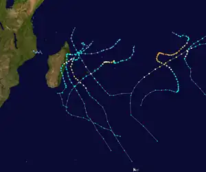
Tropical Storm Eliakim
Severe Tropical Storm Eliakim was a tropical cyclone that affected Madagascar and killed 21 people in 2018. The seventh tropical depression, sixth tropical storm of the 2017–18 South-West Indian Ocean cyclone season, and fourth tropical cyclone in 2018 to impact Madagascar,[1] Eliakim was first noted as an area of atmospheric convection south-southwest of Diego Garcia on 9 March. Developmental conditions were favorable in its vicinity, and on 14 March, both the Joint Typhoon Warning Center (JTWC) and Météo-France La Réunion (MFR) began issuing warnings on the system, with MFR designating it as Tropical Disturbance 7 and the JTWC giving it the designation 14S. On the next day, MFR upgraded the system to a moderate tropical storm, assigning it the name Eliakim. Eliakim further intensified into a severe tropical storm on 15 March, with the JTWC upgrading it to a Category 1-equivalent cyclone on the Saffir–Simpson scale on 16 March. Eliakim made landfall on Masoala at 07:00 UTC, after which MFR estimated maximum 10-minute sustained winds of 110 km/h (70 mph) within the system. Eliakim weakened into a moderate tropical storm before abruptly turning southwards and re-emerging over water on 17 March. Despite unfavorable conditions, Eliakim re-intensified into a severe tropical storm on 19 March before being downgraded back into a moderate tropical storm 6 hours later. Eliakim transitioned into a post-tropical cyclone on 20 March as it moved away from Madagascar, with the MFR last tracking the system on 22 March.
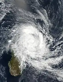 Eliakim at peak intensity on 16 March | |
| Meteorological history | |
|---|---|
| Formed | 14 March 2018 |
| Post-tropical | 20 March 2018 |
| Dissipated | 22 March 2018 |
| Severe tropical storm | |
| 10-minute sustained (MF) | |
| Highest winds | 110 km/h (70 mph) |
| Highest gusts | 155 km/h (100 mph) |
| Lowest pressure | 980 hPa (mbar); 28.94 inHg |
| Category 1-equivalent tropical cyclone | |
| 1-minute sustained (SSHWS/JTWC) | |
| Highest winds | 120 km/h (75 mph) |
| Lowest pressure | 982 hPa (mbar); 29.00 inHg |
| Overall effects | |
| Fatalities | 21 total |
| Damage | $3.21 million (2018 USD) |
| Areas affected | Madagascar, Réunion, Mayotte, Tromelin Island, Mauritius, Kenya |
| IBTrACS | |
Part of the 2017–18 South-West Indian Ocean cyclone season | |
The storm's outer bands first reached Madagascar on 15 March, and by 16 March, Eliakim made landfall on Madagascar. Thousands of people were evacuated in vulnerable areas, accompanied by advisories of heavy rainfall and strong winds. Flooding and heavy rainfall were observed in several regions, with a maximum of 388 millimeters (15.3 in) of rain being recorded in Île Sainte-Marie. Eliakim caused 21 fatalities in Madagascar, affected another 60,000, and displaced 19,439 people. Structures were also affected, with 17,228 homes, 15 roads, 27 health facilities, and 1,118 classrooms experiencing damage. Rehabilitation works in the country were estimated to cost 10 billion Malagasy ariary (US$3.21 million). Other countries also sustained impacts, with Réunion receiving swells of 5–6 meters (16–20 ft) and parts of Kenya experiencing flooding.
Meteorological history
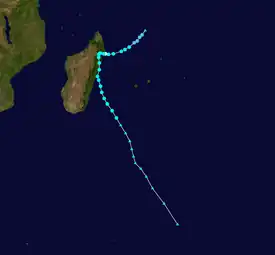
Tropical storm (39–73 mph, 63–118 km/h)
Category 1 (74–95 mph, 119–153 km/h)
Category 2 (96–110 mph, 154–177 km/h)
Category 3 (111–129 mph, 178–208 km/h)
Category 4 (130–156 mph, 209–251 km/h)
Category 5 (≥157 mph, ≥252 km/h)
Unknown
On 9 March at 10:30 UTC, the Joint Typhoon Warning Center (JTWC) began monitoring an area of atmospheric convection located approximately 335 nautical miles (620 km; 385 mi) south-southwest of Diego Garcia, assessing its development potential within the next day as low. Convection was disorganized, and conditions were marginally favorable due to a beneficial upper-level environment and strong wind shear at 25–30 knots (45–55 km/h; 30–35 mph), with sea surface temperatures in the area reaching 28–29 °C (82–84 °F).[2] Météo-France La Réunion (MFR) began monitoring the area on the next day at 12:00 UTC, assessing its risk of developing into a tropical cyclone within the next 5 days as moderate.[3] By 11 March, MFR further upgraded the system's risk of developing into a tropical cyclone within the next 5 days to high.[4] An advanced scatterometer pass on 12 March at 06:05 UTC showed an elongated low-level circulation,[5] and at 18:00 UTC, the JTWC upgraded the system's development potential within the next day to medium as wind shear decreased to 15–20 knots (30–35 km/h; 15–25 mph).[6] On 14 March at 00:00 UTC, MFR upgraded the system to a tropical disturbance, designating it as Tropical Disturbance 7.[7] The JTWC assessed that it had developed into a tropical depression at the same time, giving it the designation 14S.[8] Wind shear further decreased to 10–15 knots (20–30 km/h; 10–15 mph), and as the system continued to consolidate and organize,[9][10] MFR upgraded 7 to a tropical depression on 14 March at 12:00 UTC,[7] though the system's internal structure remained broad.[11]
At 18:00 UTC, as convective activity increased,[12] MFR upgraded 7 to a moderate tropical storm, assigning it the name Eliakim.[7] On 15 March at 00:00 UTC, the JTWC also upgraded Eliakim to a tropical storm.[8] At 06:00 UTC, MFR upgraded Eliakim to a severe tropical storm as its center was surrounded by strong convection,[7][13] the most intense of which were located in the northwestern portion of the storm.[14] Cloud tops slightly warmed and wrapping bands of convection tightened into the circulation over the next few hours, with favorable radial outflow negating the effects of moderate vertical wind shear.[13][15] A well-defined eye appeared on microwave imagery on 16 March at approximately 02:00 UTC,[16] though it was large and ragged.[17] Eliakim continued over favorable environmental conditions,[18] and at 06:00 UTC, the JTWC upgraded Eliakim to a Category 1-equivalent cyclone on the Saffir–Simpson scale, estimating maximum 1-minute sustained winds of 120 km/h (75 mph).[8] At 07:00 UTC, Eliakim made landfall on the Masoala Peninsula.[19] MFR assessed that Eliakim had peaked in intensity at 12:00 UTC, estimating maximum 10-minute sustained winds of 110 km/h (70 mph) and a minimum barometric pressure of 980 hPa (28.94 inHg),[7] with the JTWC downgrading it to a tropical storm at the same time.[8] The motion of Eliakim slowed down due to high terrain over the area[20] and became almost stationary,[21] with deep convective bands having weakened and collapsed as the system continued inland.[22] Eliakim passed over the Antongil Bay before moving slightly to the north after it moved back inland. Its cloud tops experienced significant warming, though the system's internal structure remained unaffected.[23] Convection near the system's center became relatively shallow, though conditions remained favorable despite still being inland, with low vertical wind shear and favorable outflow channels.[24]
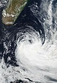
On 17 March at 00:00 UTC, MFR downgraded Eliakim to the equivalent of a moderate tropical storm, though it was classified as an overland depression by MFR.[7] At 12:00 UTC, Eliakim abruptly turned to the south as convection continued to wane near the center.[25] The storm's motion slowly sped up[26] as land interaction severely impacted its structure,[27] and at 21:00 UTC, Eliakim re-emerged over water, tracking into favorable conditions for further development. Sea surface temperatures in the area were at 28–29 °C (82–84 °F).[28] The system slowly organized over the next day as its convective structure began to improve; however, its interaction with land still hindered convective intensification.[29] Conditions gradually became unfavorable for intensification[30] as the circulation became partially exposed,[31] cloud tops warmed,[32] convection moved further from the center,[33] and wind shear increased to 25 knots (45 km/h; 30 mph).[30] Despite this, convective activity continued,[34] and on 19 March at 18:00 UTC, MFR upgraded Eliakim to a severe tropical storm.[7] However, convective activity then began to decrease and move closer to the storm's center,[35] and 6 hours later, on 20 March at 00:00 UTC, MFR downgraded Eliakim to a moderate tropical storm.[7] Conditions continued to worsen as sea surface temperatures dropped to 25 °C (77 °F),[36] and at 06:00 UTC, MFR assessed that Eliakim transitioned into a post-tropical depression,[7] as advanced scatterometer data showed an elongated circulation,[37] with rainfall also ceasing on the storm's northern side.[38] At the same time, the JTWC assessed that Eliakim transitioned into a subtropical cyclone.[8] On 22 March at 12:00 UTC, MFR assessed that it had transitioned into an extratropical cyclone, and 6 hours later, at 18:00 UTC, MFR stopped tracking the system.[7]
Preparations and impact
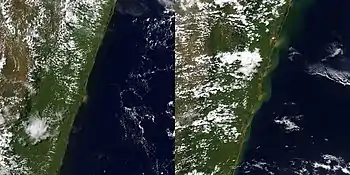
Madagascar
On 15 March, Météo Madagascar issued a red alert for areas in the central-eastern and northern parts of Madagascar due to heavy rains and strong winds, also issuing yellow cyclone alerts for the regions of Alaotra-Mangoro, Analanjirofo, Atsinanana, Diana, Sava, Sofia, and the district of Tsaratanana.[39] Four teams were deployed by the Bureau National de Gestion des Risques et Catastrophes to Antalaha, Île Sainte-Marie, Maroantsetra, and Soanierana Ivongo on the same day.[40] The Copernicus Programme's Emergency Management Service was activated on 16 March,[41] with red cyclone alerts being issued by Météo Madagascar for the regions of Alaotra-Mangoro, Analanjirofo, Atsinanana, Sava, and the districts of Bealanana, Befandriana-Nord, and Mandritsara. Red alerts were also issued by the agency for the northern and east-central parts of Madagascar due to heavy rains and strong winds. On the same day, hundreds of people in northeast Madagascar were evacuated,[42] with 800 people in Sambava becoming displaced.[43] By 18 March, between 2,500[44] and 6,000 people were evacuated.[45] At 13:00 UTC (16:00 EAT), a red alert was issued for the region of Vatovavy-Fitovinany due to heavy rains accompanied by occasional gale-force winds. As Eliakim moved away from the country, blue alerts were also issued for the regions of Amoron'i Mania, Analamanga, Betsiboka, Boeny, Bongolava, Diana, Haute Matsiatra, Itasy, Sava, Sofia, and Vakinankaratra.[46] Authorities warned of landslides and floods in several regions, also advising against sea travel.[47] On 19 March, a red alert was issued by Météo Madagascar for southeastern Madagascar due to strong winds.[48]
The outer bands of Eliakim reached northeastern Madagascar on 15 March.[49] Portions of the district of Ambatondrazaka were partially flooded, which prompted evacuations.[39] Surface observations in Antalaha recorded sustained winds of 60 knots (110 km/h; 70 mph) on 16 March at 12:00 UTC.[24] On 17 March, Air Madagascar canceled six flights due to bad weather.[50] By 18 March, severe floods were observed in Maroantsera, with less severe floods being observed in Ambilobe and Mandritsara.[44] At 06:00 UTC (09:00 EAT), a red alert was issued for the Matitanana River due to water levels reaching 6.3 meters (21 ft), surpassing the alert level of 5 meters (16 ft).[46] Heavy rains in the northern areas of the country ended after 48 hours on the same day.[51] 388 millimeters (15.3 in) of rainfall was recorded in Île Sainte-Marie, 356 millimeters (14.0 in) in Nosy Be, 319 millimeters (12.6 in) in Mananjary, and 206 millimeters (8.1 in) in Mahanoro.[52] To aid in assessing damages, an inter-agency team flew over affected areas on 19 March and 26 March.[53] Access to the most severely affected areas was hindered due to road damage,[54] with flooding also isolating several villages.[55] The immediate effects of Eliakim ceased on 20 March as it moved away from Madagascar; water levels in the Matitanana River rose further to 7 meters (23 ft).[56] On the same day, Malagasy President Hery Rajaonarimampianina visited the district of Ambilobe to provide relief and assistance.[57] Moderate flooding was recorded in Brickaville and Nosy Be, along with wind damage to the districts of Antalaha and Mananara Avaratra.[58] 21 people were killed, with 19,439 people becoming displaced,[59] 60,000 people having been affected, and hundreds of reported injuries. 15 roads were damaged, along with 27 health facilities, which disrupted the healthcare of 50,000 people.[53][60] Rehabilitation works were estimated to reach 10 billion Malagasy ariary (US$3.21 million) in cost.[61] 17,228 homes were damaged,[62] and 43,000 people became unable to access clean water.[63] 1,118 classrooms were damaged, which along with losses of school supplies, affected 54,000 students.[53] Strong floods were mainly recorded in the regions of Alaotra-Mangoro, Analanjirofo, Atsinanana, Sava, and Sofia,[64] with the main harvest season from May–June experiencing reduced productivity due to flooding.[65] Using satellite data, a study estimated that 26 percent of rice fields along with 67 percent of farms with other crops were flooded;[66] clove crops were also damaged in Analanjirofo.[67] Communications were disrupted in some parts of northeastern and eastern Madagascar.[1] Landslides were generated by rainfall on saturated soil,[68] with at least six landslides being reported on the Route nationale 2,[69] five more having occurred between Ranomafana and Marolambo,[70] and several more on the Route nationale 5, the Route nationale 31, and the Route nationale 32.[71]
Elsewhere
On 17 March, 430 firefighters were mobilized in Réunion to aid with rescues.[72] An orange alert was issued by MFR for the southwestern portion of Réunion due to strong winds on 19 March.[48] Waves reaching 5–6 meters (16–20 ft) affected the island, impacting coastal roads[73] and forcing the closure of lanes close to shore.[74] Several areas recorded gusts above 100 kilometers per hour (62 mph), with Maïdo recording 151 kilometers per hour (94 mph) and Colimaçons recording 110 kilometers per hour (68 mph).[75][76] Takamaka recorded rainfall of 756 millimeters (29.8 in) accumulated over 6 days, with Grand Îlet recording 350 millimeters (14 in) of rainfall within a day and Hauts de Ste-Rose recording 228.8 millimeters (9.01 in) of rainfall within 3 hours.[77]
Within 6 hours in Mayotte, 67.2 millimeters (2.65 in) of rainfall was recorded in Mzouazia, 37.2 millimeters (1.46 in) in Pamandzi, 23 millimeters (0.91 in) in Dembeni, and 21.5 millimeters (0.85 in) in Coconi.[78][79] Eliakim caused landslides on 18 March; it affected voters during an ongoing election.[80]
Enhanced rainfall over Kenya associated with Eliakim[81] caused flooding in vulnerable areas.[82]
Tromelin Island recorded 10-minute sustained winds of 45 knots (85 km/h; 50 mph) on 15 March.[13]
Cloud bands under the influence of Eliakim brought cloudy skies to Mauritius.[83]
See also
References
- "Rapid Response Fund No. 3/2014 – Cyclone Eliakim Emergency Response in Madagascar" (PDF). ACT Alliance. 11 April 2018. p. 1. Retrieved 28 June 2021.
- "Significant Tropical Weather Advisory for the Indian Ocean Reissued from 091030Z-091800Z March 2018". Joint Typhoon Warning Center. 9 March 2018. Archived from the original on 12 March 2018. Retrieved 9 May 2021.
- "Bulletin for Cyclonic Activity and Significant Tropical Weather in the Southwest Indian Ocean 2018/03/10 at 12:00 UTC" (PDF). Météo-France La Réunion. 10 March 2018. Retrieved 2 July 2021.
- "Bulletin for Cyclonic Activity and Significant Tropical Weather in the Southwest Indian Ocean 2018/03/11 at 12:00 UTC" (PDF). Météo-France La Réunion. 11 March 2018. Retrieved 2 July 2021.
- "Bulletin for Cyclonic Activity and Significant Tropical Weather in the Southwest Indian Ocean 2018/03/12 at 12:00 UTC" (PDF). Météo-France La Réunion. 12 March 2018. Retrieved 2 July 2021.
- "Significant Tropical Weather Advisory for the Indian Ocean from 121800Z-131800Z March 2018". Joint Typhoon Warning Center. 12 March 2018. Archived from the original on 13 March 2018. Retrieved 9 May 2021.
- "Eliakim: 13 March 2018 to 2018-03-22". Météo-France La Réunion. Retrieved 9 May 2021.
- "2018 Southern Hemisphere Best Track Data". Joint Typhoon Warning Center. Retrieved 9 May 2021.
- "Tropical Cyclone Formation Alert 140300". Joint Typhoon Warning Center. 14 March 2018. Archived from the original on 14 March 2018. Retrieved 9 May 2021.
- "Tropical Cyclone Forecast Warning Number 1 for Tropical Disturbance 7". Météo-France La Réunion. 14 March 2018. Archived from the original on 14 March 2018. Retrieved 9 May 2021.
- "Tropical Cyclone Forecast Warning Number 2 for Tropical Depression 7" (PDF). Météo-France La Réunion. 14 March 2018. Archived from the original on 14 March 2018. Retrieved 9 May 2021.
- "Tropical Cyclone Forecast Warning Number 3 for Tropical Depression 7" (PDF). Météo-France La Réunion. 14 March 2018. Archived from the original on 15 March 2018. Retrieved 10 May 2021.
- "Severe 15.txt". 15 March 2018. Retrieved 10 May 2021 – via Iowa State University.
- "GPM Sees Tropical Cyclone Eliakim Forming, Threatening Madagascar". Global Precipitation Measurement. 15 March 2018. Retrieved 9 June 2021.
- "Tropical Cyclone 14S (Eliakim) Warning NR 003". Joint Typhoon Warning Center. 15 March 2018. Archived from the original on 15 March 2018. Retrieved 10 May 2021.
- "Tropical Cyclone 14S (Eliakim) Warning NR 006". Joint Typhoon Warning Center. 16 March 2018. Archived from the original on 16 March 2018. Retrieved 11 May 2021.
- "Tropical Cyclone Forecast Warning Number 7 for Severe Tropical Storm 7 (Eliakim)". Météo-France La Réunion. 16 March 2018. Archived from the original on 16 March 2018. Retrieved 11 May 2021.
- "Tropical Ccyclone 14S (Eliakim) Warning NR 005". Joint Typhoon Warning Center. 16 March 2018. Archived from the original on 16 March 2018. Retrieved 11 May 2021.
- Madagascar: Tropical Storm hits Madagascar – Flash Update #2 | 16 March 2018 (Report). United Nations Office for the Coordination of Humanitarian Affairs. 16 March 2018 – via ReliefWeb.
- "Tropical Cyclone Forecast Warning Number 10 for Severe Tropical Storm 7 (Eliakim)" (PDF). Météo-France La Réunion. 16 March 2018. Archived from the original on 17 March 2018. Retrieved 11 May 2021.
- Said, Esma Ben (16 March 2018). "Madagascar: Le cyclone Eliakim fait des ravages dans le Nord". Anadolu Agency (in French). Retrieved 24 June 2021.
- "Tropical Cyclone 14S (Eliakim) Warning NR 007". Joint Typhoon Warning Center. 16 March 2018. Archived from the original on 17 March 2018. Retrieved 11 May 2021.
- "Tropical Cyclone Forecast Warning Number 11 for Overland Depression 7 (Eliakim)". Météo-France La Réunion. 16 March 2018. Archived from the original on 17 March 2018. Retrieved 13 May 2021.
- "Tropical Cyclone 14S (Eliakim) Warning NR 008". Joint Typhoon Warning Center. 16 March 2018. Archived from the original on 17 March 2018. Retrieved 13 May 2021.
- "Tropical Cyclone Forecast Warning Number 14 for Overland Depression 7 (Eliakim)" (PDF). Météo-France La Réunion. 17 March 2018. Archived from the original on 17 March 2018. Retrieved 13 May 2021.
- "Tropical Cyclone 14S (Eliakim) Warning NR 011". Joint Typhoon Warning Center. 17 March 2021. Archived from the original on 17 March 2018. Retrieved 13 May 2021.
- "Tropical Cyclone Forecast Warning Number 15 for Moderate Tropical Storm 7 (Eliakim)" (PDF). Météo-France La Réunion. 17 March 2018. Archived from the original on 18 March 2018. Retrieved 13 May 2021.
- "Tropical Cyclone 14S (Eliakim) Warning NR 012". Joint Typhoon Warning Center. 17 March 2018. Archived from the original on 18 March 2018. Retrieved 13 May 2021.
- "Tropical Cyclone 14S (Eliakim) Warning NR 015". Joint Typhoon Warning Center. 18 March 2018. Archived from the original on 18 March 2018. Retrieved 16 May 2021.
- "Tropical Cyclone 14S (Eliakim) Warning NR 019". Joint Typhoon Warning Center. 19 March 2018. Archived from the original on 19 March 2018. Retrieved 16 May 2021.
- "Tropical Cyclone 14S (Eliakim) Warning NR 017". Joint Typhoon Warning Center. 19 March 2018. Archived from the original on 19 March 2018. Retrieved 16 May 2021.
- "Tropical Cyclone Forecast Warning Number 21 for Moderate Tropical Storm 7 (Eliakim)" (PDF). Météo-France La Réunion. 19 March 2018. Archived from the original on 19 March 2018. Retrieved 16 May 2021.
- "Tropical Cyclone Forecast Warning Number 22 for Moderate Tropical Storm 7 (Eliakim)" (PDF). Météo-France La Réunion. 19 March 2018. Archived from the original on 19 March 2018. Retrieved 16 May 2021.
- "Tropical Cyclone Forecast Warning Number 23 for Moderate Tropical Storm 7 (Eliakim)" (PDF). Météo-France La Réunion. 19 March 2018. Archived from the original on 20 March 2018. Retrieved 16 May 2021.
- "Tropical Cyclone Forecast Warning Number 24 for Moderate Tropical Storm 7 (Eliakim)" (PDF). Météo-France La Réunion. 20 March 2018. Archived from the original on 20 March 2018. Retrieved 19 May 2021.
- "Tropical Cyclone 14S (Eliakim) Warning NR 021". Joint Typhoon Warning Center. 20 March 2018. Archived from the original on 20 March 2018. Retrieved 19 May 2021.
- "Tropical Cyclone Forecast Warning Number 25 for Post-tropical Depression 7 (Eliakim)". Météo-France La Réunion. 20 March 2018. Archived from the original on 20 March 2018. Retrieved 19 May 2021.
- Gutro, Rob (20 March 2018). "NASA Finds Tropical Cyclone Eliakim's Clouds Warming". NASA. Retrieved 21 June 2021.
- "Madagascar, La Reunion – Tropical Cyclone ELIAKIM (GDACS, JTWC, Meteo France La Reunion, Meteo Madagascar, local media)". Directorate-General for European Civil Protection and Humanitarian Aid Operations. 15 March 2018. Retrieved 26 June 2021.
- Madagascar: Tropical Storm Approaches Madagascar – Flash Update #1 (Report). United Nations Office for the Coordination of Humanitarian Affairs. 15 March 2018. Retrieved 25 May 2021 – via ReliefWeb.
- "EMSR274: Tropical cyclone Eliakim in Madagascar". Copernicus Emergency Management Service. 16 March 2018. Retrieved 21 June 2021.
- "Madagascar, La Reunion – Tropical Cyclone ELIAKIM (GDACS, JTWC, Meteo Madagascar, Meteo France La Reunion, media)". Directorate-General for European Civil Protection and Humanitarian Aid Operations. 16 March 2018. Retrieved 25 May 2021.
- "Madagascar: Eliakim a touché terre". Journal de l'île de La Réunion (in French). 16 March 2018. Retrieved 25 June 2021.
- "Madagascar, La Réunion – Tropical Cyclone Eliakim (DG ECHO, BNGRC)". Directorate-General for European Civil Protection and Humanitarian Aid Operations. 18 March 2018. Retrieved 25 May 2021.
- "Madagascar – Tropical Cyclone Eliakim Leaves 17 Dead and 6,000 Displaced". FloodList. 19 March 2018. Retrieved 13 June 2021.
- "Madagascar: Bulletin Flash – Forte Tempête Tropicale " ELIAKIM " (18 Mars 2018)". Humanitarian Response (in French) (published 19 March 2018). 18 March 2018. Retrieved 25 May 2021.
- "Cyclone Eliakim kills at least 7 in Madagascar". The EastAfrican. 18 March 2018. Retrieved 20 May 2022.
- "Madagascar – Tropical Cyclone ELIAKIM (GDACS, JTWC, Meteo France La Reunion, Meteo Madagascar, Local media)". Directorate-General for European Civil Protection and Humanitarian Aid Operations. 19 March 2018. Retrieved 25 May 2021.
- Blašković, Teo (15 March 2018). "Tropical Cyclone "Eliakim" to make landfall over NE Madagascar". The Watchers. Retrieved 25 May 2021.
- "Tempête Tropicale Eliakim". Air Madagascar (in French). 17 March 2018. Archived from the original on 23 April 2018. Retrieved 24 June 2021.
- Flash Update #4 Tropical storm hits Madagascar (Report). United Nations Office for the Coordination of Humanitarian Affairs. 21 March 2018. Retrieved 28 June 2021 – via ReliefWeb.
- Jumaux, Guillaume; Dhurmea, K. R.; Belmont, M.; et al. (1 September 2019). "State of the Climate in 2018". Western Indian Ocean Island Countries. American Meteorological Society. 100 (9): S214–S217. doi:10.1175/2019BAMSStateoftheClimate.1. hdl:10669/80308. ISSN 0003-0007.
- Madagascar Humanitarian Situation Report January–June 2018 (Report). UNICEF. 30 June 2018. pp. 2–3. Retrieved 11 May 2021.
- Flash Update #4: Tropical storm hits Madagascar | 21 March 2018 (Report). United Nations Office for the Coordination of Humanitarian Affairs. 21 March 2018. Retrieved 21 June 2021 – via ReliefWeb.
- Rahaga, Ny Aina (19 March 2018). "Lourd bilan dans le Nord-Est et l'Est après le cyclone Eliakim". Madagascar Tribune (in French). Retrieved 25 June 2021.
- Ralitera, Miangaly (20 March 2018). "Intempérie – Eliakim s'éloigne". L'Express (in French). Retrieved 25 June 2021.
- Ralitera, Miangaly (20 March 2018). "Bilan du cyclone – Le nombre des victimes augmente". L'Express (in French). Retrieved 25 June 2018.
- Madagascar: Forte Tempête Tropicale Eliakim – Rapport de Situation conjoint: No. 1 (26 mars 2018) (Report). United Nations Office for the Coordination of Humanitarian Affairs. 26 March 2018. p. 1. Retrieved 27 June 2021 – via ReliefWeb.
- Andriamanalinarivo, Remi Rolland; Faly, Aritiana Fabien; Randriamanalina, Julot Herman (2019). Madagascar, a country resilient to the effects of hazards and protected from damage for sustainable development. United Nations Office for Disaster Risk Reduction. p. 19. Retrieved 11 May 2021.
- "Madagascar, La Reunion – Tropical Cyclone ELIAKIM (DG ECHO, GDACS, Meteo Madagascar, Meteo France, media)". Directorate-General for European Civil Protection and Humanitarian Aid Operations. 17 March 2018. Retrieved 26 June 2021.
- "Madagascar: Le cyclone Eliakim laisse derrière lui un triste bilan". Radio One (in French). 19 March 2018. Retrieved 1 July 2021.
- March 2018 Global Catastrophe Recap (PDF) (Report). Aon Benfield. 5 April 2018. p. 6. Archived from the original (PDF) on 19 November 2020. Retrieved 21 June 2021.
- Madagascar: Tropical Storm hits Madagascar – Flash Update #3 | 19 March 2018 (Report). United Nations Office for the Coordination of Humanitarian Affairs. 19 March 2018. Retrieved 27 June 2021 – via ReliefWeb.
- "ACT Alliance Alert: Cyclone in Madagascar" (PDF). ACT Alliance. Nairobi, Kenya. 23 March 2018. p. 1. Retrieved 28 June 2021.
- WFP Madagascar External Situation Report #1 (Report). World Food Programme. October 2018. p. 2. Retrieved 21 June 2021.
- Randriamparany, Mamisoa; Ratsaramody, Justin; Randriazanamparany, Michel Aimé; et al. (2019). "Cartographie et évaluation rapides des dégâts d'une inondation avec des données gratuites et logiciels libres: cas de la zone inondable du Sambirano, Madagascar" (PDF). Afrique Science Revue Internationale des Sciences et Technologie (in French). 15 (2): 24–31. ISSN 1813-548X.
- "Southwestern Madagascar continues to feel effects of dryness". Famine Early Warning Systems Network. 30 March 2018. Retrieved 28 June 2021.
- "Madagascar hit by another tropical cyclone". Al Jazeera. 18 March 2018. Retrieved 25 June 2021.
- Ralitera, Miangaly (21 March 2018). "Catastrophe – Un grand éboulement bloque la circulation". L'Express (in French). Retrieved 25 June 2021.
- Ralitera, Miangaly (24 March 2018). "Route nationale 2 – Risque de mouvements de terrain à craindre". L'Express (in French). Retrieved 25 June 2021.
- "Madagascar: des glissements spectaculaires sur les routes nationales". Antenne Réunion (in French). 21 March 2018. Retrieved 27 June 2021.
- Yepes, Manuel (17 March 2018). "430 sapeurs-pompiers mobilisés en cas de cyclone". Antenne Réunion (in French). Retrieved 26 June 2021.
- "La forte tempête tropicale Eliakim entrera à Madagascar ce vendredi À La Réunion – Des fortes pluies à venir, mais pas autant que pour Dumazile". Imaz Press Réunion (in French). 16 March 2018. Retrieved 25 June 2021.
- "Vigilance forte houle maintenue La route du Littoral rouverte dans les deux sens". Imaz Press Réunion (in French). 16 March 2018. Retrieved 25 June 2021.
- Touzé, Lucie (19 March 2018). "Vigilance vents forts dans l'Ouest, le Sud et le Sud-Est". Antenne Réunion (in French). Retrieved 27 June 2021.
- Touzé, Lucie (19 March 2018). "Vents forts: fin de la vigilance demain dans l'Ouest, le Sud et le Sud-Est". Antenne Réunion (in French). Retrieved 27 June 2021.
- Eugénie, Gilbert; Jumaux, Guillaume. Bulletin climatologique 2018 de l'île de la Réunion Direction Interrégionale pour l'Océan Indien (Report). Météo-France La Réunion. p. 22. Retrieved 1 July 2021.
- Perzo, Anne (17 March 2018). "Prolongation de la vigilance-Orages ce samedi 17 mars à 6h – Risque de fortes rafales de vent". Le Journal De Mayotte (in French). Retrieved 24 June 2021.
- Perzo, Anne (17 March 2018). "Prolongation de la vigilance-Orages ce samedi 17 mars à 12h". Le Journal De Mayotte (in French). Retrieved 24 June 2021.
- Decloitre, Laurent (18 March 2018). "A Mayotte, une législative dans la tempête". Libération (in French). Retrieved 24 June 2021.
- Wainwright, Caroline M.; Finney, Declan L.; Kilavi, Mary; et al. (16 August 2020). "Extreme rainfall in East Africa, October 2019 – January 2020 and context under future climate change". Weather. 76 (1): 26–31. doi:10.1002/wea.3824.
- Mwangi, Emmah (26 March 2018). "African SWIFT reports on recent floods in Kenya". GCRF African SWIFT. Retrieved 30 June 2021.
- "Météo: pluie et grisaille au rendez-vous". Le Défi Media Group (in French). 18 March 2018. Retrieved 26 June 2021.
External links
- Météo-France La Réunion (in French)
- Joint Typhoon Warning Center (JTWC) Archived 2 February 2018 at the Wayback Machine
- 14S.ELIAKIM United States Naval Research Laboratory information
