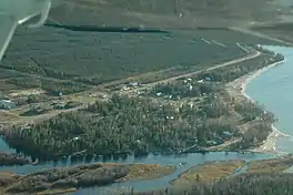
Sambaa K'e
Sambaa K'e[6] (Slavey language: "place of trout"; formerly Trout Lake) is a "Designated Authority"[7] in the Dehcho Region of the Northwest Territories, Canada. The community is located near the Alberta border, east of Fort Liard, on the shore of the lake also known as Sambaa K'e. It has no all-weather road, but can be reached by winter road early in the year or by air (Sambaa K'e Aerodrome) year-round.
Sambaa K'e | |
|---|---|
First Nation (Designated Authority) (Sambaa K'e Dene Band) | |
 | |
 Sambaa K'e  Sambaa K'e | |
| Coordinates: 60°26′33″N 121°14′43″W | |
| Country | Canada |
| Territory | Northwest Territories |
| Region | Dehcho Region |
| Constituency | Nahendeh |
| Census division | Region 4 |
| Trading post | 1796 |
| Settlement | Late 1960s |
| Government | |
| • Chief | Dolphus Jumbo |
| • Band Manager | Ruby Jumbo |
| • MLA | Kevin Menicoche |
| Area | |
| • Land | 119.51 km2 (46.14 sq mi) |
| Elevation | 495 m (1,624 ft) |
| Population (2016)[1] | |
| • Total | 88 |
| • Density | 0.7/km2 (2/sq mi) |
| Time zone | UTC−07:00 (MST) |
| • Summer (DST) | UTC−06:00 (MDT) |
| Canadian Postal code | X0E 1Z0 |
| Area code | 867 |
| Telephone exchange | 206 |
| - Living cost | 162.5A |
| - Food price index | 144.1B |
| Sources: Department of Municipal and Community Affairs,[2] Prince of Wales Northern Heritage Centre,[3] Canada Flight Supplement[4] ^A 2013 figure based on Edmonton = 100[5] ^B 2015 figure based on Yellowknife = 100[5] | |
On June 21, 2016, the settlement officially changed its name from "Trout Lake" to "Sambaa K'e", its name in the Slavey language, meaning "place of trout".[6]
Demographics
|
| ||||||||||||||||||||||||||||||||||||||||||||||||||||||||||||||||||||||||
| Sources: NWT Bureau of Statistics (2001 - 2017)[16] | |||||||||||||||||||||||||||||||||||||||||||||||||||||||||||||||||||||||||
In the 2021 Census of Population conducted by Statistics Canada, Sambaa K’e had a population of 97 living in 49 of its 49 total private dwellings, a change of 10.2% from its 2016 population of 88. With a land area of 118.01 km2 (45.56 sq mi), it had a population density of 0.8/km2 (2.1/sq mi) in 2021.[15]
The majority of its 2016 population (80 people) are First Nations and 45 report South Slavey as a first language.[1]
First Nations
The Dene of the community are represented by the Sambaa K'e First Nation and belong to the Dehcho First Nations.[17]
Services
The community has a small general store and a health centre and no RCMP.[18] Canada Post mail arrives weekly by charter plane. Residents can order books, movies and CDs through the Borrow by Mail program offered by the NWT Public Library Services.[19] There is a small airport, Sambaa K'e Aerodrome, and in the summer Trout Lake Water Aerodrome is in operation.[4]
The community runs the Sambaa K'e Fishing Lodge, an authentic northern fishing experience, in the summer months.
References
- "Population and dwelling counts, for Canada, provinces and territories, and census subdivisions (municipalities), 2016 and 2011 censuses – 100% data (Northwest Territories)". Statistics Canada. February 8, 2017. Retrieved February 1, 2022.
- "NWT Communities - Sambaa-k'e". Government of the Northwest Territories: Department of Municipal and Community Affairs. Retrieved October 29, 2017.
- "Northwest Territories Official Community Names and Pronunciation Guide". Prince of Wales Northern Heritage Centre. Yellowknife: Education, Culture and Employment, Government of the Northwest Territories. Archived from the original on January 13, 2016. Retrieved January 13, 2016.
- Canada Flight Supplement. Effective 0901Z 16 July 2020 to 0901Z 10 September 2020.
- Trout Lake - Statistical Profile at the GNWT
- Trout Lake, N.W.T., changes its name to Sambaa K'e
- Differences in Community Government Structure
- "1981 Census of Canada: Census subdivisions in decreasing population order" (PDF). Statistics Canada. May 1992. Retrieved February 1, 2021.
- "1986 Census: Population - Census Divisions and Census Subdivisions" (PDF). Statistics Canada. September 1987. Retrieved February 1, 2022.
- "91 Census: Census Divisions and Census Subdivisions - Population and Dwelling Counts" (PDF). Statistics Canada. April 1992. Retrieved February 1, 2022.
- "96 Census: A National Overview - Population and Dwelling Counts" (PDF). Statistics Canada. April 1997. Retrieved February 1, 2022.
- "Population and Dwelling Counts, for Canada, Provinces and Territories, and Census Subdivisions (Municipalities), 2001 and 1996 Censuses - 100% Data (Northwest Territories)". Statistics Canada. August 15, 2012. Retrieved February 1, 2022.
- "Population and dwelling counts, for Canada, provinces and territories, and census subdivisions (municipalities), 2006 and 2001 censuses - 100% data (Northwest Territories)". Statistics Canada. August 20, 2021. Retrieved February 1, 2022.
- "Population and dwelling counts, for Canada, provinces and territories, and census subdivisions (municipalities), 2011 and 2006 censuses (Northwest Territories)". Statistics Canada. July 25, 2021. Retrieved February 1, 2022.
- "Population and dwelling counts: Canada, provinces and territories, and census subdivisions (municipalities), Northwest Territories". Statistics Canada. February 9, 2022. Retrieved February 18, 2022.
- Population Estimates By Community from the GNWT
- Sambaa K’e Dene Band at the Dehcho First Nations
- Trout Lake Infrastructure Profile
- Borrow-By-Mail