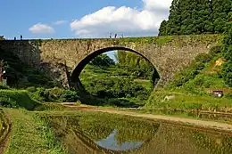
Tsūjun Bridge
Tsūjun Bridge (通潤橋 -kyō) is an aqueduct in Yamato, Kumamoto, Japan. It is an arch bridge completed in 1854 and is 84.0m long. The arch spans 27.3m. It is the largest stone aqueduct in Japan.[1]


The Japanese Agency for Cultural Affairs has designated the bridge an National Treasure.[1][2]
History and technology
This bridge exemplifies the high level of stone bridge technology in existence at the time of its construction. Yasunosuke Futa (1801–1873), who was the head of the then Yabe village, planned it and, after obtaining funding, succeeded in building the bridge in 1854 with the help of the group of 41 stone technicians and many farmers. Its purpose was to let water flow into a higher area (Shiroito Plateau) for farming. After placing wooden frames, stones were placed on the frames and three stone aqueducts were made. After that, the wooden frames were removed. Because the aqueducts were lower than the upper part of the waterway by 6 metres (20 ft), water a reversed siphon mechanism works when water flows through the aqueducts. The stone aqueducts were made watertight with mortar. The bridge was completed in 1854.
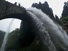
Because the aqueduct is lower than the upstream and downstream waterways, sand and mud may accumulate in the aqueduct. To clean the accumulated dirt, the bridge is able to occasionally release water (and dirt) into the river below. This is mostly done in the farmers' off-season.[3]
References
- 通潤橋(熊本県). 文化財の紹介 (in Japanese). Agency for Cultural Affairs. Archived from the original on 10 September 2012. Retrieved 17 September 2011.
- https://www.bunka.go.jp/koho_hodo_oshirase/hodohappyo/pdf/93900401_01.pdf
- Handbook of international bridge engineering. Chen, Wai-Fah, 1936-, Duan, Lian. Boca Raton. 11 October 2013. p. 1058. ISBN 9781439810309. OCLC 859154927.
{{cite book}}: CS1 maint: location missing publisher (link) CS1 maint: others (link)