Tsing Chuen Wai
Tsing Chuen Wai (Chinese: 青磚圍; lit. 'green bricks walled village') is a walled village located in the Lam Tei area, in the northern part of Tuen Mun District, in Hong Kong.[1]
Tsing Chuen Wai
青磚圍 | |
|---|---|
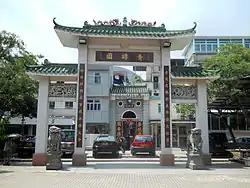 Paifang of Tsing Chuen Wai | |
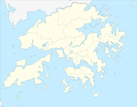 Tsing Chuen Wai Location in Hong Kong | |
| Coordinates: 22.422688°N 113.982343°E | |
| Country | China |
| SAR | |
| District | Tuen Mun District |
| Time zone | UTC+8 (Hong Kong Time) |
.jpg.webp)

Administration
Tsing Chuen Wai is a recognized village under the New Territories Small House Policy.[2] It is one of the 36 villages represented within the Tuen Mun Rural Committee. For electoral purposes, Tsing Chuen Wai is part of the Tuen Mun Rural constituency, which is currently represented by Kenneth Cheung Kam-hung.[3][4]
History
Several villages of the Lam Tei area were established by the To (陶) Clan. Originally from Poyang, Jiangxi[5] (other sources mention Watlam in Guangxi),[6] the To Clan moved to Ngau Tam Mei and then to Tuen Mun Tai Tsuen. Following the increase of the clan population, the village dispersed and developed into five villages in the Lam Tei area: Nai Wai, Tsing Chuen Wai, Tuen Tsz Wai, Lam Tei Tsuen and Tuen Mun San Tsuen, which were all fortified.[6]
Tsing Chuen Wai, formerly known as Mak Yuen Wai (麥園圍; 'Walled Village of Barley Farm'), was established by the To (陶) Clan about 300 years ago. Its present name came from the fact that the village was surrounded by its protective walls made of green bricks. The Tos had conflicts with the Tang Clan of Ping Shan during the Qing Dynasty, and attacks were carried out against the walled village. Watchmen at the watchtowers were killed but Tsing Chuen Wai was never captured by the Tangs. The enclosing walls and watchtowers were torn down in the 1960s.[7]
Tsing Chuen Wai appears on the "Map of the San-On District", published in 1866 by Simeone Volonteri.[8]
Features
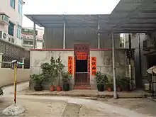
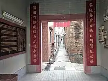
The only surviving portion of the original green-brick boundary wall at the main entrance of the Wai gives visitors an insight into the walled village's historical outlook.[1] Tin Hau, Kwan Tai and a Qing official are worshipped in the village shrine.[7]
Transportation
Take LRT route No. 610, 614 or 615 and alight at Lam Tei stop, or KMB route No. 53, 63X, 68A, or minibus running between Jordan and Yuen Long.
See also
- Walled villages of Hong Kong
- Tuen Tsz Wai, another walled village established by the To Clan, located next to Tsing Chuen Wai
References
- Welcome to 18 Districts - Tuen Mun District
- "List of Recognized Villages under the New Territories Small House Policy" (PDF). Lands Department. September 2009.
- "Recommended District Council Constituency Areas (Tuen Mun District)" (PDF). Electoral Affairs Commission. Retrieved 12 August 2021.
- "Tuen Mun District Council - Tuen Mun DC Members". District Council. Retrieved 12 August 2021.
- Antiquities and Monuments Office. Hong Kong Traditional Chinese Architectural Information System. Tuen Tsz Wai - History
- Antiquities Advisory Board. Historic Building Appraisal. To Ancestral Hall, Tuen Tze Wai
- Antiquities and Monuments Office. Historic Building Appraisal. Watchtower, Tsing Chuen Wai, Tuen Mun
- Hill, Ronald D. (1985). "Fragments and speculations: the walled villages of Hong Kong". Journal of the Hong Kong Archaeological Society. Hong Kong Archaeological Society. 11: 25-38. OCLC 02465191.
External links
- Delineation of area of existing village Tsing Chuen Wai (Tuen Mun) for election of resident representative (2019 to 2022)
- Antiquities and Monuments Office. Hong Kong Traditional Chinese Architectural Information System. Tsing Chuen Wai
- Film Services Office: Tsing Chuen Wai
- Webpage about Tsing Chuen Wai
- Antiquities Advisory Board. Pictures of the remains of the Watchtower at Tsing Chuen Wai