Tsogtsalu
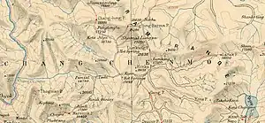
Tsogtsalu[lower-alpha 1] or Tsolu[1] is a pasture and campsite in the Ladakh union territory of India, in the Chang Chenmo Valley close India's border with China. It is located at the confluence of the Rimdi Chu river that flows down from Marsemik La and the Chang Chenmo River. During the British Raj, this was a halting spot for travellers to Central Asia via the 'Chang Chenmo route', passing through Aksai Chin. After Indian independence, a border outpost was established here by a border police party headed by Captain Karam Singh. It continues to serve as a base for India's border forces.
Tsogstalu | |
|---|---|
Pasture and border outpost | |
 Tsogstalu | |
| Coordinates: 34°16′04″N 78°44′32″E | |
| Country | |
| Union territory | Ladakh |
| District | Leh |
| Elevation | 4,500 m (14,760 ft) |
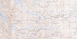
Within India, it is reachable by two motorable roads, the "Phobrang-Marsimik La-Tsogtsalu-Hot Springs Road" (PMTHR) or "Marsimik La Road" via Phobrang-Marsimik La-Tsogstsalu to Hot Springs,[4] [5][6] and via the other alternate route the 55 km long "Changchenmo-Tsogtsalu Road" (CTR) from confluence of Changchenmo & Shyok River to Tsogtsalu.[7]
References
- Gazetteer of Kashmir and Ladak (1890), p. 832.
- Mullik, The Chinese Betrayal (1971), p. 201.
- Johri, Chinese Invasion of Ladakh (1969), p. 119.
- India boosts road links to LAC standoff points, Indian Express, 2nd July 2023.
- Forbidden zones in Ladakh to soon welcome tourists, Times of India, 26 May 2023.
- "Amid Doklam standoff, MHA asks BRO to build stand-alone road for access to vantage points". The Indian Express. 23 August 2017.
- [https://m.economictimes.com/epaper/delhicapital/2023/aug/03/et-poli/over-20-strategic-roads-close-to-lac-have-year-end-deadline/articleshow/102366166.cms Over 20 strategic roads close to LAC have the ear and deadline], The Economic Times, 3 Aug 2023.
Bibliography
- Gazetteer of Kashmir and Ladak, Calcutta: Superintendent of Government Printing, 1890
- India, Ministry of External Affairs, ed. (1962), Report of the Officials of the Governments of India and the People's Republic of China on the Boundary Question, Government of India Press
- Johri, Sitaram (1969), Chinese Invasion of Ladakh, Himalaya Publications
- Hoffmann, Steven A. (1990), India and the China Crisis, University of California Press, ISBN 978-0-520-06537-6
- Maxwell, Neville (1970), India's China War, Pantheon Books, ISBN 978-0-394-47051-1 – via archive.org
- Mullik, B. N. (1971), My Years with Nehru: The Chinese Betrayal, Allied Publishers – via archive.org
- Sandhu, P. J. S.; Shankar, Vinay; Dwivedi, G. G. (2015), 1962: A View from the Other Side of the Hill, Vij Books India Pvt Ltd, ISBN 978-93-84464-37-0