Khuga River
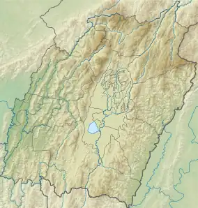
Khuga River,[lower-alpha 1] also known as the Tuitha River, is a river in Manipur, India. It originates in the Churachandpur district and flows through the district for much of its course, entering the Imphal Valley near Torbung. Then it flows east and joins the Manipur River near Ithai.
| Khuga River Tuitha River | |
|---|---|
  | |
| Location | |
| Country | India |
| State | Manipur |
| Districts | Churachandpur, Bishnupur |
| Physical characteristics | |
| Source | |
| • coordinates | 24.0821°N 93.6479°E |
| Mouth | |
• coordinates | 24.4285°N 93.8378°E |
| Basin features | |
| Progression | Manipur River |
| River system | Chindwin |
| Waterbodies | Khuga Reservoir |
Course
The Khuga River originates in the southern part of the Churachandpur district, close to the border with Chin State (Myanmar), and flows north into the Imphal Valley south of Moirang. The upper course of the river is traditionally called "Tuitha" in Kuki-Chin languages.[3] But the name is also applied to a south-flowing head stream of the river originating near Mount Mulam.[4] British maps have noted this headstream as "Hilpi River". Another headstream flowing north from the southern borders joins this stream near Hiangtam Khul (24.0821°N 93.6479°E), forming the Khuga River.[4]
The combined river flows due north, breaking into a wide plain near the Mata village, which is referred to as the "Lamka plain" (Lamka zaang).[5] Near Mata, a multi-purpose dam called Mata Dam (or Khuga Dam) has been constructed in 2010. It forms a long reservoir, submerging much of the upper valley.[6] After the dam, the Khuga river flows for about 16 km through the Lamka plain/Khuga valley before entering the Imphal Valley near Torbung (in the Bishnupur district).
Near Torbung, streams from the western Thangjing hills, prominently the Torbung stream, join the Khuga River, as does the outlet stream of the Loktak Lake. The combined river flows east and joins the Imphal River near Ithai to form the Manipur River.[4]
Valley
Khuga River flows through a wide valley, which appears as if it is an extension of the Imphal Valley. The second largest town of Manipur, Churachandpur, locally known as Lamka, lies in the valley.[7] Numerous other villages also dot the valley, housing a large portion of the Churachandpur district's population. The region has been referred to as the "Lamka plain".[5]
The Tedim Road, running between the Imphal City and the town of Tedim in the Chin State of Myanmar, partly runs through the Lamka plain / Khuga river valley. It leaves the valley near the village of S. Geltui, and follows a hill route to reach Singngat, after which, it enters the Tuivai River valley up to the town of Behiang on the southern border.
History
The Khuga River was relatively unknown to the history of Manipur. Its first mention is found in Cheitharol Kumbaba (Manipuri court chronicles) in the year 1712, noting a murder at "Torbung, near Khuka".[8] After the British began to exert their influence in Manipur, they regarded the southwestern part of the present-day Manipur state as part of "Lushai hills". The extent of the Manipur kingdom was till the southern periphery of the Imphal Valley, referred to as the "Moirang frontier" in an administrative report in 1876.[9] The Gazetteer of Manipur, published in 1886, makes no mention of the Khuga River and uses the name "Turbung stream" for its lower course running in the Imphal Valley.[10]
Scholar Pum Khan Pau believes that the Khuga River valley might have been traversed by Manipuris for the first time in 1857, when Maharaja Chandrakirti led an expedition to Tedim (in the present day Chin State of Myanmar), then the central base of the Kamhau-Sukte tribes. The Manipuri troops fled "in confusion" after facing the combined troops of Kamhau, Sukte and Sihzang tribes, and returned to the Imphal Valley via a previously "unknown route", which eventually formed the route of the present day Tedim Road.[11]
In 1872, the Maharaja sent another expedition to the Chivu salt springs (near modern Behiang), ostensibly to support the British Lushai Expedition. The Manipuri troops camped there for two months, and arrested the Kamhau chief of Mualpi during their return journey. Even though the British officials decried the expedition as "treachery", the Maharaja succeeded in marking his claimed territory.[12] In 1894, when the British delineated the border between Manipur and the "Chin Hills" of Burma, they rant it close to the Chivu springs.[13]
During the Kuki Rebellion of 1917–1919, the British constructed a road to Hiangtam, south of Singngat along this route. Hiangtam was described as a stronghold of the Kuki rebels, and the British needed a way to reach it. The junction point of the Hiangtam road and the Tipaimukh road came to be known as Hiangtam Lamka, which formed the core of the modern Lamka or Churachandpur town.[14]
During the World War II, the British improved the Hiangtam road and extended it to Tedim for the defence of eastern frontier of India. The resulting road came to be known as the Tedim Road, running between the Imphal City and the town of Tedim. Seven decisive battles were fought along this road between the 17 Indian Division of the British and the 33 Division of Japan. The Japanese reached Churachandpur on 8 April 1944, and four battles were fought within Manipur, including one at Torbung. Eventually the Japanese were defeated at Imphal and withdrew along the same road with heavy losses.[15]
References
- Parratt, The Court Chronicle of the Kings of Manipur, Vol. 1 (2005), p. 122
- "Annual Administration Report of the Munnipoor Agency, For the year ending 30th June 1874–75", Selections from the Records of the Government of India, Foreign Department, Calcutta: Foreign Department Press, 1874, p. 7 – via archive.org
- Churachandpur District Census Handbook (2011), p. 24.
- Churachandpur District Census Handbook (2011), p. 25.
- Pau, Indo-Burma Frontier and the Making of the Chin Hills (2019), p. xii: "From a remote hill village in the Indo-Burma border, my grandparents moved to the plain of Lamka (Lamka zaang) in Churachandpur District of Manipur chiefly in search of better livelihood and opportunity for the education of their children."
- Khuga Dam, Churachandpur District administration, retrieved 1 September 2023.
- Sukrit Baruah (10 July 2023), "Amid ongoing violence, why there is an open challenge to the name of Manipur's Churachandpur", The Indian Express
- Parratt, The Court Chronicle of the Kings of Manipur, Vol. 1 (2005), p. 122. The expression "near Khuka" suggests that the reference could have been to a place rather than a river.
- Annual Administration Report of the Munnipoor Agency for the year 1875–1876, Calcutta: Foreign Department Press, 1876, p. 5 – via archive.org
- Dun, E. W. (1992) [1886], Gazetteer of Manipur, Manas Publications, p. 193 – via archive.org (Villages such as Saikot and Saitul are described as being "on the Turbung stream".)
- Pau, Tedim Road (2012), pp. 778–779.
- Pau, Indo-Burma Frontier and the Making of the Chin Hills (2019), pp. 67–69, 160.
- Pau, Indo-Burma Frontier and the Making of the Chin Hills (2019), p. 161.
- Sukrit Baruah (10 July 2023), "Amid ongoing violence, why there is an open challenge to the name of Manipur's Churachandpur", The Indian Express
- Pau, Tedim Road (2012).
Bibliography
- Churachandpur District Census Handbook (PDF), Directorate of Census Operations, Manipur, 2011
- Parratt, Saroj Nalini Arambam (2005). The Court Chronicle of the Kings of Manipur: The Cheitharon Kumpapa, Volume 1. London: Routledge. ISBN 0-415-34430-1.
- Pau, Pum Khan (2012), "Tedim Road—The Strategic Road on a Frontier: A Historical Analysis", Strategic Analysis, 36 (5): 776–786, doi:10.1080/09700161.2012.712387
- Pau, Pum Khan (2019), Indo-Burma Frontier and the Making of the Chin Hills: Empire and Resistance, Taylor & Francis, ISBN 9781000507454
External links
- Khuga River, OpenStreetMap, retrieved 2 September 2023.
- Tedim Road, OpenStreetMap, retrieved 2 September 2023.