Turóc County
Turóc (Hungarian, historically also spelled Túrócz), Slovak: Turiec, Latin: Thurotzium/comitatus Thurociensis, German: Turz) was an administrative county (comitatus) of the Kingdom of Hungary. Its territory is now in north-western Slovakia, where the corresponding Slovak name Turiec is only an informal designation of the corresponding territory.
| Turóc County | |
|---|---|
| County of the Kingdom of Hungary | |
| 14th century–1920 | |
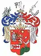 Coat of arms
| |
 | |
| Capital | Turócszentmárton |
| Area | |
| • Coordinates | 49°4′N 18°55′E |
• 1910 | 1,123 km2 (434 sq mi) |
| Population | |
• 1910 | 55703 |
| History | |
| History | |
• Established | 14th century |
• Treaty of Trianon | June 4 1920 |
| Today part of | Slovakia |
| Martin is the current name of the capital | |
Geography
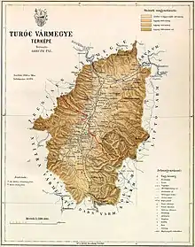
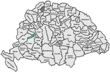
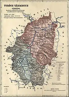
Turóc county shared borders with the counties of Nyitra, Trencsén, Árva, Liptó, Zólyom and Bars, situated between the Lesser Fatra (Kis-Fátra) and Greater Fatra (Nagy-Fátra) Mountains. The river Turóc flowed through the county. Its area was 1123 km² around 1910.
Capitals
The capitals of the Turóc county were the Szklabinya Castle and Turócszentmárton (present-day Martin; Slovak name until 1950: Turčiansky Svätý Martin); from 1772 only Turócszentmárton was the capital.
History
Turóc county as a Hungarian comitatus arose in the 14th century. In the aftermath of World War I, the area of the now defunct Turóc county became part of newly formed Czechoslovakia, as recognized by the concerned states in 1920 by the Treaty of Trianon. The territory of the county is now part of Slovakia.
Demographics
| Census | Total | Slovak | German | Hungarian | Other or unknown |
|---|---|---|---|---|---|
| 1880[1] | 45,933 | 33,951 (76.58%) | 8,988 (20.27%) | 1,066 (2.40%) | 330 (0.74%) |
| 1890[2] | 49,979 | 37,954 (75.94%) | 10,180 (20.37%) | 1,358 (2.72%) | 487 (0.97%) |
| 1900[3] | 51,956 | 38,233 (73.59%) | 11,039 (21.25%) | 2,185 (4.21%) | 499 (0.96%) |
| 1910[4] | 55,703 | 38,432 (68.99%) | 10,993 (19.74%) | 5,560 (9.98%) | 718 (1.29%) |
| Census | Total | Lutheran | Roman Catholic | Jewish | Other or unknown |
|---|---|---|---|---|---|
| 1880 | 45,933 | 25,279 (55.03%) | 18,413 (40.09%) | 2,188 (4.76%) | 53 (0.12%) |
| 1890 | 49,979 | 26,834 (53.69%) | 20,853 (41.72%) | 2,214 (4.43%) | 78 (0.16%) |
| 1900 | 51,956 | 27,075 (52.11%) | 22,677 (43.65%) | 2,022 (3.89%) | 182 (0.35%) |
| 1910 | 55,703 | 27,651 (49.64%) | 25,607 (45.97%) | 1,981 (3.56%) | 464 (0.83%) |
Subdivisions
In the early 20th century, the subdivisions of Turóc county were:
- Lower Turóc – its center was Turócszentmárton and the subregion roughly corresponds to the present-day District of Martin
- Upper Turóc – its center was Stubnyafürdő and the subregion roughly corresponds to the present-day District of Turčianske Teplice
| Districts (járás) | |
|---|---|
| District | Capital |
| Stubnyafürdő | Stubnyafürdő (now Turčianske Teplice) |
| Turócszentmárton | Turócszentmárton (now Martin) |
Governors
Notes
- Only linguistic communities > 1% are displayed.
- Only religious communities > 1% are displayed.
References
- "Az 1881. év elején végrehajtott népszámlálás főbb eredményei megyék és községek szerint rendezve, II. kötet (1882)". library.hungaricana.hu. Retrieved September 28, 2021.
- "A Magyar Korona országainak helységnévtára (1892)". library.hungaricana.hu. Retrieved September 29, 2021.
- "A MAGYAR KORONA ORSZÁGAINAK 1900". library.hungaricana.hu. Retrieved September 29, 2021.
- "KlimoTheca :: Könyvtár". Kt.lib.pte.hu. Retrieved September 29, 2021.
- Scriptores Rerum Hungaricarum minores hactenus inediti, synchroni, aut proxime coaevi: 2. Typ. regiae Univers. 1798. pp. 226–.
- Okolicsanyi, Paulus (1710). Historia diplomatica de statu religionis evangelicae in Hungaria. p. 23.
- Pál Wallaszky (1785). Conspectus reipublicae litterariae in Hungaria ab initiis regni ad nostra usque ad tempora delineatus a Paullo Wallaszky. apud Antonium Loewe, typgraphum et bibliopolam. pp. 258–.
- Specimen Prævium Diplomaticum Historico-Criticum De Electione Regis Ejusdem: 1. Typis Joannis Thomæ Nobilis De Trattnern. 1767. pp. 260–.
