Turakirae Head
Turakirae Head is a promontory on the southern coast of New Zealand's North Island.[1] It is located at the western end of Palliser Bay, 20 kilometres southeast of Wellington, at the southern end of the Remutaka Range. The head is an excellent example of tectonic uplift within the Wellington region. There are a series of raised terraces which show where the shoreline existed prior to large seismic events. The Turakirae Head is also home to a seal colony and southern bull kelp.[2]
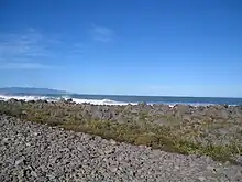
Raised beach Turakirae Head
Turakirae Head
Turakirae also marks the southernmost coastal boundary point for the Ngāti Kahungunu tribe which extends as north as Paritu which is just north south of Gisborne.
References
- "Place name detail: Turakirae Head". New Zealand Gazetteer. New Zealand Geographic Board. Retrieved 25 March 2010.
- Vaux, Felix; Parvizi, Elahe; Craw, Dave; Fraser, Ceridwen I.; Waters, Jonathan M. (2022). "Parallel recolonisations generate distinct genomic sectors in kelp following high magnitude earthquake disturbance?". Molecular Ecology. 31 (18): 4818–4831. doi:10.1111/mec.16535. PMC 9540901. PMID 35582778.
This article is issued from Wikipedia. The text is licensed under Creative Commons - Attribution - Sharealike. Additional terms may apply for the media files.