Tympaki
Tympaki (Greek: Τυμπάκι) is a town and a former municipality in the Heraklion regional unit, Crete, Greece. Since the 2011 local government reforms it is part of the municipality of Faistos, of which it is a municipal unit,[2] the unit has an area of 157.122 km2 (60.665 sq mi).[3]
Tympaki
Τυμπάκι | |
|---|---|
 Tympaki Location within the regional unit 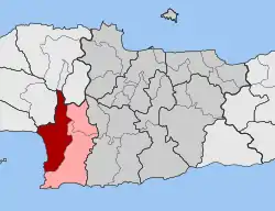 | |
| Coordinates: 35°04′N 24°46′E | |
| Country | Greece |
| Administrative region | Crete |
| Regional unit | Heraklion |
| Municipality | Faistos |
| • Municipal unit | 157.1 km2 (60.7 sq mi) |
| Elevation | 29 m (95 ft) |
| Population (2011)[1] | |
| • Municipal unit | 10,079 |
| • Municipal unit density | 64/km2 (170/sq mi) |
| Community | |
| • Population | 5,746 (2011) |
| Time zone | UTC+2 (EET) |
| • Summer (DST) | UTC+3 (EEST) |
The town is located on the south coast, between Agia Galini and Matala, and has a population of about 5,700 people (10,000 for the municipal unit). In 2005, a major container harbour and free-trade zone had been rumored to be built in the area. As of January 2009, it appears the project has been canceled, in part due to the strong opposition from the local population.[4]
Geography & Climate
Tympaki is located in the southern coast of the island of Crete, in the regional unit of Heraklion. Tympaki features a hot-summer Mediterranean climate (Köppen: Csa) with hot, dry summers and mild, rainy winters.
| Climate data for Tympaki Airport (1959-2010) 6 m asl | |||||||||||||
|---|---|---|---|---|---|---|---|---|---|---|---|---|---|
| Month | Jan | Feb | Mar | Apr | May | Jun | Jul | Aug | Sep | Oct | Nov | Dec | Year |
| Average high °C (°F) | 15.9 (60.6) |
15.9 (60.6) |
17.7 (63.9) |
20.7 (69.3) |
24.6 (76.3) |
28.9 (84.0) |
31.9 (89.4) |
31.9 (89.4) |
28.8 (83.8) |
25.0 (77.0) |
21.2 (70.2) |
17.6 (63.7) |
23.3 (74.0) |
| Daily mean °C (°F) | 11.7 (53.1) |
11.8 (53.2) |
13.5 (56.3) |
16.5 (61.7) |
20.7 (69.3) |
25.1 (77.2) |
27.9 (82.2) |
27.7 (81.9) |
24.4 (75.9) |
20.4 (68.7) |
16.4 (61.5) |
13.3 (55.9) |
19.1 (66.4) |
| Average low °C (°F) | 7.5 (45.5) |
7.4 (45.3) |
8.4 (47.1) |
10.6 (51.1) |
14.1 (57.4) |
17.8 (64.0) |
20.6 (69.1) |
20.7 (69.3) |
18.2 (64.8) |
15.1 (59.2) |
11.9 (53.4) |
9.2 (48.6) |
13.5 (56.2) |
| Average rainfall mm (inches) | 93.7 (3.69) |
67.3 (2.65) |
43.6 (1.72) |
20.1 (0.79) |
9.3 (0.37) |
1.1 (0.04) |
0.1 (0.00) |
0.5 (0.02) |
12.0 (0.47) |
45.6 (1.80) |
74.2 (2.92) |
107.1 (4.22) |
474.6 (18.69) |
| Average rainy days (≥ 0.01 mm) | 11.1 | 9.6 | 6.8 | 3.8 | 2.0 | 0.5 | 0.0 | 0.1 | 1.2 | 4.6 | 6.9 | 11.9 | 58.5 |
| Source: HNMS[5] | |||||||||||||
References
- "Απογραφή Πληθυσμού - Κατοικιών 2011. ΜΟΝΙΜΟΣ Πληθυσμός" (in Greek). Hellenic Statistical Authority.
- "ΦΕΚ B 1292/2010, Kallikratis reform municipalities" (in Greek). Government Gazette.
- "Population & housing census 2001 (incl. area and average elevation)" (PDF) (in Greek). National Statistical Service of Greece. Archived from the original (PDF) on 2015-09-21. Retrieved 2016-12-13.
- "Archived copy". Archived from the original on 2007-01-23. Retrieved 2007-01-15.
{{cite web}}: CS1 maint: archived copy as title (link) - http://www.emy.gr/emy/el/climatology/climatology_city?perifereia=Crete&poli=Tympaki