1975 Pacific typhoon season
The 1975 Pacific typhoon season was one of the deadliest tropical cyclone seasons on record, with nearly 229,000 fatalities occurring during the season. It had no official bounds; it ran year-round in 1975, but most tropical cyclones tend to form in the northwestern Pacific Ocean between June and December. These dates conventionally delimit the period of each year when most tropical cyclones form in the northwestern Pacific Ocean.
| 1975 Pacific typhoon season | |
|---|---|
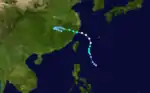
 Season summary map | |
| Seasonal boundaries | |
| First system formed | January 20, 1975 |
| Last system dissipated | December 30, 1975 |
| Strongest storm | |
| Name | June |
| • Maximum winds | 295 km/h (185 mph) (1-minute sustained) |
| • Lowest pressure | 875 hPa (mbar) |
| Seasonal statistics | |
| Total depressions | 39 |
| Total storms | 21 |
| Typhoons | 14 |
| Super typhoons | 3 (unofficial) |
| Total fatalities | >229,166 (Deadliest Pacific typhoon season on record) |
| Total damage | > $1.35 billion (1975 USD) |
| Related articles | |
Tropical Storms formed in the entire west pacific basin were assigned a name by the Joint Typhoon Warning Center. Tropical depressions in this basin have the "W" suffix added to their number. Tropical depressions that enter or form in the Philippine area of responsibility are assigned a name by the Philippine Atmospheric, Geophysical and Astronomical Services Administration or PAGASA. This can often result in the same storm having two names.
Some of the notable storms here are Typhoon Nina, which caused the Banqiao Dam flood, which resulted in approximately 126,000 people dead, and Typhoon June, which was the strongest storm on record with a pressure of 875 mbar, until beaten by Typhoon Tip in 1979 with 870 mbar.
Systems
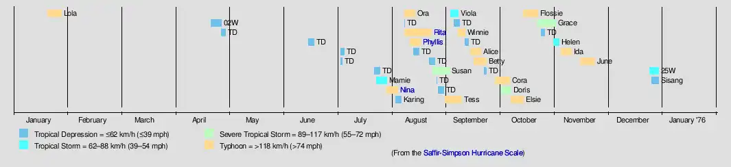
25 tropical depressions formed this year in the Western Pacific, of which 20 became tropical storms. 14 storms reached typhoon intensity, of which 3 reached super typhoon strength.[1]
Typhoon Lola (Auring)
| Typhoon (JMA) | |
| Category 1-equivalent typhoon (SSHWS) | |
 | |
| Duration | January 20 – January 28 |
|---|---|
| Peak intensity | 130 km/h (80 mph) (1-min); 975 hPa (mbar) |
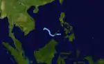
Typhoon Lola (Auring) was a very early typhoon. It made landfall on Mindanao as a minimal typhoon on January 24 and transversed the southern Philippines as a tropical storm. Lola crossed the South China Sea before stalling in the open sea and dissipating on January 28. The typhoon caused 30 casualties from mudslides and heavy rain.
Tropical Depression 02W
| Tropical depression (JMA) | |
| Tropical depression (SSHWS) | |
 | |
| Duration | April 22 – April 28 |
|---|---|
| Peak intensity | 45 km/h (30 mph) (1-min); 1004 hPa (mbar) |
Tropical Depression 02W formed over the Philippines and crossed them before dissipating over the South China Sea.
Tropical Storm Mamie
| Tropical storm (JMA) | |
| Tropical storm (SSHWS) | |
 | |
| Duration | July 24 – July 30 |
|---|---|
| Peak intensity | 75 km/h (45 mph) (1-min); 992 hPa (mbar) |
Tropical Storm Mamie formed north of Guam, and briefly attained tropical storm status before weakening. It then passed south of Japan as a tropical depression before dissipating just south of Korea.
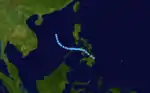
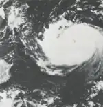
Typhoon Nina (Bebeng)
| Typhoon (JMA) | |
| Category 4-equivalent typhoon (SSHWS) | |
_Ex._Deepening.JPG.webp) 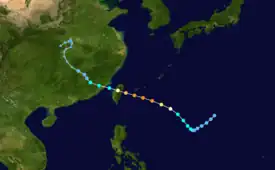 | |
| Duration | July 30 – August 5 |
|---|---|
| Peak intensity | 250 km/h (155 mph) (1-min); 900 hPa (mbar) |
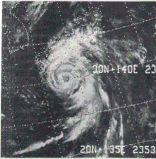
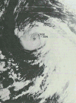
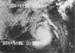
Nina was a short-lived but rapidly intensifying typhoon. After forming on July 30, it struck Taiwan at super typhoon intensity. It stayed a typhoon during its passage over the island, causing 25 fatalities and widespread damage. It emerged into the Formosa Strait and weakened to a tropical storm. Nina headed inland. Its moisture interacted with a cold front, causing a huge amount of rainfall. The rainfall contributed to the bursting of the Banqiao Dam, causing the deaths of at least 229,000 people.
Tropical Depression 05W (Karing)
| Tropical depression (JMA) | |
| Tropical depression (SSHWS) | |
 | |
| Duration | August 4 – August 7 |
|---|---|
| Peak intensity | 55 km/h (35 mph) (10-min); 998 hPa (mbar) |
Tropical Depression 05W (Karing) formed east-northeast of the Philippines and traveled north then northwest before dissipating off the coast of China.
Typhoon Ora (Diding)
| Typhoon (JMA) | |
| Category 1-equivalent typhoon (SSHWS) | |
 | |
| Duration | August 9 – August 15 |
|---|---|
| Peak intensity | 120 km/h (75 mph) (1-min); 970 hPa (mbar) |
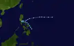
Typhoon Ora first developed as an weak circulation on August 9. The influence of a nearby upper-level trough allowed it to intensify from a depression to a Category 1 typhoon in 30 hours. The typhoon passed Okinawa before making landfall in China near Wenzhou. It dissipated over land a few days later. Choppy seas caused by Ora sank a crowded motorboat near Leyte, killing 15 people.[2]
Typhoon Rita
| Typhoon (JMA) | |
| Category 1-equivalent typhoon (SSHWS) | |
  | |
| Duration | August 9 – August 24 |
|---|---|
| Peak intensity | 150 km/h (90 mph) (1-min); 965 hPa (mbar) |
Rita formed August 17 and erratically headed north and affected the Ryūkyū Islands. Rita then made landfall on Shikoku as a moderately strong Category 1 typhoon. It moved along the entire length of Japan, weakening to a depression. Rita strengthened back into a tropical storm over the Kuril Islands— an unusually northerly location— before dissipating on August 24. At least 26 deaths can be attributed to this typhoon from the heavy flooding— the worst in 10 years.
Typhoon Phyllis
| Typhoon (JMA) | |
| Category 4-equivalent typhoon (SSHWS) | |
  | |
| Duration | August 12 – August 18 |
|---|---|
| Peak intensity | 220 km/h (140 mph) (1-min); 920 hPa (mbar) |
Phyllis struck the southern part of Japan on August 17 as a minimal typhoon, having weakened from a peak of 140 mph winds. Phyllis caused over 60 casualties, with landslides and flooding causing moderate to heavy damage.
Severe Tropical Storm Susan
| Severe tropical storm (JMA) | |
| Tropical storm (SSHWS) | |
 | |
| Duration | August 25 – September 3 |
|---|---|
| Peak intensity | 95 km/h (60 mph) (1-min); 985 hPa (mbar) |
Tropical Storm Susan formed far southwest of Tokyo, and slowly traveled northwards, reaching tropical storm intensity before weakening and finally dissipating on 3 September at sea west of Hokkaido.
Typhoon Tess
| Typhoon (JMA) | |
| Category 2-equivalent typhoon (SSHWS) | |
  | |
| Duration | September 1 – September 10 |
|---|---|
| Peak intensity | 175 km/h (110 mph) (1-min); 945 hPa (mbar) |
Typhoon Tess was first noted as a closed circulation on 1 September 600 nautical miles east-northeast of Saipan. The storm intensified over the next few days, becoming a typhoon on the 3rd. The cyclone reached its peak intensity on the 4th. Tess then weakened, losing typhoon status on the 8th, and dissipating over the Sea of Irkutsk on the 10th, being absorbed into a frontal system.[3]
Tropical Storm Viola (Gening)
| Tropical storm (JMA) | |
| Tropical storm (SSHWS) | |
  | |
| Duration | September 4 – September 8 |
|---|---|
| Peak intensity | 85 km/h (50 mph) (1-min); 996 hPa (mbar) |
Tropical Storm Viola formed at sea east of the Philippines and tracked northeast before dissipating four days later.
Typhoon Winnie
| Typhoon (JMA) | |
| Category 1-equivalent typhoon (SSHWS) | |
  | |
| Duration | September 8 – September 12 |
|---|---|
| Peak intensity | 120 km/h (75 mph) (1-min); 980 hPa (mbar) |
Typhoon Winnie was first detected as a disturbance on 5 September, but it did not become a circulation until the 8th. Winnie tracked northwards, becoming a category 1 typhoon, but an unfavorable environment prevented it from intensifying further. It became extratropical on the 12th.[4]
Typhoon Alice (Herming)
| Typhoon (JMA) | |
| Category 1-equivalent typhoon (SSHWS) | |
  | |
| Duration | September 15 – September 21 |
|---|---|
| Peak intensity | 140 km/h (85 mph) (1-min); 970 hPa (mbar) |
Typhoon Alice, (Not to be confused with Typhoon Alice from 1979) hit the Philippine island of Luzon, It weakened over the South China Sea then struck China and Vietnam as a tropical storm, Then it finally dissipated over Thailand.
Typhoon Betty (Ising)
| Typhoon (JMA) | |
| Category 2-equivalent typhoon (SSHWS) | |
  | |
| Duration | September 17 – September 24 |
|---|---|
| Peak intensity | 175 km/h (110 mph) (1-min); 950 hPa (mbar) |
Typhoon Cora (Luding)
| Typhoon (JMA) | |
| Category 3-equivalent typhoon (SSHWS) | |
  | |
| Duration | September 29 – October 7 |
|---|---|
| Peak intensity | 195 km/h (120 mph) (1-min); 945 hPa (mbar) |
Cora re-curved east of Japan.
Severe Tropical Storm Doris
| Severe tropical storm (JMA) | |
| Tropical storm (SSHWS) | |
 | |
| Duration | October 2 – October 8 |
|---|---|
| Peak intensity | 100 km/h (65 mph) (1-min); 985 hPa (mbar) |
Doris hit China as a high-end tropical storm.
Typhoon Elsie (Mameng)
| Typhoon (JMA) | |
| Category 4-equivalent typhoon (SSHWS) | |
  | |
| Duration | October 8 – October 15 |
|---|---|
| Peak intensity | 250 km/h (155 mph) (1-min); 900 hPa (mbar) |
Elsie hit Hong Kong.
Typhoon Flossie (Neneng)
| Typhoon (JMA) | |
| Category 1-equivalent typhoon (SSHWS) | |
 | |
| Duration | October 15 – October 23 |
|---|---|
| Peak intensity | 130 km/h (80 mph) (1-min); 970 hPa (mbar) |
Flossie struck the extreme southern part of China at Category 1 intensity. 44 people were lost from 2 freighters sinking.
Severe Tropical Storm Grace (Oniang)
| Severe tropical storm (JMA) | |
| Tropical storm (SSHWS) | |
 | |
| Duration | October 23 – November 2 |
|---|---|
| Peak intensity | 110 km/h (70 mph) (1-min); 985 hPa (mbar) |
Grace moved northwest away from the Philippines.
Tropical Storm Helen (Pepang)
| Tropical storm (JMA) | |
| Tropical storm (SSHWS) | |
 | |
| Duration | November 1 – November 4 |
|---|---|
| Peak intensity | 85 km/h (50 mph) (1-min); 1000 hPa (mbar) |
Helen hit Vietnam and the Philippines.
Typhoon Ida
| Typhoon (JMA) | |
| Category 2-equivalent typhoon (SSHWS) | |
 | |
| Duration | November 5 – November 11 |
|---|---|
| Peak intensity | 155 km/h (100 mph) (1-min); 950 hPa (mbar) |
Ida recurved out to sea and had no effect on land.
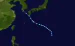
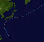
Typhoon June (Rosing)
| Typhoon (JMA) | |
| Category 5-equivalent super typhoon (SSHWS) | |
  | |
| Duration | November 16 – November 24 |
|---|---|
| Peak intensity | 295 km/h (185 mph) (1-min); 875 hPa (mbar) |
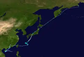
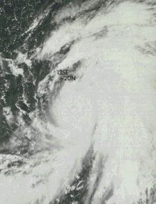
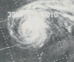
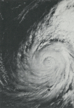
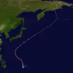
On November 15, a disturbance was first detected in the monsoon trough well to the southeast of Guam, before finally developing into a tropical depression on November 16. Moving erratically, the depression was then later upgraded by the JTWC to a tropical storm. During November 17-18 June then began to explosively deepen as it moved to the north in response to a weakness in the ridge caused by a nearby trough, deepening as much as 52 mbars in under 12 hours, and 90 mbars in 24 hours. Early on November 19, a US Air Force reconnaissance aircraft measured a near record low pressure of 875mb just off the eyewall, indicating it could have been stronger. Shortly after the near-record peak, June then began a eyewall replacement cycle, becoming one of the first recorded cases of triple eyewalls.[5] It then began to slowly weaken as it moved northwest, weakening below category 5 status early on November 21, before beginning to recurve to the northeast as it began extratropical transition, achieving a forward speed as high as 70mph. June finally became extratropical late on November 23. The remnants then became a powerful extratropical storm, with a pressure of 960mb before it was last noted over far northeastern Siberia.[6]
Typhoon June never made landfall, but passed 230 miles west of Guam, causing severe flooding.[7] There were no casualties, but several buildings were destroyed by the strong winds by June, and storm surge and crop damage was estimated at $300,000.[7]
Storm names
International
Western North Pacific tropical cyclones were named by the Joint Typhoon Warning Center. The first storm of 1975 was named Lola and the final one was named June.
|
|
|
|
Philippines
| Auring | Bebeng | Karing | Diding | Etang |
| Gening | Herming | Ising | Luding | Mameng |
| Neneng | Oniang | Pepang | Rosing | Sisang |
| Trining (unused) | Uring (unused) | Warling (unused) | Yayang (unused) | |
| Auxiliary list | ||||
|---|---|---|---|---|
| Ading (unused) | ||||
| Barang (unused) | Krising (unused) | Dadang (unused) | Erling (unused) | Goying (unused) |
The Philippine Atmospheric, Geophysical and Astronomical Services Administration uses its own naming scheme for tropical cyclones in their area of responsibility. PAGASA assigns names to tropical depressions that form within their area of responsibility and any tropical cyclone that might move into their area of responsibility. Should the list of names for a given year prove to be insufficient, names are taken from an auxiliary list, the first 6 of which are published each year before the season starts. Names not retired from this list will be used again in the 1979 season. This is the same list used for the 1971 season. PAGASA uses its own naming scheme that starts in the Filipino alphabet, with names of Filipino female names ending with "ng" (A, B, K, D, etc.). Names that were not assigned/going to use are marked in gray.
Season effects
This table will list all the storms that developed in the northwestern Pacific Ocean west of the International Date Line and north of the equator during 1975. It will include their intensity, duration, name, areas affected, deaths, and damage totals. Classification and intensity values will be based on estimations conducted by the JMA, the JTWC, and/or PAGASA. Peak wind speeds are in one-minute sustained standards unless otherwise noted. All damage figures will be in 1975 USD. Damages and deaths from a storm will include when the storm was a precursor wave or an extratropical low.
| Name | Dates | Peak intensity | Areas affected | Damage (USD) |
Deaths | Refs | ||
|---|---|---|---|---|---|---|---|---|
| Category | Wind speed | Pressure | ||||||
| Lola (Auring) | January 20 – 28 | Typhoon | 130 km/h (80 mph) | 975 hPa (28.79 inHg) | Philippines | Unknown | 30 | |
| 02W | April 22 – 28 | Tropical depression | 55 km/h (35 mph) | 1004 hPa (29.65 inHg) | Philippines | None | None | |
| TD | April 28 – 30 | Tropical depression | Not specified | 1008 hPa (29.77 inHg) | Philippines | None | None | |
| TD | June 16 – 19 | Tropical depression | Not specified | 998 hPa (29.47 inHg) | South China, Vietnam | None | None | |
| TD | July 4 – 6 | Tropical depression | Not specified | 1004 hPa (29.65 inHg) | None | None | None | |
| TD | July 4 – 5 | Tropical depression | Not specified | 1008 hPa (29.77 inHg) | Mariana Islands | None | None | |
| TD | July 23 – 26 | Tropical depression | Not specified | 1012 hPa (29.89 inHg) | None | None | None | |
| Mamie | July 24 – 30 | Tropical storm | 75 km/h (45 mph) | 992 hPa (29.29 inHg) | Japan | None | None | |
| Nina (Bebeng) | July 30 – August 5 | Typhoon | 250 km/h (155 mph) | 900 hPa (26.58 inHg) | Taiwan, Ryukyu Islands, East China | $1.2 billion | 229,000 | |
| 05W (Karing) | August 4 – 7 | Tropical depression | 55 km/h (35 mph) | 998 hPa (29.47 inHg) | Taiwan | None | None | |
| Ora (Diding) | August 9 – 15 | Typhoon | 250 km/h (155 mph) | 900 hPa (28.79 inHg) | Taiwan, Ryukyu Islands, East China | None | None | |
| TD | August 9 | Tropical depression | Not specified | 1000 hPa (29.53 inHg) | Philippines | None | None | |
| Rita | August 9 – 24 | Typhoon | 150 km/h (90 mph) | 965 hPa (28.50 inHg) | China, Ryukyu Islands, Taiwan, Japan | $114 million | 33 | |
| Phyllis | August 12 – 18 | Typhoon | 220 km/h (140 mph) | 920 hPa (27.17 inHg) | Japan | $37 million | 88 | |
| TD | August 14 – 17 | Tropical depression | Not specified | 996 hPa (29.41 inHg) | Ryukyu Islands | None | None | |
| TD | August 23 – 26 | Tropical depression | Not specified | 1000 hPa (29.53 inHg) | South China, Vietnam | None | None | |
| Susan | August 25 – September 3 | Severe tropical storm | 95 km/h (60 mph) | 985 hPa (29.09 inHg) | Japan | None | None | |
| TD | August 27 | Tropical depression | Not specified | 1004 hPa (29.65 inHg) | None | None | None | |
| TD | August 28 – 31 | Tropical depression | Not specified | 1000 hPa (29.53 inHg) | South China, Vietnam | None | None | |
| Tess | September 1 – 10 | Typhoon | 175 km/h (110 mph) | 945 hPa (27.91 inHg) | None | None | None | |
| Viola (Gening) | September 4 – 8 | Tropical storm | 85 km/h (50 mph) | 996 hPa (29.41 inHg) | None | None | None | |
| TD | September 6 – 9 | Tropical depression | Not specified | 1000 hPa (29.53 inHg) | Vietnam, Laos | None | None | |
| Winnie | September 8 – 12 | Typhoon | 120 km/h (75 mph) | 980 hPa (28.94 inHg) | None | None | None | |
| TD | September 12 – 14 | Tropical depression | Not specified | 1012 hPa (29.89 inHg) | None | None | None | |
| Alice (Herming) | September 15 – 21 | Typhoon | 140 km/h (85 mph) | 970 hPa (28.64 inHg) | Philippines, South China, Vietnam, Laos | Unknown | Unknown | |
| Betty (Ising) | September 17 – 24 | Typhoon | 175 km/h (110 mph) | 950 hPa (28.05 inHg) | Taiwan, East China | Unknown | Unknown | |
| TD | September 23 – 24 | Tropical depression | Not specified | 1004 hPa (29.65 inHg) | None | None | None | |
| Cora (Luding) | September 29 – October 7 | Typhoon | 195 km/h (120 mph) | 945 hPa (27.91 inHg) | Ryukyu Islands, Japan | None | None | |
| Doris | October 2 – 8 | Severe tropical storm | 100 km/h (65 mph) | 985 hPa (29.09 inHg) | China | Unknown | Unknown | |
| Elsie (Mameng) | October 8 – 15 | Typhoon | 250 km/h (155 mph) | 900 hPa (26.58 inHg) | Philippines, Taiwan, South China | Unknown | Unknown | |
| 18W | October 15 – 16 | Tropical depression | 45 km/h (30 mph) | 1002 hPa (29.59 inHg) | Taiwan | None | None | |
| Flossie (Neneng) | October 17 – 23 | Typhoon | 130 km/h (80 mph) | 970 hPa (28.64 inHg) | Philippines, South China | Unknown | 44 | |
| Grace (Oyang) | October 23 – November 2 | Severe tropical storm | 110 km/h (70 mph) | 985 hPa (29.09 inHg) | None | None | None | |
| TD | October 25 – 27 | Tropical depression | Not specified | 1006 hPa (29.71 inHg) | Mariana Islands | None | None | |
| Helen (Pepang) | November 1 – 4 | Tropical storm | 85 km/h (50 mph) | 1000 hPa (29.53 inHg) | Philippines, Vietnam, Cambodia | None | None | |
| Ida | November 5 – 11 | Typhoon | 155 km/h (100 mph) | 950 hPa (28.05 inHg) | Caroline Islands, Mariana Islands | None | None | |
| June (Rosing) | November 16 – 24 | Violent Typhoon | 295 km/h (185 mph) | 875 hPa (25.84 inHg) | Caroline Islands, Mariana Islands | None | None | |
| 25W | December 25 – 30 | Tropical storm | 55 km/h (35 mph) | 996 hPa (29.41 inHg) | Philippines | None | None | |
| 24W (Sisang) | December 26 – 30 | Tropical depression | 55 km/h (35 mph) | 1002 hPa (29.59 inHg) | Philippines | None | None | |
| Season aggregates | ||||||||
| 39 systems | January 20 – December 30, 1975 | 295 km/h (185 mph) | 875 hPa (25.84 inHg) | >$1.35 billion | >229,135 | |||
See also
- 1975 Pacific hurricane season
- 1975 Atlantic hurricane season
- 1975 North Indian Ocean cyclone season
- Australian cyclone seasons: 1974–75, 1975–76
- South Pacific cyclone seasons: 1974–75, 1975–76
- South-West Indian Ocean cyclone seasons: 1974–75, 1975–76
References
- 1975 ATCR TABLE OF CONTENTS Archived 2011-06-06 at the Wayback Machine
- "1975 Annual Typhoon Report" (PDF). Joint Typhoon Warning Center. Retrieved 28 October 2020.
- "1975 Annual Typhoon Report" (PDF). Joint Typhoon Warning Center. Retrieved 28 October 2020.
- "1975 Annual Typhoon Report" (PDF). Joint Typhoon Warning Center. Retrieved 28 October 2020.
- Shanmin, Chen (1987). "Preliminary analysis on the structure and intensity of concentric double-eye typhoons". Advances in Atmospheric Sciences. 4 (1): 113–118. Bibcode:1987AdAtS...4..113C. doi:10.1007/BF02656667. S2CID 117062369.
- "1975 Annual Typhoon Report" (PDF). Joint Typhoon Warning Center. Retrieved 28 October 2020.
- Skilling, Tom. "Ask Tom: How strong was 1975's Typhoon June?". chicagotribune.com. Retrieved 2021-08-23.
External links
- Japan Meteorological Agency
- Joint Typhoon Warning Center Archived 2010-03-01 at the Wayback Machine.
- China Meteorological Agency
- National Weather Service Guam
- Hong Kong Observatory
- Macau Meteorological Geophysical Services
- Korea Meteorological Agency
- Philippine Atmospheric, Geophysical and Astronomical Services Administration
- Taiwan Central Weather Bureau
- Digital Typhoon - Typhoon Images and Information
- Typhoon2000 Philippine typhoon website