Typhoon Holly (1984)
Typhoon Holly, known in the Philippines as Typhoon Isang,[1] affected South Korea, Japan, and the Soviet Union during August 1984. Holly originated from the monsoon trough that extended eastward from its original position in mid-August 1984. Over a period of several days, the system slowly became better organized as it tracked westward, although the system did not initially develop a well-defined center. On August 15, a tropical depression was declared, and on the next day, the depression was upgraded into Tropical Storm Holly. Holly slowly gained strength, becoming a typhoon on August 17 as it passed near Okinawa. The typhoon turned northwest and then north as it rounded a subtropical ridge. At noon on August 19, Holly attained its peak intensity of 130 km/h (80 mph). Shortly after its peak, Holly accelerated northeast due to the westerlies in the general direction of the Korean Peninsula. Land interaction with South Korea triggered a weakening trend, and after entering the Sea of Japan, Holly began to transition into an extratropical cyclone. Thunderstorm activity quickly decreased near the center, and by August 21, Holly had completed its extratropical transition.
| Typhoon (JMA scale) | |
|---|---|
| Category 1 typhoon (SSHWS) | |
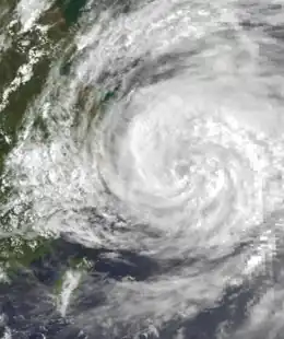
 Typhoon Holly on August 20 | |
| Formed | August 15, 1984 |
| Dissipated | August 24, 1984 |
| (Extratropical after August 22, 1984) | |
| Highest winds | 10-minute sustained: 130 km/h (80 mph) 1-minute sustained: 140 km/h (85 mph) |
| Lowest pressure | 960 hPa (mbar); 28.35 inHg |
| Fatalities | 19 dead or missing |
| Damage | $1 million (1984 USD) |
| Areas affected | South Korea, Japan, Soviet Union |
| Part of the 1984 Pacific typhoon season | |
In advance of the typhoon, ferry service between Jeju and mainland South Korea was called off, prompting 800 fishing boats to seek shelter. Throughout South Korea, nine people were killed or missing and hundreds lost their homes. At least 10 fishing boats were destroyed and hundreds of hectares of farmland were inundated. Across the Ryukyu Islands, 15,000 air travelers were stranded, including 14,000 from Okinawa when 23 flights were canceled. Between the Ryukyu Islands and the rest of Japan, ferry service was discontinued for two days, which resulted in 21,000 stranded passengers. Overall, one person was killed due to high waves in Nagasaki Prefecture, nine were listed as missing, and eleven were wounded. In all, damage was estimated at US$1 million. The extratropical remnants caused significant flooding in the Russian Far East. Water levels around Khabarovsk rose 10 m (33 ft) along the Amur River, resulting in the evacuation of 64 families, although 2,000 cows and pigs remain stranded. Elsewhere, in Arkhara, a dam along the Amur River burst, which caused the worst flooding in the region since 1928 and resulted in the evacuation of many isolated children by helicopter.
Meteorological history

Tropical storm (39–73 mph, 63–118 km/h)
Category 1 (74–95 mph, 119–153 km/h)
Category 2 (96–110 mph, 154–177 km/h)
Category 3 (111–129 mph, 178–208 km/h)
Category 4 (130–156 mph, 209–251 km/h)
Category 5 (≥157 mph, ≥252 km/h)
Unknown
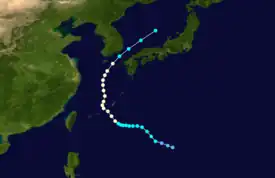
While Tropical Storm Gerald was forming in the South China Sea, the Western Pacific monsoon trough extended eastward in the middle of August 1984. By noon on August 13, the monsoon trough extended from Tropical Depression 9W to just northwest of Guam, and within 36 hours, this trough moved northwest and became sharper, with surface barometric pressures of 1000 mbar (30 inHg) and winds of 40 to 50 km/h (25 to 30 mph). Organization of the convection gradually improved and satellite imagery indicated that a surface low was forming. The Joint Typhoon Warning Center (JTWC) issued a Tropical Cyclone Formation Alert (TCFA) at 15:15 UTC on August 14. At 00:00 UTC on the next day, a Hurricane Hunter aircraft investigated the system, measuring a pressure of 998 mbar (29.5 inHg).[2] This prompted the Japan Meteorological Agency (JMA) to upgrade the low into a tropical depression.[3][nb 1]
At noon on August 15, synoptic data suggested that the system did not have a closed circulation; however, ship reports suggested that it was producing gale-force winds at the time. Early on August 16, a second aircraft investigated the system, finding a pressure of 992 mbar (29.3 inHg) and a closed circulation.[2] This promoted the JTWC to classify the system as Tropical Storm Holly while the JMA upgraded Holly directly to severe tropical storm.[5][nb 2] Despite its large size, Holly slowly deepened,[2] and was upgraded to a typhoon by the JMA at noon on August 17.[3] Nevertheless, Holly remained fairly disorganized, with aircraft observing light winds near the center and the strongest winds located in a rainband 110 to 280 km (70 to 175 mi) northeast from the center. It was not until August 18 that aircraft observed surface wind gusts of over 95 km/h (60 mph).[2] At 00:00 UTC that day, the JTWC upgraded Holly into a typhoon while the storm was located near Okinawa.[7]
After initially tracking westward under the influence of a subtropical ridge, Holly turned northwest for about a 30 hour period before turning north as it rounded the western side of the ridge.[2] At noon on August 19, the JTWC reported that Holly attained its peak intensity of 135 km/h (85 mph) while the JMA reported that Holly reached its highest winds of 130 km/h (80 mph) and a minimum pressure of 960 mbar (28 inHg). Shortly after its peak, Holly turned northeast while also accelerating in response to the westerlies, which sent the storm across the Korean Straits on a collision course with the Korean Peninsula. Land interaction with South Korea resulted in a weakening trend, with both the JTWC and JMA downgrading Holly to a tropical storm. Upon entering the Sea of Japan, Holly began to transition into an extratropical cyclone. The low-level circulation quickly became exposed from the center, and what little convection remained was far removed from the center, and attached to a cold front.[2] At 06:00 UTC on August 21, Holly was declared extratropical by the JMA,[3] with the JTWC following suit 12 hours later.[2] Two days later, the JMA had ceased tracking the cyclone altogether.[3]
Impact
Typhoon warnings were posted for Cheju Island and up to 80 km (50 mi) inland across South Korea. Ferry service between Cheju and the mainland was canceled due to the impeding threat of rough seas,[8] prompting 800 fishing boats to seek shelter.[8] Throughout South Korea, nine people were killed or missing and hundreds lost their homes. At least 10 fishing boats were demolished, hundreds of hectares of farmland were flooded, and several homes were damaged.[7]
In some places of the southern portion of the island of Kyushu, forecasters anticipated that up to 280 mm (11 in) of rain could fall.[9] Across the Ryukyu Islands, 15,000 air travelers were stranded.[10] In Naha, the main city in Okinawa, an estimated 14,000 tourists were stranded when all 23 scheduled flights to Japanese main islands were canceled.[9] Between the Ryukyu Islands and the Japanese mainland, ferry service was called off for two days, resulting in 21,000 stranded passengers.[8] Further north, in Itsuki, 31 people lost their homes. Forty-one flights were cancelled in Miyazaki Prefecture, which caused an additional 4,200 stranded travelers.[11] Overall, the storm dropped heavy rainfall across much of Japan.[12] A peak rainfall total of 708 mm (27.9 in) occurred at Ebino, including 338 mm (13.3 in) in a day.[13] Within 24 hours, 433 mm (17.0 in) of rain fell in Mount Yonaha, including 48 mm (1.9 in) an hour.[14] Moreover, a wind gust of 108 km/h (67 mph) was recorded in Mount Yonaha[15] while further south, wind gusts of 95 mph (153 km/h) were recorded in Okinawa.[9] Nation-wide, one person was killed due to high waves in Nagasaki,[16] nine were listed as missing,[2] and eleven were wounded, including nine in Okinawa and the western prefectures of Kumamoto, Nagaski, Yamaguchi, and Hiroshima while two in Aichi Province sustained injuries after strong winds toppled a tree. Property damage was estimated at US$1 million.[16]
The extratropical remnants caused significant flooding in the Russian Far East. Water levels around Khabarovsk along the Amur River rose 10 m (33 ft) to 51 m (167 ft), marking one of the few times the river reached that high since records began in the area in 1895.[17][18] Due to the subsequent flooding, 64 families were evacuated, although 2,000 cows and pigs were left stranded. Further west, in Arkhara, a dam along the Amur River burst its banks along a 20.1 km (12.5 mi) stretch, resulting in the river's worst flooding since 1928 and the evacuation of many stranded children in helicopters.[17]
See also
Notes
- The Japan Meteorological Agency is the official Regional Specialized Meteorological Center for the western Pacific Ocean.[4]
- Wind estimates from the JMA and most other basins throughout the world are sustained over 10 minutes, while estimates from the United States-based Joint Typhoon Warning Center are sustained over 1 minute. 10 minute winds are about 1.14 times the amount of 1 minute winds.[6]
References
- Padua, Michael V. (November 6, 2008). PAGASA Tropical Cyclone Names 1963–1988 (Report). Typhoon 2000. Retrieved June 22, 2018.
- Joint Typhoon Warning Center; Naval Western Oceanography Center (1985). Annual Tropical Cyclone Report: 1984 (PDF) (Report). United States Navy, United States Air Force. Retrieved June 24, 2018.
- Japan Meteorological Agency (October 10, 1992). RSMC Best Track Data – 1980–1989 (Report). Archived from the original (.TXT) on December 5, 2014. Retrieved June 24, 2018.
- "Annual Report on Activities of the RSMC Tokyo – Typhoon Center 2000" (PDF). Japan Meteorological Agency. February 2001. p. 3. Retrieved June 24, 2018.
- Kenneth R. Knapp; Michael C. Kruk; David H. Levinson; Howard J. Diamond; Charles J. Neumann (2010). 1984 Holly (1984225N18142). The International Best Track Archive for Climate Stewardship (IRACS): Unifying tropical cyclone best track data (Report). Bulletin of the American Meteorological Society. Retrieved June 24, 2018.
- Christopher W Landsea; Hurricane Research Division (April 26, 2004). "Subject: D4) What does "maximum sustained wind" mean? How does it relate to gusts in tropical cyclones?". Frequently Asked Questions. National Oceanic and Atmospheric Administration's Atlantic Oceanographic and Meteorological Laboratory. Retrieved June 24, 2018.
- Hong Kong Observatory (1983). "Part III – Tropical Cyclone Summaries". Meteorological Results: 1984 (PDF). Meteorological Results (Report). Hong Kong Observatory. Retrieved June 24, 2018.
- "International News". United Press International. August 20, 1984. – via Lexis Nexis (subscription required)
- "Typhoon heads toward southern Japan". United Press International. August 19, 1984. – via Lexis Nexis (subscription required)
- "Typhoon Holly Hits Okinawa". New York Times. August 19, 1984. – via Lexis Nexis (subscription required)
- "Typhoon bears down on Japan". United Press International. August 21, 1984. – via Lexis Nexis (subscription required)
- Asanobu, Kitamoto. Typhoon 198410 (Holly). Digital Typhoon (Report). National Institute of Informatics. Retrieved June 26, 2018.
- Asanobu, Kitamoto. AMeDAS EBINO (87346) @ Typhoon 198410. Digital Typhoon (Report). National Institute of Informatics. Retrieved June 26, 2018.
- Asanobu, Kitamoto. AMeDAS YONAHADAKE (91051) @ Typhoon 198410. Digital Typhoon (Report). National Institute of Informatics. Retrieved June 26, 2018.
- Asanobu, Kitamoto. AMeDAS OKINOERABU (88971) @ Typhoon 198410. Digital Typhoon (Report). National Institute of Informatics. Retrieved June 26, 2018.
- "Killer typhoon downgraded to tropical storm". United Press International. August 22, 1984. Retrieved May 9, 2020.
- "Severe Flooding In Far East, More Expected". Associated Press. August 24, 1984. – via Lexis Nexis (subscription required)
- "Flooding in the Soviet Far East". British Broadcast Corporation. August 25, 1984. – via Lexis Nexis (subscription required)