Uintah meridian
The Uintah meridian, also called the Uintah Special Meridian (USM) has a center point north of Roosevelt, Utah. The Uintah meridian was established in 1875, and governs land surveys in the Uintah and Ouray Indian Reservation in the state of Utah.
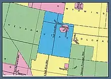
U.S. Bureau of Land Management map showing the principal meridians in Utah
References
External links
- "Cadastral Survey [Uintah Meridian]". U.S. Bureau of Land Management. Archived from the original on 2010-05-18. Retrieved 2012-10-06.
- "Principal Meridians and Base Lines". U.S. Bureau of Land Management. Archived from the original on 2012-10-18. Retrieved 2012-10-06.
- "Uintah Meridian". Principal Meridian Project. Retrieved 2012-10-06.
- "Uintah Special Meridian". The Center for Land Use Interpretation. Retrieved 2012-10-06.
- U.S. Geological Survey Geographic Names Information System: Uintah Meridian
This article is issued from Wikipedia. The text is licensed under Creative Commons - Attribution - Sharealike. Additional terms may apply for the media files.