Ulupna
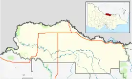
Ulupna is a locality in the north of the Australian state of Victoria. The locality is basically Ulupna Island, an inland island bordered by Ulupna Creek and the Murray River. The island is a popular camping destination. In 2016 the Population was 23. [2]
| Ulupna Victoria | |||||||||||||||
|---|---|---|---|---|---|---|---|---|---|---|---|---|---|---|---|
 Ulupna | |||||||||||||||
| Coordinates | 35°50′04″S 145°27′32″E | ||||||||||||||
| Population | 23 [1] (2016 census) | ||||||||||||||
| Postcode(s) | 3641 | ||||||||||||||
| LGA(s) | Shire of Moira | ||||||||||||||
| State electorate(s) | Shepparton | ||||||||||||||
| Federal division(s) | Nicholls | ||||||||||||||
| |||||||||||||||
The Ulupna post office opened on 10 February 1879, closed on 11 April 1892, reopened on 1896 and closed on 1 July 1926.[3] A school was opened in 1884 and closed in 1953[4]
References
- "2016 Ulupna, Census All persons QuickStats | Australian Bureau of Statistics". abs.gov.au. Retrieved 25 May 2022.
- "Ulupna suburb profile". landchecker.com.au. Retrieved 19 March 2021.
- Premier Postal History, Post Office List, retrieved 9 December 2009
- "Ulupna | Victorian Places". www.victorianplaces.com.au. Retrieved 19 March 2021.
This article is issued from Wikipedia. The text is licensed under Creative Commons - Attribution - Sharealike. Additional terms may apply for the media files.