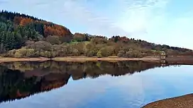
Upper Goyt Valley
The Upper Goyt Valley is the southern section of the valley of the River Goyt in North West England.[1]
| Upper Goyt Valley | |
|---|---|
 Fernilee Reservoir in the Goyt Valley | |
| Geography | |
| Location | Derbyshire and Cheshire, England |
| Coordinates | 53.2965°N 1.9805°W |
| Rivers | River Goyt |
Position
The source of the Goyt River is on Axe Edge Moor above Goyt's Moss to the south. The western side of the valley is a long ridge, running from Shining Tor to Windgather Rocks, which forms the county boundary between Derbyshire and Cheshire; the boundary formerly followed the river itself. The eastern side of the valley rises to Burbage Edge, overlooking Buxton, and Combs Moss.[2]

The old stone Derbyshire Bridge gets its name from it being at the historic boundary from Cheshire into Derbyshire. The road south out of the Goyt Valley is one-way and crosses the bridge.[3]
History
The Street Roman road runs alongside Errwood Reservoir and to the west of Fernilee Reservoir.
The disused Cromford and High Peak Railway line (which connected the High Peak canal at Whaley Bridge with the River Derwent in Cromford since 1831) runs along the east side of the reservoirs. This stretch of the railway line was closed in 1896.[4]
The Fernilee gunpowder mill operated in the valley from about 1800 at the site of Fernilee Reservoir. It was acquired in 1888 by Chilworth Gunpowder Company and expanded before closing in 1920, after numerous fatal accidents.[5]

Errwood Hall was the Victorian mansion of the Grimshawe family, built in about 1840 but it is now in ruins. Below Foxlow Edge there is a Spanish shrine, built in 1889 in memory of Miss Dolores (a friend of the Grimshawe family). The shrine is a designated Grade II listed building.[6]
A local legend tells that Pym Chair is the spot where a highway man called Pym robbed passers by on the packhorse route. However another story is that Pym was a preacher who gave sermons there.[7]
Reservoirs
The valley floor is now dominated by two drinking-water reservoirs, fed by the River Goyt. Both reservoirs were built by the Stockport Corporation Waterworks (after they acquired the Grimshawe estate) to provide drinking water for Stockport town and the surrounding area. Fernilee Reservoir was completed in 1938 and the hamlet of Goyt's Bridge and Errwood Hall were destroyed to prevent any pollution of the water. Errwood Reservoir was completed in 1967. A spectacular suspension bridge once crossed the river but it was demolished to make way for Errwood Reservoir. An old packhorse bridge was saved and reconstructed near Goytsclough Quarry. The reservoirs and much of the surrounding land is currently owned by United Utilities.[8][9]
Moorland
The open gritstone moorlands of the Upper Goyt Valley (Wild Moor, Goyt's Moss, Burbage Edge, Shining Tor to Cats Tor ridge and Hop Moor) are a designated Site of Special Scientific Interest (SSSI). Heather is the main plant but the heathland is habitat for a variety of native grasses, rushes, sedges and shrubs including bilberry, crowberry, cowberry and cross-leaved heath. Hare’s-tail cottongrass and sphagnum moss are common along the Shining Tor ridge. The area is important for upland breeding birds including a large population of golden plover, as well as red grouse, curlew, lapwing, whinchat, snipe, twite, ring ouzel and merlin. Along Goyt’s Clough (by the River Goyt from Derbyshire Bridge down to Errwood Reservoir) there are common sandpiper and dipper and the old commoner woodland includes oak, birch, rowan and alder.[10]
Tourism
The valley has been a popular tourist destination since the 19th century.[7]
Errwood Sailing Club operates at Errwood Reservoir.
The Peak District Boundary Walk from Buxton follows the disused railway line into the Valley from the south east, crosses the Errwood Dam and then tracks along the west side of the Fernilee reservoir.[11]
There are two large car parks in the central valley at The Street and Errwood Hall. There are smaller car parks at Derbyshire Bridge to the south and at the northern end of Fernilee Reservoir. There are extensive footpaths through the valley.[12]
See also
References
- "The Goyt Valley (Fact Sheet: 16)" (PDF). Peak District National Park Authority. Archived from the original (PDF) on 12 May 2013. Retrieved 28 April 2014.
- "The River Goyt". www.peakdistrictinformation.com. Retrieved 8 April 2016.
- "Derbyshire Bridge". Cheshire Now. Retrieved 24 March 2020.
- "Fernilee Reservoir". Wonders Of The Peak. Retrieved 22 March 2020.
- "Whaley Bridge History, Furnilee Powder Mills, Page 1". Whaley Bridge Local History. Retrieved 24 March 2020.
- Historic England. "WAYSIDE SHRINE AT SK 0070 7525 (1221410)". National Heritage List for England. Retrieved 26 September 2020.
- "History". Goyt Valley Online. Retrieved 22 March 2020.
- "Fernilee Reservoir in the Goyt valley". Derbyshire Heritage. Retrieved 22 March 2020.
- "History of the twin reservoirs | The Goyt Valley". The Goyt Valley. Retrieved 22 March 2020.
- "Goyt Valley SSSI" (PDF). Natural England. 31 January 1990. Retrieved 12 April 2020.
- "Boundary Walk". Friends of the Peak District. 12 October 2017. Retrieved 23 March 2020.
- Ordnance Survey: Landranger map sheet 119 Buxton & Matlock (Chesterfield, Bakewell & Dove Dale) (Map). Ordnance Survey. 2012. ISBN 9780319231890.