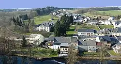
Useldange
Useldange (Luxembourgish: Useldeng [ˈuzəldeŋ]; German: Useldingen) is a commune and small town in western Luxembourg, in the canton of Redange.
Useldange
Useldeng | |
|---|---|
 | |
 Coat of arms | |
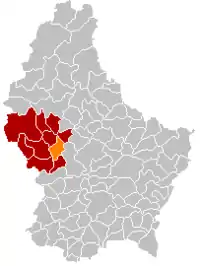 Map of Luxembourg with Useldange highlighted in orange, and the canton in dark red | |
| Coordinates: 49.7689°N 5.9808°E | |
| Country | |
| Canton | Redange |
| Area | |
| • Total | 23.92 km2 (9.24 sq mi) |
| • Rank | 37th of 102 |
| Highest elevation | 377 m (1,237 ft) |
| • Rank | 70th of 102 |
| Lowest elevation | 232 m (761 ft) |
| • Rank | 43rd of 102 |
| Population (2023) | |
| • Total | 2,075 |
| • Rank | 79th of 102 |
| • Density | 87/km2 (220/sq mi) |
| • Rank | 75th of 102 |
| Time zone | UTC+1 (CET) |
| • Summer (DST) | UTC+2 (CEST) |
| LAU 2 | LU0000708 |
| Website | useldange.lu |
As of 2021, the town of Useldange, which lies in the east of the commune, has a population of 1965. Other towns within the commune include Everlange, Rippweiler, and Schandel.
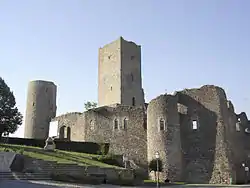
Useldange Castle is a medieval castle, which, while now being mainly in ruin, also comprises the current town hall. It is located in the centre of the village, right opposite to the town's church building. The site can be visited throughout the year with special arrangements for poorly sighted visitors.[1] It is also the location for the annual medieval festival in Luxembourg.
Useldange also has an airfield used by gliders (49.768611°N 5.965556°E).
Population
References
- "Château fort d'Useldange", Service des Sites et Monuments Nationaux. (in French) Retrieved 26 March 2011.
- "Population par canton et commune". statistiques.public.lu. Retrieved 11 January 2022.
External links
 Media related to Useldange at Wikimedia Commons
Places adjacent to Useldange | ||||||||||||||||
|---|---|---|---|---|---|---|---|---|---|---|---|---|---|---|---|---|
| ||||||||||||||||
 | ||