Uvari
Uvari is a coastal village in Thisayanvilai[1] Taluk, Tirunelveli district, Tamil Nadu, India. It is also called Karaichuthu Uvari.[2][3] The total geographical area of the Uvari is around 3 km2 (1.2 sq mi).
Uvari | |
|---|---|
Village | |
 Uvari Location in Tamil Nadu, India | |
| Coordinates: 8.286205°N 77.899305°E | |
| Country | |
| State | Tamil Nadu |
| District | Tirunelveli district |
| Elevation | 12.44 m (40.81 ft) |
| Population (2001) | |
| • Total | 25,000 |
| Languages | |
| • Official | Tamil |
| Time zone | UTC+5:30 (IST) |
History
According to Tamil history, the citizens of Uvari were called Bharathar's of the Neithal (ocean land) World. Uvari's historical name was Ophir. It was ruled by the Pandyan dynasty. Suyambulingaswamy Temple - a renowned Hindu temple - is located here. This temple is estimated to be at least 500 to 1000 years old.
In the 1530s, Portuguese and Spanish missionaries from Goa which includes Saint Francis Xavier arrived here and converted many Bharathars the Fishermans to the Roman Catholic religion. The Portuguese priests, acting as godfathers,baptized them in the name of Lord and gave them surnames such as Fernando to the converted. Pandya retains a fish on its flag, a symbol of this era.
Legend has it that the crew of a Portuguese ship that sailed near Uvari in the seventeenth century contracted cholera. In an attempt to avert death, a carpenter aboard the ship carved an image of Saint Anthony (Anthony of Padua).[4] Soon after, the entire crew were restored to health. When the ship docked at Uvari, the sailors placed the statue inside a hut in the village. In the 1940s, the villagers built a church with the original statue of St. Anthony holding the infant Jesus in his hand. St Anthony the Saint of Crore Miracles is said to perform many miracles daily for the people who flock there with faith in his intercession, therefore the church was upgraded to a Major shrine.[5] This Church in Uvari is visited by Hindus , Muslims and Christians from all over the world
Geography
Uvari is surrounded by the village Idaiyangudi at North, Navaladi at West , karachithuvari at East and the Bay of Bengal Sea at South. The mean maximum temperature is around 37 °C (99 °F) in summer and 17 °C (63 °F) in winter, with humidity levels over 65 percent. The rainy season starts between October and January. Uvari is rich in mineral resources like limestone, Ilmenite, and red garnet sands.[6]
Facilities
Two hospitals are located in Uvari.
- St. Joseph Hospital Missionary
- Government Primary Healthcare Hospital
An Canara bank is located in Uvari. (with ATM)[7][8]
Post Office (627651)[9] BSNL Telephone Exchange (277 series).
SCHOOLS:-
1 - Malaviya Vidya Kendram School
2 - St.Mary's Boys primary school
3 - St.Joseph Girls school
4 - St.Mary's Higher secondary school
Landmarks
Suyambulingaswamy Temple, a sacred holy hindu temple is located here worshipped by Hindu communities from all around this place and from neighbourhood districts.
Uvari is home to the Roman catholic christians
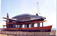
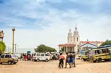
St. Antony's major Shrine church, a wonderful Catholic church also called as place of Crore Miracles by pilgrims is dedicated to St. Anthony of Padua. The selva madha church which is also called as Kappal Matha Church, is in the form of a ship carrying an aeroplane which is of an excellent architecture is viewed by so many tourists and pilgrims all around the world , it is also noted as one of best view site of govt of Tamilnadu Tourism .[10] The original church of St. Mary was damaged by sea erosion and replaced by this one, built in 1974. Uvari features Mainly four Churches and many grottos which are get viewed by more enormous number of tourists and pilgrims all around the Universe.
Transport
Uvari is 80 km (50 mi) from Thoothukudi, 40 km (25 mi) from Tiruchendur, 54 km (34 mi) from Nagercoil, 48 km (30 mi) from Kaniyakumari, 75 km (47 mi) from Tirunelveli, 230 km (140 mi) from Madurai, and 260 km (160 mi) from Rameswaram.
The village has no train service. The nearest railway's stations are located in Tiruchendur, 40 km (25 mi) away, and Kaniyakumari, 48 km (30 mi) away. The nearest airports are Tuticorin Airport, 100 km (62 mi) away and Trivandrum airport which is of 120 km
References
- "Karichuthu Uvari Revenue Village" (PDF). Official Tirunelveli District Website. Tamilnadu Government. Retrieved 31 August 2020.
- "Karaichuthu Uvari village in Thisaiyanvilai taluk". Official Tirunelveli District Government Website. Tamilnadu Government. Retrieved 31 August 2020.
- "Karichuthu Uvari Revenue Village" (PDF). Official Tirunelveli District Website. Tamilnadu Government. Retrieved 31 August 2020.
- "Anthony of Padua". britannica.com. Retrieved 31 August 2020.
- Vernacular Catholicism, vernacular saints : Selva J. Raj on "Being Catholic the Tamil way". Raj, Selva J., Locklin, Reid B. Albany. 27 March 2017. ISBN 978-1-4384-6505-0. OCLC 956984843.
{{cite book}}: CS1 maint: location missing publisher (link) CS1 maint: others (link) - "DISTRICT SURVEY REPORT FOR ROUGH STONE TIRUNELVELI DISTRICT" (PDF). Government of Tamil Nadu, Department of Geology and Mining. 2019. Retrieved 27 August 2020.
- "Central Bank of India Branch Locator". www.centralbankofindia.co.in. Central Bank of India. Retrieved 20 July 2020.
- "Uvari Canara Bank Branch". Canara Bank Branch Locator. Retrieved 20 July 2020.
- "India Post Pincode Locator service". /www.indiapost.gov.in. Retrieved 20 July 2020.
- "Uvari Kappal Matha Church | Tirunelveli District, Government of Tamil Nadu | India".
External links
- "Uvari details and Suyambulinga Swamy temple". Archived from the original on 30 January 2019.
- "Uvari Images & information".
- "Uvari Kappel Matha Church".
- Uvari on Facebook
- Official website