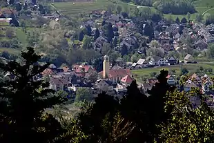
Varnhalt
Varnhalt is a village to the north of the town of Steinbach in southwestern Germany. Since 1972, Varnhalt has become a suburb of the spa town of Baden-Baden, together with Steinbach and Neuweier.[1] In 2004, the population of Varnhalt was about 2000.
Geography
The location of Varnhalt is carved deep into the foothills and mountains of the Northern Black Forest. Varnhalt is about 2 miles away from the center of the town of Steinbach (Baden). It can be reached locally from Steinbach via the Gallenbacher-Strasse. The village is situated at an altitude of 204 meters on the western slope of mount Yberg (517 m).
Economy
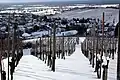
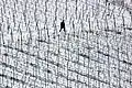
Viticulture and the wine trade are the main sources of income of its inhabitants. The hills and their high quality soil offer perfect conditions for growing a variety of fruits. Wine is grown in the steep hills facing South; the sun penetrates the dense leaves much better, which results in improved levels of sugar and alcohol, respectively, critical for a good wine. This has elevated the region to one of the top wine growing regions in Germany, with Riesling the predominant grape varieties grown.
History
As the name Varnhalt and its earlier name or spelling "Fahrenhalt" implies, the origin of the village was as the location where the farmers from Steinbach kept the local Farre (from middle-high German phar/var), Farren, Fasel, or Bull. Originally, the village was an agglomerate of a few individual farmsteads, which were loosely connected. Over the centuries these farmsteads grew together to become the village of Varnhalt, together with the farmsteads of the hamlock of Gallenbach.
Historic family names of inhabitants of the village of Varnhalt have been compiled in a family book. The winemaker or vintner family names are: Benz/Binz, Bilger, Dresel, Eckstein, Ernst, Frank, Hagenunger, Huck, Greys, Liebich, Lörch, Lorenz, Mast, Maier, Reiss, Schmalz, Werner, Zäpfel, and Zwingert.
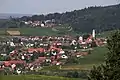
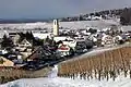
Photo gallery
- Baden-Baden-Varnhalt


References
- Das Baden-Badener Rebland unter der Yburg