Villeloin-Coulangé
Villeloin-Coulangé (French pronunciation: [vil.lwɛ̃ kulɑ̃ʒe]) is a commune in the Indre-et-Loire department in central France.
Villeloin-Coulangé | |
|---|---|
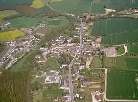 An aerial view of Villeloin-Coulangé | |
Location of Villeloin-Coulangé | |
 Villeloin-Coulangé  Villeloin-Coulangé | |
| Coordinates: 47°08′29″N 1°13′27″E | |
| Country | France |
| Region | Centre-Val de Loire |
| Department | Indre-et-Loire |
| Arrondissement | Loches |
| Canton | Loches |
| Intercommunality | CC Loches Sud Touraine |
| Government | |
| • Mayor (2020–2026) | Maryse Garnier[1] |
| Area 1 | 34.62 km2 (13.37 sq mi) |
| Population | 583 |
| • Density | 17/km2 (44/sq mi) |
| Time zone | UTC+01:00 (CET) |
| • Summer (DST) | UTC+02:00 (CEST) |
| INSEE/Postal code | 37277 /37460 |
| Elevation | 92–144 m (302–472 ft) |
| 1 French Land Register data, which excludes lakes, ponds, glaciers > 1 km2 (0.386 sq mi or 247 acres) and river estuaries. | |
Geography
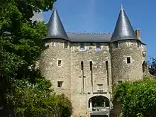
Former Saint-Sauveur abbey in Villeloin-Coulangé.
The Indrois flows northwest through the commune and crosses the village.
Population
|
|
References
- "Répertoire national des élus: les maires". data.gouv.fr, Plateforme ouverte des données publiques françaises (in French). 2 December 2020.
- "Populations légales 2020". The National Institute of Statistics and Economic Studies. 29 December 2022.
Wikimedia Commons has media related to Villeloin-Coulangé.
This article is issued from Wikipedia. The text is licensed under Creative Commons - Attribution - Sharealike. Additional terms may apply for the media files.