Wadi Seidna
Wadi Seidna (Arabic: وادي سيّدنا, romanized: wadi sayyidna), also spelled Wadi Sayyidna, is a wadi located in north of Omdurman, in Khartoum state, Sudan. It is notable for its association with the Sudanese Military Academy[1] and Wadi Seidna Air Base, which has been a subject of rescue missions and operations,[2] including those carried out by the Indian Air Force to evacuate personnel during the 2023 war in Sudan.[3]
Wadi Seidna
وادي سيّدنا | |
|---|---|
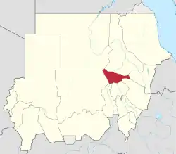
 Location in Sudan (Khartoum highlighted) | |
| Coordinates: 15°49′39″N 32°31′35″E | |
| Country | Sudan |
| State | Khartoum |
| City | Omdurman |
| Elevation | 383 m (1,257 ft) |
| Time zone | Central Africa Time, GMT + 3 |
| Geocode | 364126 |
The land around Wadi Seidna is flat, and is covered in the lower east. The highest place in the area has an altitude of 434 meters and is 2.5 km south of Wadi Seidna. There are about 47 people per square kilometer around Wadi Seidna, a relatively small population. The nearest larger town is Omdurman, 17.8 km south of Wadi Seidna. The area around Wadi Seidna is almost covered with houses. In the region around Wadi Seidna, islands, and hills are remarkably common.[4]
| Wadi Seidna, Omdurman | ||||||||||||||||||||||||||||||||||||||||||||||||||||||||||||
|---|---|---|---|---|---|---|---|---|---|---|---|---|---|---|---|---|---|---|---|---|---|---|---|---|---|---|---|---|---|---|---|---|---|---|---|---|---|---|---|---|---|---|---|---|---|---|---|---|---|---|---|---|---|---|---|---|---|---|---|---|
| Climate chart (explanation) | ||||||||||||||||||||||||||||||||||||||||||||||||||||||||||||
| ||||||||||||||||||||||||||||||||||||||||||||||||||||||||||||
| ||||||||||||||||||||||||||||||||||||||||||||||||||||||||||||
The climate is hot. The average temperature is 31 °C (88 °F). The hottest month is April, at 35 °C (95 °F), and the coldest is January, at 24 °C (75 °F). The average rainfall is 248 millimeters per year. The wettest month is August, with 113 millimeters of rain, and the driest is January, with 1 millimeter.[5]
References
- "Sudan: A Country Study". Federal Research Division, Library of Congress. 1992. Retrieved 29 July 2023.
 This article incorporates text from this source, which is in the public domain.
 - "اشتباكات السودان: الجيش يقاتل من أجل الاحتفاظ بالقاعدة الجوية في وادي سيدنا". BBC News عربي (in Arabic). Retrieved 2023-09-15.
- "IAF's Dramatic Aerial Rescue of 121 Indians From Wadi Sayyidna in Sudan Has Been Long in the Making". The Wire. Retrieved 2023-09-15.
- Peel, M. C.; Finlayson, B. L.; McMahon, T. A. (2007-10-11). "Updated world map of the Köppen-Geiger climate classification". Hydrology and Earth System Sciences. 11 (5): 1633–1644. doi:10.5194/hess-11-1633-2007. ISSN 1027-5606.
- Peel, M. C.; Finlayson, B. L.; McMahon, T. A. (2007-10-11). "Updated world map of the Köppen-Geiger climate classification". Hydrology and Earth System Sciences. 11 (5): 1633–1644. doi:10.5194/hess-11-1633-2007. ISSN 1027-5606.