Waipawa River
The Waipawa River is a braided river of southern Hawke's Bay, in New Zealand's eastern North Island.[1] It flows from the slopes of 1,687 m (5,535 ft) Te Atuaoparapara (once known as 'Sixty-six')[2] in the Ruahine Range southeast past the town of Waipawa before joining the Tukituki River.[3] The river rises at the 1,326 m (4,350 ft) Waipawa Saddle, which is also the source of the Waikamaka River.[4] West of Waipawa, near Ruataniwha,[5] the Mangaonuku Stream is a tributary on the northern bank. The Waipawa's flow is generally greater than that of the Tukituki River, into which it flows.[6]
| Waipawa River | |
|---|---|
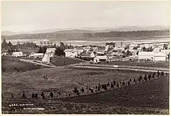
 Waipawa town and river in 1885 | |
| Location | |
| Country | New Zealand |
| Physical characteristics | |
| Source | |
| • location | Ruahine Range |
| • elevation | 1,687 m (5,535 ft) |
| Mouth | |
• location | Tukituki River |
• elevation | 120 m (390 ft) |
| Length | 57 km (35 mi) |
| Basin features | |
| Tributaries | |
| • left | Makaroro River Mangaonuku Stream |
The Old Bed of Waipawa River flows roughly parallel with and north of the present Waipawa River to join the Tukituki through the Papanui Stream, south west of Lake Poukawa.[7] The Waipawa changed its course during a flood in 1868.[8] It reverted to its old course during Cyclone Gabrielle in February 2023, until the Coronation Park stop bank in Waipawa was repaired on 16 February, returning the Waipawa to its post 1868 course.[9]
River quality is sampled at the SH50 bridge. At that site its Macroinvertebrate Community Index is C (of grades A to D) and likely degrading, but it is in the best 25% of rivers for most samples, except clarity. In warm weather cyanobacteria sometimes develop.[10] Other main routes crossing the river are SH2 and the Palmerston North–Gisborne railway at Waipawa.[11]
There are hundreds of banded dotterel (pohowera) and pied stilt around the river.[1]
Waipawa Forks Hut provides accommodation close to the headwaters of the river.[12] On the ridge to the north, above the headwaters, is Sunrise Hut. It is the most popular hut in the Ruahine Park and was renovated in 2020.[13] A day walk is possible, via Sunrise and the Saddle.[14]
References
- "Waipawa River" (PDF). Hawkes Bay Regional Council. 2018.
- "Te Atuaoparapara". gazetteer.linz.govt.nz. Retrieved 19 August 2021.
- "Te Atuaoparapara, Manawatu-Wanganui". NZ Topo Map. Retrieved 18 August 2021.
- "Waipawa Saddle, Hawke's Bay". NZ Topo Map. Retrieved 18 August 2021.
- "Ruataniwha, Hawke's Bay". NZ Topo Map. Retrieved 19 August 2021.
- "Recreational River Survey. Water & soil miscellaneous publication no. 13 (1981)" (PDF). NIWA.
- "Old Bed of Waipawa River, Hawke's Bay". NZ Topo Map. Retrieved 19 August 2021.
- "LATEST TELEGRAMS. HAWKE'S BAY HERALD". paperspast.natlib.govt.nz. 27 June 1868. Retrieved 19 August 2021.
- "Central Hawke's Bay District Council". www.facebook.com. 16 February 2023. Retrieved 27 February 2023.
- "Waipawa Rv at SH50 River Quality". Land, Air, Water Aotearoa (LAWA). Retrieved 18 August 2021.
- "Waipawa, Wellington". NZ Topo Map. Retrieved 18 August 2021.
- "Waipawa Forks Hut". www.doc.govt.nz. Retrieved 19 August 2021.
- "Popular Sunrise Hut revamped". www.doc.govt.nz. Retrieved 19 August 2021.
- "A challenging day tramp in the Ruahine Ranges". Napier Tramping Club. 2 December 2017. Retrieved 19 August 2021.