Wang Nam Khu
Wang Nam Khu (Thai: วังน้ำคู้) is a subdistrict in the Mueang Phitsanulok District of Phitsanulok Province, Thailand. In 2022 it had a population of 4,052 and 1,679 households. The economy of this subdistrict is mainly based on agriculture.
Wang Nam Khu
วังน้ำคู | |
|---|---|
|
Seal | |
| Country | Thailand |
| Province | Phitsanulok |
| District | Mueang Phitsanulok |
| Government | |
| • Type | Subdistrict Administrative Organization (SAO) |
| Area | |
| • Total | 24.0 km2 (9.3 sq mi) |
| Population (2022)[1] | |
| • Total | 4,052 |
| • Density | 168/km2 (440/sq mi) |
| Time zone | UTC+7 (ICT) |
| Postal code | 65000 |
| Calling code | 055 |
| Geocode | 65010200 |
| Website | www |
Geography
The topography of Wang Nam Khu subdistrict is flat plains and is located in the lower northern part of Thailand.[2] The subdistrict is bordered to the north by Wat Phrik subdistrict, to the east by Bang Krathum district, to the south by Bang Krathum district and to the west by Ngio Ngam subdistrict.[3] Wang Nam Khu subdistrict lies in the Nan Basin, which is part of the Chao Phraya Watershed. The Nan River flows on the boundary of Wang Nam Khu and Ngio Ngam subdistricts.
Administration
Central government
The administration of ฺWang Nam Khu subdistrict (tambon) is responsible for an area that covers 15,002 rai ~ 24.0 square kilometres (9.3 sq mi) and consists of eight administrative villages (muban). As of 2022: 4,052 people and 1,679 households.[1][4]
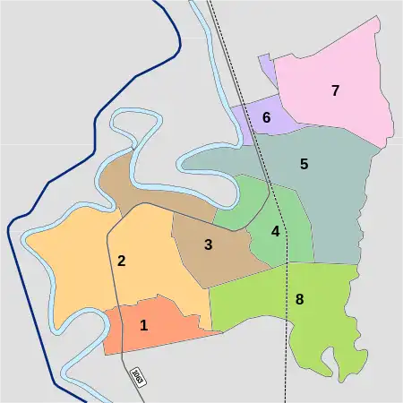
| Village | English | Thai | People | Households |
|---|---|---|---|---|
| Moo1 | Ban Wang Yang | บ้านวังยาง | 623 | 219 |
| Moo2 | Ban Pak Phing Tawan Ook | บ้านปากพิงตะวันออก | 536 | 194 |
| Moo3 | Ban Pak Don | บ้านปากดอน | 483 | 207 |
| Moo4 | Ban Bang Kwan Ma | บ้านบางขวัญม้า | 484 | 205 |
| Moo5 | Ban Khung Wang | บ้านคุ้งวัง | 846 | 391 |
| Moo6 | Ban Bang Sai | บ้านบางทราย | 38 | 20 |
| Moo7 | Ban Phai Long Rat Charoen | บ้านไผ่หลงราษฎร์เจริญ | 631 | 279 |
| Moo8 | Ban Nong Ya | บ้านหนองหญ้า | 411 | 164 |
Temples
Wang Nam Khu subdistrict is home to the following active temples, where Theravada Buddhism is practised by local residents:[5]
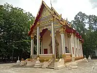
| Temple name | Thai | Location |
|---|---|---|
| Wat Pak Phing Tawan Ook | วัดปากพิงตะวันออก | Moo2 |
| Wat Pak Don | วัดปากดอน | Moo3 |
| Wat Bang Sai | วัดบางทราย | Moo6 |
| Wat Phai Long Rat Charoen | วัดไผ่หลงราษฎร์เจริญ | Moo7 |
Economy
Most of the people are engaged in agriculture of which rice is the main crop.[6]
Education
The following schools are located in Wang Nam Khu subdistrict.[7]
- Ban Wang Yang school - Moo1
- Wang Nam Khu Sueksa school - Moo4
- Ban Nong Ya school - Moo8
Healthcare
- Wang Nam Khu health-promoting hospital in Moo3.[8]
Transport
- National road 1063, Phitsanulok-Bang Krathum
Electricity
All households in Wang Nam Khu subdistrict have access to the electricity grid of Provincial Electricity Authority (PEA).[9]
Waterworks
All households in Wang Nam Ku subdistrict have access to the water network of Provincial Waterworks Authority (PWA).[10]
References
- "Official statistics registration systems". Department of Provincial Administration. Retrieved 6 June 2023, year 2022 >village level >ExcelFile >no.65010201-65010208 >Excel line 70297-70305
{{cite web}}: CS1 maint: postscript (link) - "สภาพภูมิประเทศ" [terrain] (in Thai). Retrieved 6 June 2023.
- "อาณาเบตติดต่อ" [contact territory] (in Thai). Retrieved 6 June 2023.
- "เขตการปกครอง" [subdivision] (in Thai). Retrieved 6 June 2023, these village names are from 2015, out of date today!
{{cite web}}: CS1 maint: postscript (link) - "list of temples". Retrieved 6 June 2023, > no.28700 - 28704
{{cite web}}: CS1 maint: postscript (link) - "อาชีพในตำบล" [occupation in subdistrict] (in Thai). Retrieved 6 June 2023.
- "การศึกษาในตำบล" [subdistrict education] (in Thai). Retrieved 6 June 2023.
- "การสาธารณสุข" [public health] (in Thai). Retrieved 6 June 2023.
- "ไฟฟ้าในตำบล" [electricity in subdistrict] (in Thai). Retrieved 6 June 2023.
- "ประปาในตำบล" [water supply subdistrict] (in Thai). Retrieved 6 June 2023.