Wangtu
Wangtu is a town situated in Kinnaur, Himachal Pradesh, India, its geographical coordinates are 31° 33' 0" North, 78° 1' 0" East and its original name (with diacritics) is Wangtu. The nearest airport is in Shimla, which is approximately 200 km from Wangtu. It is very close to the Indo-China border, and located on the Old Hindustan-Tibet Road. Wangtu was affected by the 1975 Kinnaur earthquake.
Wangtu | |
|---|---|
Town | |
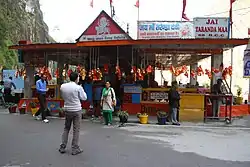 Temple of Kali | |
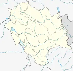 Wangtu Location in Himachal Pradesh, India  Wangtu Wangtu (India) | |
| Coordinates: 31°33′N 78°1′E | |
| Country | |
| State | Himachal Pradesh |
| District | Kinnaur |
| Elevation | 1,823 m (5,981 ft) |
| Population | |
| • Total | 3,000 |
| Languages | |
| • Official | Hindi |
| Time zone | UTC+5:30 (IST) |
| Nearest city | Reckong Peo, Rampur, Kalpa, Pooh, Nichar, Morang, Katgaon(Bhaba). |
| Lok Sabha constituency | Mandi |
| Vidhan Sabha constituency | Kinnur |
| Climate | Cold (Köppen) |
External links
This article is issued from Wikipedia. The text is licensed under Creative Commons - Attribution - Sharealike. Additional terms may apply for the media files.