Water of Leith
The Water of Leith (Scottish Gaelic: Uisge Lìte) is the main river flowing through central Edinburgh, Scotland, that starts in the Pentlands Hills and flows into the port of Leith and then into the sea via the Firth of Forth.
| Water of Leith | |
|---|---|
 | |
| Location | |
| Sovereign state | United Kingdom |
| Country | Scotland |
| Council areas | West Lothian, Edinburgh |
| Physical characteristics | |
| Source | |
| • location | Millstone Rig, West Lothian |
| • coordinates | 55°59′N 3°10′W |
| Mouth | |
• location | Leith Docks, Edinburgh |
• coordinates | 55.979399°N 3.170638°W |
• elevation | 0 m (0 ft) |
| Length | 35 km (22 mi) |
Name
The name Leith may be of Brittonic origin and derived from *lejth meaning 'damp, moist' (Welsh llaith).[1] It is less likely that the name derives from the Old Norse lodda meaning a river. The Gaelic form of the name is Lìte (Leith), with Uisge Lìte being the full translation of "Water of Leith".[2]
The Dictionary of the Scots Language defines the term "water" here as "A large stream, usu. thought of as intermediate in size between a Burn and a river."[3]
Course

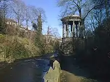
The length of the main stream is 20 miles (31.7 km). Its source is the Colzium Springs in the Pentland Hills.[4] The river travels through Harperrig Reservoir, past the ruins of Cairns Castle, on to Balerno, Currie, Juniper Green, Colinton, Slateford, Longstone, Saughton, Balgreen, Roseburn and West Coates. The river nears Edinburgh city centre between West End and Dean Village; the site of old watermills in a deep gorge. The ravine is dramatically spanned by the Dean Bridge, designed by Thomas Telford and built in 1832 for the road to Queensferry.[5]

The river flows on past Stockbridge, Inverleith, Canonmills and Warriston where it passes through shallows at a place known as Puddocky which is commonly thought to refer to "puddocks", the Scots language term for frogs,[6] but actually took its name from the former Paddock Hall sited nearby.[7] The river continues past Bonnington, the site of another watermill, to Leith where it widens into the old harbour and port at the Shore. Leith Docks have been extended considerably out into the firth from the old shoreline.
Water of Leith Walkway
The Water of Leith Walkway is beside the river for 12.8 miles (20.6 km) from Balerno to Leith.[8] The route forms an attractive haven for wildlife, passing through areas of woodland, often well separated from roads. For some distance the walkway follows the route of former railway tracks, and the remains of tunnels, bridges and other features of more than one railway may be seen at many places along the route including the Colinton Tunnel Mural.[9]
Water of Leith Conservation Trust
The Water of Leith Conservation Trust, founded in 1988 is a registered charity whose objective is to "conserve the Water of Leith and its environs" and "promote the natural and built heritage of the river . . . ".[10] The Trust runs educational programs and operates a visitor centre close to where the Union Canal passes over the Water of Leith via the Slateford Aqueduct in south-west Edinburgh.
Wildlife

The river contains 15 different types of fish including brown trout, wild grayling, eels, stone loach, minnow, three-spined stickleback and flounder. A few sea-trout run the river, and occasional Atlantic salmon are reported, although those from which scale samples have been obtained have turned out to be from other catchments.
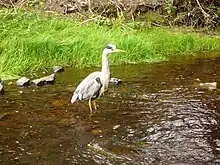
Until the weirs are either demolished or furnished with effective fish-passes, there is little chance of a population of salmon establishing themselves in this river again. Roe deer, badgers, otters and other mammals are often seen.[8] The river and its environs are the haunt of a wide variety of woodland and water birds, including kingfisher, grey heron, pied wagtail, great spotted woodpecker and white-throated dipper.
See also
- Rivers of Scotland
- River Almond, which flows through Cramond and Kirkliston
- River Esk, Lothian
- Water of Leith, a river which flows through Dunedin, New Zealand
References
- James, Alan. "A Guide to the Place-Name Evidence" (PDF). SPNS - The Brittonic Language in the Old North. Retrieved 25 November 2018.
- Bell, Raymond MacKean (2017). Literary Corstorphine: A reader's guide to West Edinburgh. Edinburgh: Leamington Books. ISBN 9780244644406.
- "Water". Dictionary of the Scots Language. Retrieved 2 August 2020.
- Helen Brown (3 April 2020). Water of Leith Management Plan 2020-2030 (pdf) (Report). Water of Leith Action Group. p. 4. Retrieved 22 August 2023.
- Historic Environment Scotland. "Edinburgh, Queensferry Road, Dean Bridge (119344)". Canmore. Retrieved 23 August 2023.
- "Dictionaries of the Scots Language:: SND :: puddock". Retrieved 22 August 2023.
- Ashford, Zella (1994). "The Lands of Warriston" (PDF). The Book of the Old Edinburgh Club Journal for Edinburgh History. 3: 1. ISSN 2634-2618.
- The Water of Leith Conservation Trust. "Welcome - A silver thread in a ribbon of green". www.waterofleith.org.uk. Retrieved 14 October 2020.
- "Home". www.colintontunnel.org.uk. Retrieved 22 August 2023.
- "The Trust » The Water of Leith Conservation Trust". The Water of Leith Conservation Trust. Retrieved 23 August 2023.
External links
- Water of Leith Conservation Trust: The River, Visitor Center, Education, Conservation
- Scottish Government, 16/03/07: Water of Leith Flood Prevention Scheme
- Water of Leith
- Water of Leith Millennium Bid document. The bid was successful and paid for new sections of the Walkway and the Visitor Centre.
- "Forth District Salmon Fishery Board"
- "River Forth Fisheries Trust"