Waterfront station (Washington Metro)
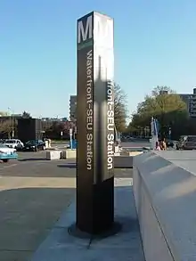
Waterfront station (known as Waterfront–SEU from 1997 to 2011) is a Washington Metro station in the Southwest Waterfront neighborhood of Washington, D.C., United States. The station was opened on December 28, 1991, and is operated by the Washington Metropolitan Area Transit Authority (WMATA). Waterfront is located in the Southwest Waterfront neighborhood at the intersection of 4th and M Streets SW.
Waterfront | |||||||||||
|---|---|---|---|---|---|---|---|---|---|---|---|
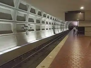 Waterfront station platform | |||||||||||
| General information | |||||||||||
| Location | 399 M Street SW Washington, D.C. | ||||||||||
| Owned by | Washington Metropolitan Area Transit Authority | ||||||||||
| Platforms | 1 island platform | ||||||||||
| Tracks | 2 | ||||||||||
| Connections |
| ||||||||||
| Construction | |||||||||||
| Structure type | Underground | ||||||||||
| Bicycle facilities | Capital Bikeshare, 10 racks and 12 lockers | ||||||||||
| Accessible | Yes | ||||||||||
| Other information | |||||||||||
| Station code | F04 | ||||||||||
| History | |||||||||||
| Opened | December 28, 1991 | ||||||||||
| Previous names | Waterfront (1991–1997) Waterfront–SEU (1997–2011) | ||||||||||
| Passengers | |||||||||||
| 2022 | 1,670 daily[1] | ||||||||||
| Rank | 47th | ||||||||||
| Services | |||||||||||
| |||||||||||
| Location | |||||||||||
Notable places nearby
History
Much of the physical construction of the station was complete by 1980,[2] and its opening was initially to occur in 1983.[3] However, due to litigation surrounding where the line would terminate in Prince George's County, planning and construction of the Green Line halted in 1981 and would not resume until 1985.[4] The station opened on December 28, 1991, and coincided with the completion of approximately 2.88 miles (4.63 km) of rail southeast of the L'Enfant Plaza station and the opening of the Anacostia and Navy Yard – Ballpark stations.[5]
Name changes
The station was renamed Waterfront–SEU in 1997, referring to the nearby Southeastern University. Southeastern University closed in 2009, and the station reverted to the Waterfront name on November 3, 2011.[6]
Station layout
The station has an island platform with a single escalator bank entrance north of the intersection of 4th and M Streets.
| G | Street level | Exit/entrance, buses |
| M | Mezzanine | Fare gates, ticket machines, station agent |
| P Platform level |
Southbound | ← |
| Island platform | ||
| Northbound | | |
References
- "Rail Ridership Data Viewer". WMATA. Retrieved February 12, 2023.
- Feaver, Douglas B. (December 13, 1980), "Metro board agrees to make Green Line a top priority", The Washington Post, p. B1
- Feaver, Douglas B. (November 19, 1978), "Metro completion expected in 10 years", The Washington Post, p. B10
- McQueen, Michel (March 17, 1982), "Judge blocks Metro route; Rosecroft shift", The Washington Post, p. C1
- Tousignant, Marylou (December 29, 1991), "After feuds, amid fanfare, Metro rolls into Anacostia", The Washington Post, p. B1
- "Station names updated for new map" (Press release). Washington Metropolitan Area Transit Authority. November 3, 2011. Archived from the original on November 5, 2011. Retrieved November 5, 2011.
External links
 Media related to Waterfront (WMATA station) at Wikimedia Commons
- WMATA Waterfront station page
- The Schumin Web Transit Center: Waterfront Station
- 4th Street entrance from Google Maps Street View