Wendelstein, Bavaria
Wendelstein is a municipality in the district of Roth, in Bavaria, Germany, located about 12 kilometres (7.5 mi) southeast of Nuremberg.
Wendelstein | |
|---|---|
 Coat of arms | |
Location of Wendelstein within Roth district 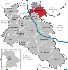 | |
 Wendelstein 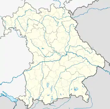 Wendelstein | |
| Coordinates: 49°21′13″N 11°8′54″E | |
| Country | Germany |
| State | Bavaria |
| Admin. region | Mittelfranken |
| District | Roth |
| Government | |
| • Mayor (2020–26) | Werner Langhans[1] (CSU) |
| Area | |
| • Total | 51.08 km2 (19.72 sq mi) |
| Elevation | 330 m (1,080 ft) |
| Population (2022-12-31)[2] | |
| • Total | 16,089 |
| • Density | 310/km2 (820/sq mi) |
| Time zone | UTC+01:00 (CET) |
| • Summer (DST) | UTC+02:00 (CEST) |
| Postal codes | 90530 |
| Dialling codes | 09129 |
| Vehicle registration | RH |
| Website | www.wendelstein.de |
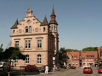
Center of Wendelstein
Geography
Wendelstein is about 13 km south-southeast of the center of the city of Nuremberg in the Schwarzach Valley. To the north it borders Nuremberg, to the east Feucht, Schwarzenbruck and Pyrbaum, to the south Allersberg and Schwanstetten and to the west Rednitzhembach and Schwabach. The municipal area also includes an uninhabited exclave, one square kilometer in size, of Lorenzer Reichswald north of a former ammunition dump, Heeresmunitionsanstalt Feucht.
Climate
| Climate data for Wendelstein (1991–2020 normals) | |||||||||||||
|---|---|---|---|---|---|---|---|---|---|---|---|---|---|
| Month | Jan | Feb | Mar | Apr | May | Jun | Jul | Aug | Sep | Oct | Nov | Dec | Year |
| Average high °C (°F) | −0.5 (31.1) |
−1.3 (29.7) |
0.7 (33.3) |
4.1 (39.4) |
9.2 (48.6) |
12.2 (54.0) |
14.0 (57.2) |
14.3 (57.7) |
10.4 (50.7) |
7.8 (46.0) |
2.9 (37.2) |
−0.2 (31.6) |
6.2 (43.2) |
| Daily mean °C (°F) | −3.6 (25.5) |
−4.4 (24.1) |
−2.4 (27.7) |
0.8 (33.4) |
5.7 (42.3) |
8.6 (47.5) |
10.4 (50.7) |
10.8 (51.4) |
7.2 (45.0) |
4.5 (40.1) |
−0.1 (31.8) |
−3.2 (26.2) |
2.9 (37.2) |
| Average low °C (°F) | −6.2 (20.8) |
−7.0 (19.4) |
−5.0 (23.0) |
−1.8 (28.8) |
2.9 (37.2) |
5.6 (42.1) |
7.4 (45.3) |
8.1 (46.6) |
4.7 (40.5) |
1.8 (35.2) |
−2.7 (27.1) |
−5.8 (21.6) |
0.2 (32.4) |
| Average precipitation mm (inches) | 123.3 (4.85) |
143.5 (5.65) |
178.9 (7.04) |
117.7 (4.63) |
129.8 (5.11) |
183.2 (7.21) |
185.5 (7.30) |
176.5 (6.95) |
127.1 (5.00) |
92.0 (3.62) |
135.0 (5.31) |
139.6 (5.50) |
1,729.5 (68.09) |
| Average precipitation days (≥ 1.0 mm) | 15.3 | 15.6 | 19.1 | 16.6 | 18.2 | 19.9 | 18.7 | 16.9 | 15.6 | 14.3 | 15.0 | 17.6 | 202.4 |
| Average relative humidity (%) | 67.2 | 71.4 | 77.0 | 76.7 | 77.7 | 79.8 | 79.9 | 78.3 | 79.2 | 71.5 | 72.7 | 71.7 | 75.3 |
| Mean monthly sunshine hours | 120.6 | 117.2 | 133.9 | 154.2 | 179.1 | 167.8 | 186.2 | 194.0 | 152.8 | 154.0 | 106.4 | 97.4 | 1,775.4 |
| Source: World Meteorological Organisation[3] | |||||||||||||
References
- Liste der ersten Bürgermeister/Oberbürgermeister in kreisangehörigen Gemeinden, Bayerisches Landesamt für Statistik, 15 July 2021.
- Genesis Online-Datenbank des Bayerischen Landesamtes für Statistik Tabelle 12411-003r Fortschreibung des Bevölkerungsstandes: Gemeinden, Stichtag (Einwohnerzahlen auf Grundlage des Zensus 2011)
- "World Meteorological Organization Climate Normals for 1991–2020". World Meteorological Organization Climatological Standard Normals (1991–2020). National Oceanic and Atmospheric Administration. Archived from the original on 12 October 2023. Retrieved 13 October 2023.
External links
 Media related to Wendelstein at Wikimedia Commons
Towns and municipalities in Roth (district) | ||
|---|---|---|
This article is issued from Wikipedia. The text is licensed under Creative Commons - Attribution - Sharealike. Additional terms may apply for the media files.