Rathmannsdorf
Rathmannsdorf is a township in the Saxon district of Sächsische Schweiz-Osterzgebirge. Rathmannsdorf is 2 km (1 mi) down the Elbe from Bad Schandau.
Rathmannsdorf | |
|---|---|
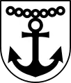 Coat of arms | |
Location of Rathmannsdorf within Sächsische Schweiz-Osterzgebirge district 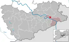 | |
 Rathmannsdorf  Rathmannsdorf | |
| Coordinates: 50°56′N 14°08′E | |
| Country | Germany |
| State | Saxony |
| District | Sächsische Schweiz-Osterzgebirge |
| Municipal assoc. | Bad Schandau |
| Subdivisions | 5 |
| Government | |
| • Mayor (2022–29) | Uwe Thiele[1] (CDU) |
| Area | |
| • Total | 4.37 km2 (1.69 sq mi) |
| Elevation | 225 m (738 ft) |
| Population (2021-12-31)[2] | |
| • Total | 893 |
| • Density | 200/km2 (530/sq mi) |
| Time zone | UTC+01:00 (CET) |
| • Summer (DST) | UTC+02:00 (CEST) |
| Postal codes | 01814 |
| Dialling codes | 035022 |
| Vehicle registration | PIR |
| Website | www.rathmannsdorf.de |
Geography
The township's highest point is a plateau near Bad Schandau 200 meters above sea level, with the lowest point 120 meters above sea level along the Elbe. The township consists of the districts Wendischfähre, Höhe, Zauke, Plan and Gluto.[3]
History
Rathmannsdorf was first mentioned in a document in 1443. Rathmannsdorf along with Bad Schandau, Porschdorf, and Reinhardtsdorf-Schöna form a Verwaltungsgemeinschaft. The town is also a stop on the Sebnitztalbahn part of the Sächsische Semmering-Bahn, a local railroad.
References
- Gewählte Bürgermeisterinnen und Bürgermeister im Freistaat Sachsen, Stand: 17. Juli 2022, Statistisches Landesamt des Freistaates Sachsen.
- "Bevölkerung des Freistaates Sachsen nach Gemeinden am 31. Dezember 2021" (XLS) (in German). Statistisches Landesamt des Freistaates Sachsen. 2022.
- "Community information". Gemeinde Rathmannsdorf in the center of the Elbsandsteingebirge. Gemeinde Rathmannsdorf. Retrieved 2 February 2019.
This article is issued from Wikipedia. The text is licensed under Creative Commons - Attribution - Sharealike. Additional terms may apply for the media files.