Westland Tai Poutini National Park
Westland Tai Poutini National Park is a national park located on the western coast of New Zealand's South Island. Established in 1960 as Westland National Park to commemorate the centenary of the European settlement of Westland District, it covers 1,320 square kilometres (330,000 acres) of largely mountainous terrain and forest.[1][2] The park borders the Aoraki/Mount Cook National Park along the Main Divide of the Southern Alps / Kā Tiritiri o te Moana, and includes many of the West Coast's glaciers, most notably including the Fox / Te Moeka o Tuawe and Franz Josef / Kā Roimata o Hine Hukatere glaciers.
| Westland Tai Poutini National Park | |
|---|---|
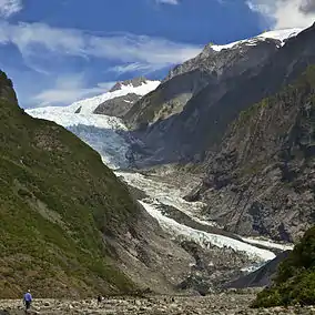 Franz Josef Glacier in 2011 | |
Interactive map of Westland Tai Poutini National Park | |
| Location | West Coast, New Zealand |
| Coordinates | 43°23′S 170°11′E |
| Area | 1,319.8 km2 (509.6 sq mi) |
| Established | 1960 |
| Governing body | Department of Conservation |
| Official name | Te Wāhipounamu – South West New Zealand |
| Type | Natural |
| Criteria | vii, viii, ix, x |
| Designated | 1990 (14th session) |
| Reference no. | 551 |
| Region | Oceania |
The small tourist towns of Fox Glacier and Franz Josef / Waiau are the main settlements within the park, while remnants of old gold mining towns can be found along the coast. The park offers hunting opportunities for red deer, chamois, and tahr, while helicopters allow hunters to access the rugged, mountainous areas. The popular Copland Track runs upstream from the Karangarua River bridge. Along with the mountain scenery visible from the track, there are hot springs at Welcome Flat Hut.[3]
The park has been progressively expanded since its establishment, largely through incorporating nearby forest reserves or other conservation land. Ōkārito and Waikukupa State Forests were added to the park in 1982, followed by the upper Karangarua Valley in 1983, North Ōkārito and Saltwater State Forests in 2002, and over 4,400 hectares (11,000 acres) of other land scattered throughout the park in 2010.[4][5]
Geography
Westland Tai Poutini National Park covers 1,320 square kilometres (510 sq mi) exclusively on the western side of the South Island's main divide, making it New Zealand's fifth largest national park. The park covers a wide variety of environments, ranging from high alpine tundra near the park's border with Aoraki / Mount Cook National Park to coastal wetlands around Ōkārito Lagoon. This contributes to a large variation in elevation within the park, which extends from sea level to 3,498 metres (11,476 ft) at Mount Tasman.[6] The mountains are also responsible for the high degree of orographic rainfall which occurs in the park due to the prevailing westerlies, contributing in turn to the dense temperate rainforest found throughout the park.[7]
References
- "Westland Tai Poutini National Park". Department of Conservation. Retrieved 7 December 2018.
- "Data Table - Protected Areas - LINZ Data Service". Land Information New Zealand. Retrieved 18 October 2017.
- "Copland Track to Welcome Flat Hut". Retrieved 18 November 2019.
- "Historic Westland Tai Poutini". www.doc.govt.nz. Retrieved 9 July 2022.
- "New additions to Westland National Park" (Press release). New Zealand Government. 17 June 2010. Retrieved 7 December 2018 – via Scoop.
- "Westland Tai Poutini National Park | national park, New Zealand | Britannica". www.britannica.com. Retrieved 9 July 2022.
- Kerr, Tim; Henderson, Roddy; Sood, Abha (2018). "The precipitation distribution across Westland Tai Poutini National Park". Journal of Hydrology (New Zealand). 57 (1): 1–23. ISSN 0022-1708. Retrieved 9 July 2022.