Woodcroft, Edmonton
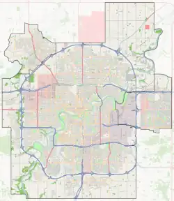
Woodcroft is a neighbourhood located in northwest Edmonton, Alberta, Canada. Surrounded by a mixture of residential neighbourhoods and light industrial subdivisions, it is bounded by 118 Avenue to the north, Groat Road to the east, 111 Avenue to the south, and 142 Street to the west. The neighbourhoods is home to Coronation Park and the Telus World of Science.

Woodcroft | |
|---|---|
Neighbourhood | |
 Woodcroft Location of Woodcroft in Edmonton | |
| Coordinates: 53.567°N 113.558°W | |
| Country | |
| Province | |
| City | Edmonton |
| Quadrant[1] | NW |
| Ward[1] | Anirniq |
| Sector[2] | Mature area |
| Government | |
| • Administrative body | Edmonton City Council |
| • Councillor | Erin Rutherford |
| Area | |
| • Total | 1.29 km2 (0.50 sq mi) |
| Elevation | 676 m (2,218 ft) |
| Population (2012)[5] | |
| • Total | 2,598 |
| • Density | 2,014/km2 (5,220/sq mi) |
| • Change (2009–12) | |
| • Dwellings | 1,395 |
The six residential neighbourhoods adjacent to Woodcroft include Dovercourt to the north, Sherbrooke to the northeast, Inglewood to the east, Westmount to the southeast, North Glenora to the south, and McQueen to the southwest. Huff Bremner Estate and Dominion Industrial are located to the west and northwest.
The community is represented by the Woodcroft Community League, established in 1957, which maintains a community hall and outdoor rink located at 139 Street and 115 Avenue.[6][7]
Demographics
In the City of Edmonton's 2012 municipal census, Woodcroft had a population of 2,598 living in 1,395 dwellings,[5] a -0.7% change from its 2009 population of 2,617.[8] With a land area of 1.29 km2 (0.50 sq mi),[4] it had a population density of 2,014 people/km2 in 2012.[4][5]
Attractions

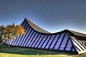
Coronation Park is a large park occupying most of the southwest portion of the neighbourhood. The park is anchored by the Telus World of Science, formerly the Edmonton Space and Sciences Centre, at the northeast corner of 111 Avenue and 142 Street. Other attractions within the park include the Queen Elizabeth Planetarium, an ice arena, a small football stadium, a lawn bowling facility and the Peter Hemingway Fitness and Leisure Centre, formerly the Coronation Pool.
The neighbourhood is also home to the Woodcroft Branch of the Edmonton Public Library.
Shopping
Westmount Centre, built in 1955, is located in the southeast portion of the neighbourhood at the northwest corner of 111 Avenue and Groat Road. It was the first major shopping mall of its type in Edmonton.
Education
Located between Coronation Park and the Westmount Centre is Ross Sheppard High School operated by Edmonton Public Schools. Other schools in Woodcroft include Woodcroft Public Elementary School and the St. Mark Catholic School.
Westmount Transit Centre
Westmount Transit Centre | |
|---|---|
| General information | |
| Platforms | 11 bus bays[9] |
| Construction | |
| Parking | No |
| Bicycle facilities | Yes |
| Accessible | Yes |
| Other information | |
| Website | Westmount Transit Centre |
The Westmount Transit Centre is located between Ross Sheppard High School and Westmount Centre along 135 street. This transit centre has a large shelter, a pay phone and vending machines but does not have public washrooms, park & ride, or a drop off area.[10] The transit centre is served by Edmonton Transit Service (ETS) and St. Albert Transit (StAT).
The following bus routes serve the transit centre:[11][12]
| To/From | Routes | |
|---|---|---|
| Acheson | 561 | ETS |
| Calder | 51 | ETS |
| Castle Downs Transit Centre | 51 | ETS |
| Coliseum Transit Centre | 5 | ETS |
| Downtown | 5 | ETS |
| Jasper Place Transit Centre | 52, 908, 909 | ETS |
| Kingsway/Royal Alex Transit Centre | 125 | ETS |
| Mistatim Industrial | 121, 124 | ETS |
| NAIT | 561 | ETS |
| Northgate Transit Centre | 52, 905 | ETS |
| North-West Industrial | 906, 907 | ETS |
| Stadium Transit Centre | 3 | ETS |
| St. Albert Centre Exchange | 203 | StAT |
| St. Albert Nakî Transit Centre | 203 | StAT |
| University Transit Centre | 51, 203 | ETS, StAT |
| West Edmonton Mall Transit Centre | 904, 906, 907 | ETS |
| White Industrial | 906 | ETS |
References
- "City of Edmonton Wards & Standard Neighbourhoods" (PDF). City of Edmonton. Archived from the original (PDF) on May 3, 2014. Retrieved February 13, 2013.
- "Edmonton Developing and Planned Neighbourhoods, 2011" (PDF). City of Edmonton. Retrieved February 13, 2013.
- "City Councillors". City of Edmonton. Retrieved February 13, 2013.
- "Neighbourhoods (data plus kml file)". City of Edmonton. Retrieved February 22, 2013.
- "Municipal Census Results – Edmonton 2012 Census". City of Edmonton. Retrieved February 22, 2013.
- "Hall Rentals". Woodcroft Community League. Retrieved October 14, 2017.
- Kuban, Ron (2005). Edmonton's Urban Villages: The Community League Movement. University of Alberta Press. ISBN 9781459303249.
- "2009 Municipal Census Results". City of Edmonton. Retrieved February 22, 2013.
- "Westmount Transit Centre Map" (PDF). City of Edmonton. Retrieved 2 December 2018.
- "Westmount Transit Centre". City of Edmonton. Retrieved October 2, 2017.
- "Brochures in PDF". City of Edmonton. Retrieved 1 September 2019.
- "Commuter Routes". City of St. Albert. Retrieved 2 December 2018.