White Ruthenia
White Ruthenia (Belarusian: Белая Русь, romanized: Biełaja Ruś; Polish: Ruś Biała; Russian: Белая Русь, romanized: Bjelaja Ruś; Ukrainian: Біла Русь, romanized: Bila Ruś) alternatively known as Russia Alba, White Rus' or White Russia, is an archaism[1][2] for the eastern part of present-day Belarus, including the cities of Polotsk, Vitebsk and Mogilev.
History
Many other variations of this name appeared on ancient maps; for instance, Russia Alba, Russija Alba, Wit Rusland, Weiß Reußen (Weißreußen), White Russia, Hviterussland, Hvíta Rússland, Weiß Russland (Weißrussland), Ruthenia Alba, Ruthénie Blanche and Weiß Ruthenien (Weißruthenien). The name was also assigned to various territories, often quite distant from that of present Belarus.
According to Alfred Nicolas Rambaud:
The name of White (Lithuanian: Balta) Russia is given to the provinces conquered from the 13th to the 14th century by the Grand Dukes of Lithuania. These were the ancient territories of the Krivitches, Polotchans, Dregovitches, Drevlians, Doulebes, now forming the governments of Vitepsk, Mohilef, and Minsk. The Lithuanian territories of Grodno, Novogrodek and Belostok were sometimes called Black Russia.[3]
An ethno-religious theory suggests that the name used to describe the part of old Ruthenian lands within the Grand Duchy of Lithuania that had been populated mostly by Slavs who had been Christianized early, as opposed to Black Ruthenia, which was predominantly inhabited by pagan Balts.[4]
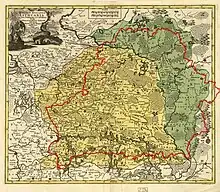
_(3).jpg.webp)
On the 1712 map of French cartographer Henri Chatelain "Russie noire" (Black Ruthenia) is placed in region of Eastern Galicia (today Western Ukraine), which traditionally known as "Russie rouge" (Red Ruthenia).

Vasmer's dictionary mentions the dichotomy of "white" land and "taxed" land in Domostroy and speculates that "white" Rus' may have referred to the parts of Kievan Rus' that were not conquered by Golden Horde. Another speculation in Vasmer is that the color of the clothes of the White Ruthenians (perhaps as well as the color of their hair) may have contributed to the name. Oleg Trubachyov calls both theories "complete fantasies".
Also, the 16th century chronicler Alexander Guagnini's book Sarmatiae Europeae descriptio wrote that Rus' was divided in three parts. The first part, under the rule of the Muscovite Grand Duke, was called White Ruthenia. The second one, under the rule of Polish king, was called Black Ruthenia. And the rest was Red Ruthenia. He also said Moscow was the center of White Rus' and the Russian metropolitanate, and that the Grand Duke of Moscow was called the White Czar, especially by his subjects.
References
- "White Russia". Oxforddictionaries.com. 2013. Archived from the original on 30 August 2017. Retrieved 24 October 2017.
- "White Russian". Oxforddictionaries.com. 2017. Archived from the original on 30 August 2017. Retrieved 24 October 2017.
- Rambaud, Alfred (1898). "2". History of Russia. Archived from the original on 2021-08-31. Retrieved 2021-08-31.
- Аб паходжанні назваў Белая і Чорная Русь (Eng. "About the Origins of the Names of White and Black Ruthenia"), Язэп Юхо (Joseph Juho), 1956.
Sources
- Akta Aleksandra, króla polskiego, wielkiego księcia litewskiego i t.d. (1501—1506). Wyd. F. Papee. Kraków, 1927
- Alexandrowicz S. Rozwój kartografii Wielkiego Księstwa Litewskiego od XV do połowy XVIII w. Poznań, 1989
- Anonymi Dvbnicensis. Liber de rebus Lvdovici R. H.. Analecta Monumentorum Hungariae historicum literarorium maximum inedita. Budapestini, 1986
- I.V. Bellum Prutenum. Smereka E. Zbiór pisarzy polsko–lacińskich. Leopoli, 3, 1933
- Colker M. L. America rediscovered in thirteenth century?. Speculum. A journal of medieval studies. Cambridge. Vol. 54. No. 4. October 1979
- Cosmographey oder beschreibung aller Laender, Herrschaften, fürnemsten Stetten... Beschriben durch Sebastianum Münsterum... Basel, 1550; Ulrichs von Richental Chronik des Constanzer Concils 1414 bis 1418. Herausgegeben von M. R. Buck. Tübingen, 1882
- Cromer M. Polonia sive de situ, populis, moribus, magistratibus et republica regni Poloni libri duo. Cracoviae, 1901. (паўтоp выданьня 1578 г.)
- Der Weiss Kunig. Eine Erzählung von den Thaten Kaiser Maximilian der Ersten. Wien, 1775
- Historica Russiae monumenta ex antiquis exterarum gentium arcivis et bibliothecis deprompta ab A. I. Turgenevio. V. I. Petropoli, 1841 (Акты исторические, относящиеся к России, извлечённые из иностранных архивов и библиотек А. И. Тургеневым)
- Historiae Ruthenicae Scriptores exteri saeculi XVI. V. I—II. Berolini et Petropoli, 1841—42
- Kronika Jana z Czarnkowa (Joannis de Czarnkow. Chronicon Polonorum). Оprac. J. Szlachtowski. Monumenta Poloniae Historica Lwów, T. II. 1872
- Nordenskiöld, Adolf Erik Facsimile-Atlas to the Early History of Cartography with Reproductions of the Most Important Maps Printed in the XV and XVI Centuries. Stockholm, 1889. Замысловский Е. Е. Геpбеpштейн и его истоpико–геогpафические известия о России. СПб., 1884
- Il Mappamondo di Fra Mauro. A cura di Tullio Gasparini Leporace. Presentazione di Roberto Almagia. Venezia, 1956
- Ioannes Stobnicensis. Introductio in Ptolomei Cosmographiam. Cracoviae, 1512
- Ostrowski W. About the origin of the name «White Russia». London, 1975
- Peter Suchenwirt’s Werke aus dem vierzehnten Jahrhundert. Hrsg. von Alois Primisser. Wien, 1827
- Prisschuch Th. Des conzilis grundveste. Die historischen Volkslieder der Deutschen vom 13. bis 6. Jahrhundert. Bd. 1. Leipzig, 1865
- Prochaska A. Codex epistolaris Vitoldi. Cracoviae, 1882
- Rude & barbarous kingdom. Russia in the accounts of sixteenth-century English voyagers. Ed. by Lloyd E. Berry and Robert O. Crummey. Madison—London, 1968
- Sarmatiae Europeae descriptio. Ab Alexandro Guagnino Veronensi. Poloniae Historiae Corpus. Ex bibliotheca Ioan. Pistorii Nidani. Per Sebastiani Henric Petri. V. I. Basileae, 1588
- Scriptores Rerum Hungaricarum tempore ducum regumque stirpis Arpadianae gestarum. Vol. II. Budapest, 1938
- Starowolski Sz. Polska albo opisanie położenia królestwa Polskiego. Kraków, 1976
- Stryikowski M. Kronika Polska, Litewska, Żmódzka i wszystkiej Rusi. T. I-II. Warszawa, 1846
- Witkowska M. H. S. Vita sanctae Kyngae ducissae Cracoviensis. Roczniki Humanistyczne. T. X, z. 2. Lublin, 1961.
- Імя тваё «Белая Русь». Мн., 1991
- Опись архива Посольского приказа 1626 г. Ч. 1. М., 1977
- Порецкий Я. И. Соломон Рысинский * Solomo Pantherus Leucorussus. Мн., 1983
- ПСРЛ. Т. 2. СПб., 1843; Т. 25. М.—Л., 1949
- Рыбаков Б. А. Русские карты Московии XV — начала XVI в. М., 1974
- Савельева Е. А. Hовгоpод и Hовгоpодская земля в западноевропейской каpтогpафии XV—XVI вв.. Геогpафия России XV—XVIII вв. (по сведениям иностpанцев). Л., 1984
- Слово избpанное от святых писаний еже на латыню. Попов А. Н. Историко–литературный обзор дpевнеpусских полемических сочинений пpотив латинян. М., 1875