Whitemarsh Island, Georgia
Whitemarsh Island (/ˈhwɪtmɑːrʃ/; WHIT-marsh) is a census-designated place (CDP) in Chatham County, Georgia, United States. The population was 6,983 at the 2020 U.S Census.[1] It is part of the Savannah Metropolitan Statistical Area. The communities of Whitemarsh Island are a relatively affluent suburb of Savannah.
Whitemarsh Island, Georgia | |
|---|---|
 | |
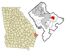 Location in Chatham County and the state of Georgia | |
| Coordinates: 32°2′22″N 81°0′28″W | |
| Country | United States |
| State | Georgia |
| County | Chatham |
| Area | |
| • Total | 6.65 sq mi (17.21 km2) |
| • Land | 5.82 sq mi (15.06 km2) |
| • Water | 0.83 sq mi (2.15 km2) |
| Elevation | 3 ft (0.9 m) |
| Population (2020) | |
| • Total | 6,983 |
| • Density | 1,200.86/sq mi (463.64/km2) |
| Time zone | UTC-5 (Eastern (EST)) |
| • Summer (DST) | UTC-4 (EDT) |
| FIPS code | 13-82636[3] |
| GNIS feature ID | 1867247[2] |
Geography
The Whitemarsh Island CDP is located at 32°2′22″N 81°0′28″W (32.039482, -81.007850),[4] occupying the island of the same name. It is bordered to the north by Richardson Creek, to the east by Turner Creek, and to the south and west by the Wilmington River, all of which are tidal water bodies. U.S. Route 80 crosses the island, leading west into Savannah and east to Tybee Island on the Atlantic shore. The Islands Expressway runs northwest from Whitemarsh Island 6.5 miles (10.5 km) to downtown Savannah.
According to the United States Census Bureau, the Whitemarsh Island CDP has a total area of 6.6 square miles (17.2 km2), of which 5.6 square miles (14.6 km2) is land and 1.0 square mile (2.6 km2), or 15.10%, is water.[5]
Demographics
| Census | Pop. | Note | %± |
|---|---|---|---|
| 1990 | 2,824 | — | |
| 2000 | 5,824 | 106.2% | |
| 2010 | 6,792 | 16.6% | |
| 2020 | 6,983 | 2.8% | |
| source:[6][5] | |||
2020 census
| Race | Num. | Perc. |
|---|---|---|
| White (non-Hispanic) | 5,497 | 78.72% |
| Black or African American (non-Hispanic) | 379 | 5.43% |
| Native American | 12 | 0.17% |
| Asian | 455 | 6.52% |
| Pacific Islander | 2 | 0.03% |
| Other/Mixed | 378 | 5.41% |
| Hispanic or Latino | 260 | 3.72% |
As of the 2020 United States census, there were 6,983 people, 2,752 households, and 1,704 families residing in the CDP.
2000 census
As of the census[3] of 2000, there were 5,824 people, 2,302 households, and 1,609 families residing in the CDP. The population density was 987.5 inhabitants per square mile (381.3/km2). There were 2,427 housing units at an average density of 411.5 per square mile (158.9/km2). The racial makeup of the CDP was 82.19% White, 9.24% African American, 0.26% Native American, 5.75% Asian, 0.12% Pacific Islander, 1.01% from other races, and 1.43% from two or more races. Hispanic or Latino of any race were 2.40% of the population.
There were 2,302 households, out of which 34.8% had children under the age of 18 living with them, 59.1% were married couples living together, 7.7% had a female householder with no husband present, and 30.1% were non-families. 22.6% of all households were made up of individuals, and 4.2% had someone living alone who was 65 years of age or older. The average household size was 2.53 and the average family size was 2.99.
In the CDP, the population was spread out, with 25.0% under the age of 18, 7.8% from 18 to 24, 34.8% from 25 to 44, 23.9% from 45 to 64, and 8.5% who were 65 years of age or older. The median age was 36 years. For every 100 females, there were 96.2 males. For every 100 females age 18 and over, there were 95.9 males.
The median income for a household in the CDP was $58,087, and the median income for a family was $73,704. Males had a median income of $47,083 versus $32,055 for females. The per capita income for the CDP was $31,529. About 1.2% of families and 5.0% of the population were below the poverty line, including 2.1% of those under age 18 and 4.0% of those age 65 or over.
Neighborhoods
Long Point Plantation is located on Whitemarsh Island, just east of the intersection of US HWY 80 and Johnny Mercer Boulevard. It can be reached by driving east on US 80 or from the Islands Expressway.
Housing costs on Whitemarsh Island range from $150,000 to upwards of $2,900,000.
Education
It is in Savannah-Chatham County Public Schools.[8] Schools include:
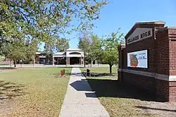
- Islands High School[9]
- Coastal Middle School[10]
- Marshpoint Elementary School[11]
Live Oak Public Libraries operates the Islands Library.[12]
 Coastal Middle School
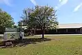 Marshpoint Elementary School
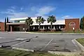 Live Oak Public Libraries, Whitemarsh Island
References
- "2020 U.S. Gazetteer Files". United States Census Bureau. Retrieved December 18, 2021.
- U.S. Geological Survey Geographic Names Information System: Whitemarsh Island, Georgia
- "U.S. Census website". United States Census Bureau. Retrieved January 31, 2008.
- "US Gazetteer files: 2010, 2000, and 1990". United States Census Bureau. February 12, 2011. Retrieved April 23, 2011.
- "Geographic Identifiers: 2010 Demographic Profile Data (G001): Whitemarsh Island CDP, Georgia". U.S. Census Bureau, American Factfinder. Archived from the original on February 12, 2020. Retrieved July 24, 2014.
- "CENSUS OF POPULATION AND HOUSING (1790-2000)". U.S. Census Bureau. Retrieved July 31, 2010.
- "Explore Census Data". data.census.gov. Retrieved December 14, 2021.
- "2020 CENSUS - SCHOOL DISTRICT REFERENCE MAP: Chatham County, GA" (PDF). U.S. Census Bureau. Retrieved March 19, 2023. - Text list
- "Home". Islands High School. Retrieved March 19, 2023.
170 Whitemarsh Island Road Savannah, GA 31410
- Despite the Savannah address, it is in the Whitemarsh Island CDP. - "Home". Coastal Middle School. Retrieved March 19, 2023.
4595 US Highway 80 East Savannah, GA 31410
- Despite the Savannah address, it is in the Whitemarsh Island CDP. - "Home". Marshpoint Elementary School. Retrieved March 19, 2023.
135 Whitemarsh Island Road Savannah, GA 31410
- Despite the Savannah address, it is in the Whitemarsh Island CDP. - "Islands". Live Oak Public Libraries. Retrieved March 19, 2023.
Municipalities and communities of Chatham County, Georgia, United States | ||
|---|---|---|
| Cities |  Map of Georgia highlighting Chatham County | |
| Towns | ||
| CDPs | ||
| Unincorporated communities | ||