Whitfield, Derbyshire
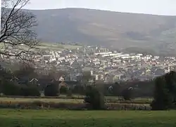
Whitfield is a hamlet and former parish in Derbyshire, England. It is half a mile (1km) south of Glossop Town Hall, south of Glossop Brook between Bray Clough and Hurst Brook.[1] Whitfield was one of the original townships in the ancient Parish of Glossop. Up to the latter part of the 18th century the hamlet was devoted mostly to agriculture with an area of 2,608 statute acres.[2] The area rises from about 169m[3] to about 266m[4] above mean sea level.
| Whitfield | |
|---|---|
 Whitfield | |
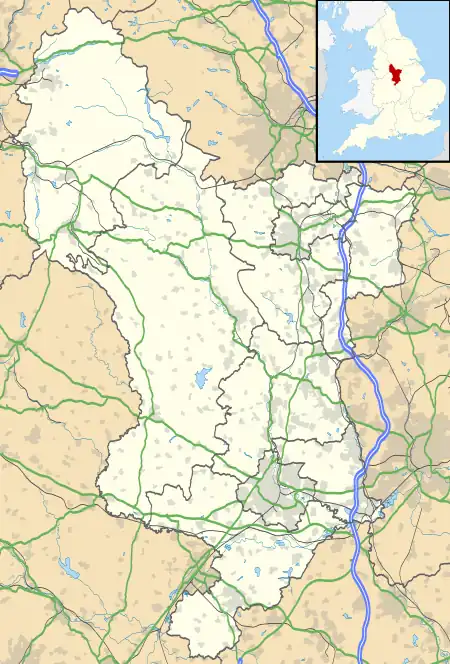 Whitfield Location within Derbyshire | |
| OS grid reference | SK034938 |
| District | |
| Shire county | |
| Region | |
| Country | England |
| Sovereign state | United Kingdom |
| Post town | GLOSSOP |
| Postcode district | SK13 |
| Police | Derbyshire |
| Fire | Derbyshire |
| Ambulance | North West |
| UK Parliament | |
Natural England maps
Maps showing Access, Designations and other criteria from Natural England:[lower-alpha 1]
- MAGiC MaP : Whitfield – Hob Hill.[5]
- MAGiC MaP : Whitfield – spot height 169.2m – Charlestown Road.[3]
- MAGiC MaP : Whitfield – spot height 205.7m – Hague Street.[6]
- MAGiC MaP : Whitfield – spot height 266.1m – Hob Hill.[4]
- MAGiC MaP : Whitfield – parish boundary.[7]
- MAGiC MaP : Dark Peak – Pennine Way – Mill Hill.[9][lower-alpha 2]
Name
Name history
The name was recorded as Witfeld in the Domesday Book of 1086 A.D.[10]
Survey of English Place-Names:[11]
Name toponym
The name element wit is from Old English wiht ("weight")[lower-alpha 3] which itself is derived from Latin vectis ("lever").[lower-alpha 4][lower-alpha 5]
The name element feld is from Old English feld ("field").[lower-alpha 6]
The toponym might be:
- Landmass that lifts upwards.[lower-alpha 7][lower-alpha 8]
- Field that elevates up a hill.
- Field that rises towards the sky.
Examples of place names that may have a similar etymology include the Isle of Wight – "the island that lifts up out of the sea".
History
The Manor of Whitfield was conveyed in 1330 to John Foljambe. Though held with the manor of Glossop, the land in Whitfield was mostly not part of the Norfolk estate unlike most of the manor of Glossop. When it was enclosed by act of parliament in 1810 it was recorded as being 1,577 acres (6.38 km2). Included in Whitfield are the villages of Charlestown and Littlemoor.
The Turnlee Paper factory was in Littlemoor. St James, Littlemoor, was consecrated in 1845[13] and is built in the Early English style, with tower and 114-foot (35 m) spire. There is a Methodist Chapel at Whitfield; the Wesleyan Reformers and Independent Calvinists had chapels at Littlemoor.[14]
When Glossop expanded, and the Howardtown Mills were constructed, Whitfield was subsumed into the new town. Power looms were introduced into these mills in 1825. In 1835 Whitfield church was extended to take the increased congregation, and a Church of England primary school was built in 1848; an infant school was added by Anne Kershaw Wood in 1913.[15]
Local place names
Local place names suggest an association with Hob folklore:[lower-alpha 9]
Hob Hill
There are several references to "Hob Hill":
- Hobb Hill Cottage[lower-alpha 10]
- Hob Hill Farm[lower-alpha 11]
- Hob Hill Meadows[lower-alpha 12]
Hobroyd
The area known as Hobroyd[lower-alpha 13] is on the lower slopes of Whiteley Nab to the south-west of Glossop.[19] The name Hobroyd was recorded in 1843.[lower-alpha 14][20] The toponym might be "Hob hole in a wood".[lower-alpha 15][lower-alpha 16]
A map of Glossop from 1896[21] shows a mill with a "Rope Walk", suggesting that it may have a similar history to the Holehouse Mill at Chisworth.[lower-alpha 17][lower-alpha 18] A map of Glossop from 1954[19] shows a paper mill on the same site, which later became a farm and is now Pennine View nursing home.[22]
See also
References
Notes
- MAGiC MaP: See Table of Contents:
- Access > National Trails.
- Administrative Geographies > Parish boundary.
- Designations > Scheduled Monument.
- Designations > Listed Buildings.
- Mill Hill is about 2 miles (3.2 km) south-east from Hob Hill.
- WiKtionary : Old English < wiht > "weight".
- WiKtionary : Latin < vectis > "lever".
- Old English wiht : III. n. "weight". Derived from Latin vectis.[12]
- WiKtionary : Old English < feld > "field".
- Etymology in a nutshell: # Weight – "landmass". # Lever – "the act of lifting".
- See Isle of Wight > Name
- See Hob (folklore) > Place names > ...Examples in Derbyshire.
- Hobb Hill Cottage is a Grade II listed building.[16]
- Hob Hill Farm of 1638 with 18th-century rear block.[17]
- Hob Hill Meadows is a recent development.[18]
- Hobroyd – OS Grid: SK 027 932.
- Note that the map location shown on the Survey of English Place-Names website may not be as expected.
- WiKtionary : English < royd > #"A clearing of forest"
- See Hob (folklore) > Place names.
- See Chisworth > Holehouse Mill.
- There is also a "Rope Walk" shown beside a cotton mill near Simmondley.
Citations
- "Topographic Map of Glossop SK13, UK". Worldwide Elevation Map Finder. Retrieved 1 May 2023.
- "The Hamlet of Whitfield by Robert Hamnett".
- "MAGiC MaP : Whitfield – Spot height 169.2m – Charlestown Road". Natural England – Magic in the Cloud.
- "MAGiC MaP : Whitfield – Spot height 266.1m – Hob Hill". Natural England – Magic in the Cloud.
- "MAGiC MaP : Whitfield – Hob Hill". Natural England – Magic in the Cloud.
- "MAGiC MaP : Whitfield – Spot height 205.7m – Hague Street". Natural England – Magic in the Cloud.
- "MAGiC MaP : Whitfield – Parish boundary". Natural England – Magic in the Cloud.
- "MAGiC MaP : Whitfield – Dark Peak SSSI". Natural England – Magic in the Cloud.
- "MAGiC MaP : Dark Peak – Mill Hill – showing National Trails". Natural England – Magic in the Cloud.
- *"WHITFIELD". Open Domesday. Retrieved 2 April 2023.
-
- "Survey of English Place-Names: Whitfield Ho". University of Nottingham. Retrieved 2 April 2023.
- Clark Hall 1916, pp. 740–741.
- "St James's Church, Whitfield, Glossop". Places of Worship Database. Retrieved 13 June 2022.
- Wilson, Neil (2003). "Glossop, Derbyshire:White's History, Gazetteer and Directory of the County of Derby, 1857". Archived from the original on 25 April 2009. Retrieved 22 June 2008.
- Davies, Peggy (December 1999). Annals of Glossop. Glossop, Derbyshire: Glossop Heritage Centre. pp. 11, 15.
- Historic England. "Hobb Hill Cottage, 45, Hague Street (1384250)". National Heritage List for England. Retrieved 1 May 2023.
- Morris 2014, p. 11.
- Morris 2014, p. 7.
- See Glossop > Modern (20th and 21st centuries) > ...Map of Glossop from 1954.
- "Survey of English Place-Names : Hobroyd". University of Nottingham. Retrieved 1 May 2023.
- OS Map 002/SE 1896, p. 1.
- "Pennine Care Centre – Overview". National Health Service. Retrieved 2 May 2023.
Sources
- Morris, Mel (2014). Whitfield Conservation Area – Character Appraisal (PDF). High Peak Borough Council. Retrieved 1 May 2023.
- Clark Hall, John Richard (1916). A Concise Anglo−Saxon Dictionary, Second Edition. The Macmillan Company.
- OS Map 002/SE, John Levin, ed. (1896). 'OS Map name 002/SE', in Map of Derbyshire (Southampton, 1882-1896). British History Online. Retrieved 1 May 2023.