Windber, Pennsylvania
Windber is a borough in Somerset County, Pennsylvania, United States, which is located approximately three miles (4.8 km) south of Johnstown. At one time, it was a place of multiple industrial activities, including coal mining, lumbering, and the manufacture of fire brick.
Windber, Pennsylvania | |
|---|---|
Borough | |
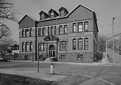 Municipal building | |
 Location of Windber in Somerset County, Pennsylvania. | |
| Coordinates: 40°14′07″N 78°49′51″W | |
| Country | United States |
| State | Pennsylvania |
| County | Somerset |
| Settled | 1897 |
| Incorporated | July 3, 1900 |
| Government | |
| • Type | Borough Council |
| • Mayor | Mike Thomas |
| Area | |
| • Total | 1.98 sq mi (5.12 km2) |
| • Land | 1.98 sq mi (5.12 km2) |
| • Water | 0.00 sq mi (0.00 km2) |
| Population | |
| • Total | 3,930 |
| • Estimate (2021)[2] | 3,893 |
| • Density | 1,929.22/sq mi (745.01/km2) |
| Time zone | UTC-5 (Eastern (EST)) |
| • Summer (DST) | UTC-4 (EDT) |
| Zip code | 15963 |
| Area code | 814 |
| FIPS code | 42-85632 |
| Website | Windber Borough |
The community was founded in 1897 by coal barons Charles and Edward Julius Berwind, owners of the Berwind Corporation; the name "Windber" simply switches the order of the two syllables in the family name "Berwind".[3]
A total of 8,013 people lived in Windber in 1910 and the figure rose to 9,057 as of 1940; the population was 3,930 at the time of the 2020 census.[2]
It is part of the Johnstown, Pennsylvania Metropolitan Statistical Area.
History
Windber was established in 1897 as a company town for nearby coal mines in the vicinity of Johnstown. The Berwind-White Coal Mining Company imported workers from eastern and southern Europe and exploited ethnic divisions in the area (which had been settled by Germans and Irish in the 19th century).
On Good Friday 1922 during the UMW General coal strike, coal miners walked out of the mines in Windber and several nearby locations in Somerset County, attempting to force the mine owners to recognize their United Mine Workers union, as well as accurately weigh the coal they mined.[4][5]

The company employed legal tactics (the United States Supreme Court decided two lawsuits) as well as strike-breakers, but the miners received considerable favorable national publicity and local support and held out until the end of the following summer.[5][4] However, the UMW successfully organized the mines during 1933, after the Great Depression led to the election of President Franklin Delano Roosevelt.
The Vintage Electric Streetcar Company, popularly called the "trolley graveyard", is located in Windber. The private scrapyard houses a number of PCC streetcars and other transit equipment from systems like the MBTA Green Line, which are sold for reuse or scrapped for parts.[6]
The Windber Historic District was listed on the National Register of Historic Places in 1991.[7]
Geography
Windber is located at 40°14′7″N 78°49′51″W (40.235161, -78.830864).[8]
According to the United States Census Bureau, the borough has a total area of 2.1 square miles (5.4 km2), all land.
Demographics
| Census | Pop. | Note | %± |
|---|---|---|---|
| 1910 | 8,013 | — | |
| 1920 | 9,462 | 18.1% | |
| 1930 | 9,205 | −2.7% | |
| 1940 | 9,057 | −1.6% | |
| 1950 | 8,010 | −11.6% | |
| 1960 | 6,994 | −12.7% | |
| 1970 | 6,332 | −9.5% | |
| 1980 | 5,585 | −11.8% | |
| 1990 | 4,756 | −14.8% | |
| 2000 | 4,395 | −7.6% | |
| 2010 | 4,138 | −5.8% | |
| 2020 | 3,930 | −5.0% | |
| 2021 (est.) | 3,893 | [2] | −0.9% |
| Sources:[9][10][11] | |||
As of the census[10] of 2000, there were 4,395 people, 2,019 households, and 1,185 families residing in the borough.
The population density was 2,118.8 people per square mile (818.1 people/km2). There were 2,177 housing units at an average density of 1,049.5 per square mile (405.2/km2).
The racial makeup of the borough was 99.29% White, 0.07% Native American, 0.09% Asian, 0.02% Pacific Islander, 0.16% from other races, and 0.36% from two or more races. Hispanic or Latino of any race were 0.57% of the population.
There were 2,019 households, out of which 25.1% had children under the age of eighteen living with them; 43.3% were married couples living together, 10.8% had a female householder with no husband present, and 41.3% were non-families. 38.7% of all households were made up of individuals, and 22.6% had someone living alone who was sixty-five years of age or older.
The average household size was 2.16 and the average family size was 2.89.
In the borough the population was spread out, with 21.3% under the age of eighteen, 6.7% from eighteen to twenty-four, 25.3% from twenty-five to forty-four, 22.1% from forty-five to sixty-four, and 24.6% who were sixty-five years of age or older. The median age was forty-three years.
For every one hundred females, there were 85.4 males. For every one hundred females who were aged eighteen or older, there were 81.9 males.
The median income for a household in the borough was $23,261, and the median income for a family was $31,860. Males had a median income of $24,861 compared with that of $18,886 for females.
The per capita income for the borough was $15,078.
Roughly 11.9% of families and 11.1% of the population were living below the poverty line, including 13.5% of those who were under the age of eighteen and 8.8% of those who were aged sixty-five or older.
Crime
Windber has ranked safer than thirteen percent of small cities and towns in Pennsylvania.
Government
Windber Borough Council:
- Mike Bryan, President of Council
- James Spinos, Vice President of Council
- John Holden
- Joe Pallo
- Doug Ledney
- Ron Mash
- Pete Lamonaca
Windber Borough Government Officials:
- Mike Thomas, Mayor
- Robin S. Gates, Borough Secretary/Administrative Assistant
- James Furmanchick, Borough Manager
Education
- Windber Area School District
- Windber Area High School
- Windber Area Middle School
- Windber Area Elementary School
Entertainment
The nearby Silver Drive-In first opened in 1962.[12] While other such facilities in the area have closed over the course of years, the Silver survived through public outcry over proposals to close and demolish it, making a comeback in 2005.[13][14][15] It is now the only drive-in theater in the Johnstown, Pennsylvania region.
Notable people
- Jim Bonfanti, drummer for the power-pop band the Raspberries, was born in Windber.
- Bill Elko, professional football player, grew up in Windber.[16]
- Alan Freed, radio disc jockey who coined the term "Rock and Roll," was born in Windber.
- Dave Geisel, retired MLB player
- Mark A. Heckler, President of Valaparaiso University
- Gene Heeter, professional football player, was born in Windber.
- Frank Kostro, retired MLB player
- Frank Kush, football coach, was born in Windber.
- Johnny Weissmuller, Olympic swimmer and later Hollywood star, lived in Windber as a child.
- J. Irving Whalley, United States congressman, lived for years in Windber.
See also
References
- "2019 U.S. Gazetteer Files". United States Census Bureau. Retrieved July 28, 2020.
- Bureau, US Census. "City and Town Population Totals: 2020—2021". Census.gov. US Census Bureau. Retrieved July 25, 2022.
- Espenshade, A. Howry (1925). Pennsylvania Place Names. State College, PA: Pennsylvania State College. p. 237.
- Kanarek, Harold K. (1975). "The Pennsylvania Anthracite Strike of 1922". The Pennsylvania Magazine of History and Biography. 99 (2): 207–225 – via JSTOR.
- historic marker at http://explorepahistory.com/hmarker.php?markerId=1-A-2CF
- Hoover, Amanda (September 6, 2015). "Why are old Green Line trolleys wasting away in rural Pennsylvania?". Boston Globe. Retrieved September 7, 2017.
- "National Register Information System". National Register of Historic Places. National Park Service. July 9, 2010.
- "US Gazetteer files: 2010, 2000, and 1990". United States Census Bureau. 2011-02-12. Retrieved April 23, 2011.
- "Census of Population and Housing". U.S. Census Bureau. Retrieved December 11, 2013.
- "U.S. Census website". United States Census Bureau. Retrieved January 31, 2008.
- "Incorporated Places and Minor Civil Divisions Datasets: Subcounty Resident Population Estimates: April 1, 2010 to July 1, 2012". Population Estimates. U.S. Census Bureau. Retrieved December 11, 2013.
- (12 June 2009). Reel success - County Amusement noting 60 years in movie business, The Tribune-Democrat
- (12 December 2008). Silver screen saved, The Tribune-Democrat
- (11 August 2006). Artist's touch adds character (s) to drive-in, The Tribune-Democrat
- (7 September 2008). Silver Drive-In owner mulls rezoning, sale, The Tribune-Democrat
- "At Last, Some D For San Diego - Sports Illustrated Vault". SI.com. Retrieved December 10, 2020.
External links
- Borough website
- Windber Area School District
- Historic American Engineering Record (HAER) No. PA-322, "Town of Windber"
Municipalities and communities of Somerset County, Pennsylvania, United States | ||
|---|---|---|
| Boroughs | 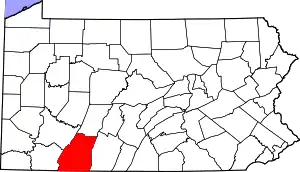 | |
| Townships | ||
| CDPs | ||
| Unincorporated communities | ||
| Footnotes | ‡This populated place also has portions in an adjacent county or counties | |