Wincrange
Wincrange (Luxembourgish: Wëntger, German: Wintger) is a commune and village in northern Luxembourg, in the canton of Clervaux. The commune is the largest in Luxembourg by geographic area.
Wincrange
| |
|---|---|
 | |
 Coat of arms | |
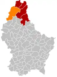 Map of Luxembourg with Wincrange highlighted in orange, and the canton in dark red | |
| Coordinates: 50.0533°N 5.9144°E | |
| Country | |
| Canton | Clervaux |
| Government | |
| • Mayor | Marcel Thommes (CSV) |
| Area | |
| • Total | 113.36 km2 (43.77 sq mi) |
| • Rank | 1st of 102 |
| Highest elevation | 528 m (1,732 ft) |
| • Rank | 11th of 102 |
| Lowest elevation | 350 m (1,150 ft) |
| • Rank | 100th of 102 |
| Population (2023) | |
| • Total | 4,804 |
| • Rank | 36th of 102 |
| • Density | 42/km2 (110/sq mi) |
| • Rank | 101st of 102 |
| Time zone | UTC+1 (CET) |
| • Summer (DST) | UTC+2 (CEST) |
| LAU 2 | LU0000502 |
| Website | wincrange.lu |
Wincrange was formed on 1 January 1978 from the former communes of Asselborn, Boevange, Hachiville, and Oberwampach, all in Clervaux canton. The law creating Wincrange was passed on 31 October 1977.[2]
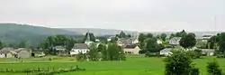
As of 2018, the village of Wincrange, which lies in the centre of the commune, has a population of 232.
Geography
Climate
Wincrange has a oceanic climate (Köppen Cfb). The annual average temperature is 8.8 °C (47.8 °F), the hottest month is July, 17.0 °C (62.6 °F), and the coldest month is January, 1.2 °C (34.2 °F). The annual precipitation is 819.2 millimetres (32.25 in), of which December is the wettest with 90.2 millimetres (3.55 in), while April is the driest with only 48.3 millimetres (1.90 in). The extreme temperature throughout the year ranged from −21.7 °C (−7.1 °F) on December 24, 2001 to 37.9 °C (100.2 °F) on July 25, 2019.
| Climate data for Wincrange (Asselborn), 1991-2020 normals | |||||||||||||
|---|---|---|---|---|---|---|---|---|---|---|---|---|---|
| Month | Jan | Feb | Mar | Apr | May | Jun | Jul | Aug | Sep | Oct | Nov | Dec | Year |
| Record high °C (°F) | 12.5 (54.5) |
20.3 (68.5) |
21.9 (71.4) |
23.3 (73.9) |
29.6 (85.3) |
33.4 (92.1) |
37.9 (100.2) |
36.5 (97.7) |
32.4 (90.3) |
26.9 (80.4) |
20.4 (68.7) |
13.7 (56.7) |
37.9 (100.2) |
| Average high °C (°F) | 3.2 (37.8) |
4.4 (39.9) |
8.7 (47.7) |
13.2 (55.8) |
17.3 (63.1) |
20.4 (68.7) |
22.5 (72.5) |
22.2 (72.0) |
18.0 (64.4) |
12.8 (55.0) |
7.1 (44.8) |
3.9 (39.0) |
12.8 (55.0) |
| Daily mean °C (°F) | 1.2 (34.2) |
1.7 (35.1) |
4.7 (40.5) |
8.4 (47.1) |
12.1 (53.8) |
15.2 (59.4) |
17.0 (62.6) |
16.5 (61.7) |
12.8 (55.0) |
9.0 (48.2) |
4.7 (40.5) |
2.0 (35.6) |
8.8 (47.8) |
| Average low °C (°F) | −1.5 (29.3) |
−1.5 (29.3) |
0.7 (33.3) |
3.2 (37.8) |
7.0 (44.6) |
9.9 (49.8) |
11.8 (53.2) |
11.4 (52.5) |
8.4 (47.1) |
5.7 (42.3) |
2.2 (36.0) |
−0.5 (31.1) |
4.7 (40.5) |
| Record low °C (°F) | −19.7 (−3.5) |
−18.4 (−1.1) |
−17.6 (0.3) |
−7.2 (19.0) |
−2.7 (27.1) |
−2.5 (27.5) |
3.2 (37.8) |
0.8 (33.4) |
−0.4 (31.3) |
−7.4 (18.7) |
−14.1 (6.6) |
−21.7 (−7.1) |
−21.7 (−7.1) |
| Average precipitation mm (inches) | 74.9 (2.95) |
61.0 (2.40) |
59.7 (2.35) |
48.3 (1.90) |
68.2 (2.69) |
70.5 (2.78) |
64.9 (2.56) |
80.6 (3.17) |
63.7 (2.51) |
67.5 (2.66) |
69.7 (2.74) |
90.2 (3.55) |
819.2 (32.25) |
| Average precipitation days (≥ 1.0 mm) | 12.8 | 11.2 | 11.0 | 9.1 | 10.3 | 10.4 | 10.2 | 10.3 | 9.4 | 11.5 | 12.9 | 13.8 | 132.7 |
| Source: NOAA[3] | |||||||||||||
Populated places
The commune consists of the following villages:
|
|
Notes:
a - partly shared with the former commune of Boevange
b - partly shared with the former commune of Asselborn
Population
References
- "WINCRANGE - Syvicol". www.syvicol.lu. Retrieved 3 April 2019.
- "Mémorial A, 1977, No. 70" (PDF) (in French). Service central de législation. Retrieved 2006-08-11.
- "Asselborn Climate Normals 1991-2020". National Oceanic and Atmospheric Administration. Archived from the original on 2023-09-11. Retrieved September 11, 2023.
- "Population par canton et commune". statistiques.public.lu. Retrieved 11 January 2022.
External links
 Media related to Wincrange at Wikimedia Commons
Places adjacent to Wincrange | ||||||||||||||||
|---|---|---|---|---|---|---|---|---|---|---|---|---|---|---|---|---|
| ||||||||||||||||
